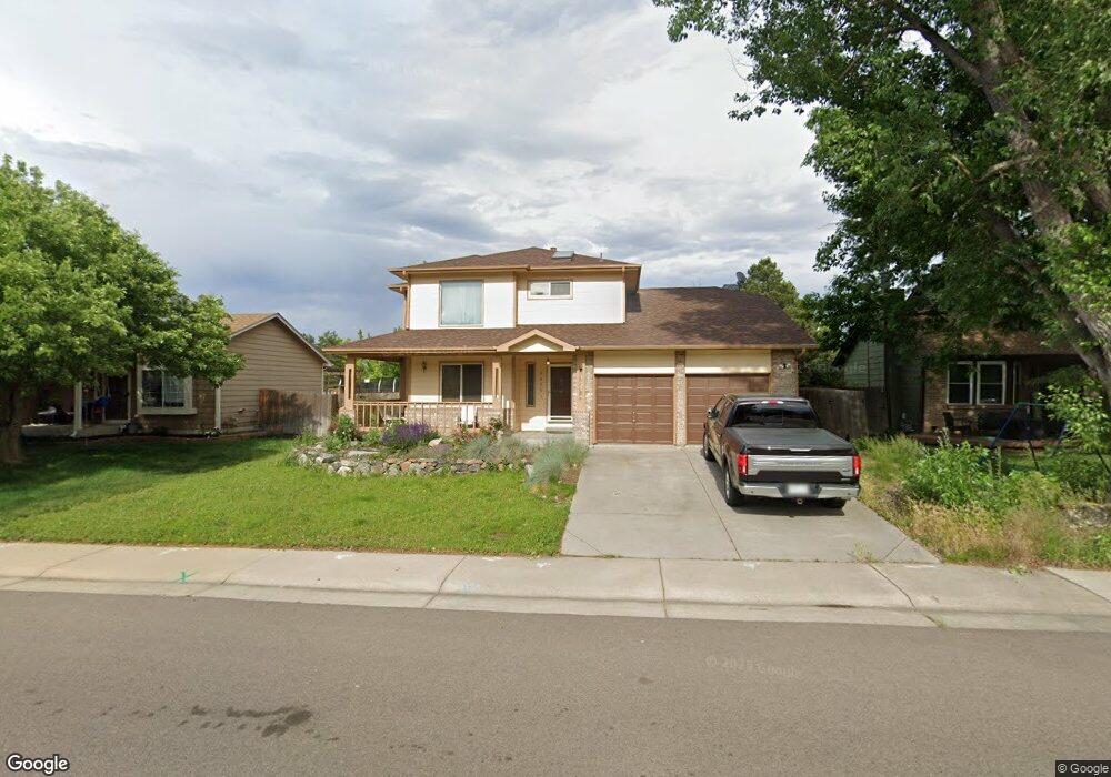
5426 S Simms Way Littleton, CO 80127
Westgold Meadows NeighborhoodEstimated Value: $628,000 - $699,000
3
Beds
5
Baths
2,220
Sq Ft
$294/Sq Ft
Est. Value
About This Home
This home is located at 5426 S Simms Way, Littleton, CO 80127 and is currently estimated at $653,168, approximately $294 per square foot. 5426 S Simms Way is a home located in Jefferson County with nearby schools including Mount Carbon Elementary School, Summit Ridge Middle School, and Dakota Ridge Senior High School.
Ownership History
Date
Name
Owned For
Owner Type
Purchase Details
Closed on
Feb 16, 2021
Sold by
Riead Julie M and Riead Stephen A
Bought by
Riead Stephen A
Current Estimated Value
Home Financials for this Owner
Home Financials are based on the most recent Mortgage that was taken out on this home.
Original Mortgage
$295,000
Outstanding Balance
$263,845
Interest Rate
2.7%
Mortgage Type
New Conventional
Estimated Equity
$389,323
Purchase Details
Closed on
Aug 24, 2012
Sold by
Cooper Julie M
Bought by
Riead Julie M and Riead Stephen A
Home Financials for this Owner
Home Financials are based on the most recent Mortgage that was taken out on this home.
Original Mortgage
$254,449
Interest Rate
3.75%
Mortgage Type
FHA
Purchase Details
Closed on
Jun 20, 2008
Sold by
Mckeown John A
Bought by
Cooper Julie M and Riead Stephen A
Home Financials for this Owner
Home Financials are based on the most recent Mortgage that was taken out on this home.
Original Mortgage
$261,890
Interest Rate
6.08%
Mortgage Type
FHA
Purchase Details
Closed on
Jan 9, 2004
Sold by
Collins Kenneth G and Collins Alvina M
Bought by
Mckeown John A
Home Financials for this Owner
Home Financials are based on the most recent Mortgage that was taken out on this home.
Original Mortgage
$220,000
Interest Rate
5.86%
Mortgage Type
Unknown
Purchase Details
Closed on
Jan 19, 1999
Sold by
Wolbach Mark F and Wolbach Mary C
Bought by
Collins Kenneth G and Collins Alvina M
Home Financials for this Owner
Home Financials are based on the most recent Mortgage that was taken out on this home.
Original Mortgage
$170,859
Interest Rate
6.75%
Mortgage Type
VA
Purchase Details
Closed on
Feb 24, 1994
Sold by
Zhiou James and Chiu Tammy
Bought by
Wolbach Mark F and Wolbach Mary C
Home Financials for this Owner
Home Financials are based on the most recent Mortgage that was taken out on this home.
Original Mortgage
$134,900
Interest Rate
6.94%
Create a Home Valuation Report for This Property
The Home Valuation Report is an in-depth analysis detailing your home's value as well as a comparison with similar homes in the area
Home Values in the Area
Average Home Value in this Area
Purchase History
| Date | Buyer | Sale Price | Title Company |
|---|---|---|---|
| Riead Stephen A | -- | Fidelity National Title | |
| Riead Julie M | -- | Fntc | |
| Cooper Julie M | $266,000 | Fahtco | |
| Mckeown John A | $275,000 | -- | |
| Collins Kenneth G | $189,950 | Land Title | |
| Wolbach Mark F | $149,900 | Land Title |
Source: Public Records
Mortgage History
| Date | Status | Borrower | Loan Amount |
|---|---|---|---|
| Open | Riead Stephen A | $295,000 | |
| Closed | Riead Julie M | $254,449 | |
| Previous Owner | Cooper Julie M | $261,890 | |
| Previous Owner | Mckeown John A | $220,000 | |
| Previous Owner | Collins Kenneth G | $170,859 | |
| Previous Owner | Wolbach Mark F | $134,900 |
Source: Public Records
Tax History Compared to Growth
Tax History
| Year | Tax Paid | Tax Assessment Tax Assessment Total Assessment is a certain percentage of the fair market value that is determined by local assessors to be the total taxable value of land and additions on the property. | Land | Improvement |
|---|---|---|---|---|
| 2024 | $3,534 | $36,084 | $8,476 | $27,608 |
| 2023 | $3,534 | $36,084 | $8,476 | $27,608 |
| 2022 | $3,163 | $31,088 | $6,783 | $24,305 |
| 2021 | $3,201 | $31,983 | $6,978 | $25,005 |
| 2020 | $3,209 | $32,154 | $5,719 | $26,435 |
| 2019 | $3,176 | $32,154 | $5,719 | $26,435 |
| 2018 | $2,818 | $27,583 | $5,222 | $22,361 |
| 2017 | $2,574 | $27,583 | $5,222 | $22,361 |
| 2016 | $2,479 | $25,613 | $7,074 | $18,539 |
| 2015 | $2,224 | $25,613 | $7,074 | $18,539 |
| 2014 | $2,224 | $21,538 | $5,570 | $15,968 |
Source: Public Records
Map
Nearby Homes
- 11278 W Progress Ave
- 11152 W Crestline Dr
- 12254 W Arlington Ave
- 11962 W Long Cir Unit 103
- 11972 W Long Cir Unit 104
- 5667 S Urban St Unit 304
- 12233 W Cross Dr Unit 307
- 11963 W Long Cir Unit 101
- 12158 W Dorado Place Unit 205
- 11424 W Belleview Dr
- 12208 W Dorado Place Unit 306
- 12304 W Cross Dr Unit 304
- 12288 W Dorado Place Unit 301
- 5813 S Taft Way
- 5013 S Queen Ct
- 5657 S Oak St
- 5321 S Nelson St
- 5790 S Parfet St
- 10815 W Alamo Place
- 12650 W Belmont Ave
- 5436 S Simms Way
- 5416 S Simms Way
- 5446 S Simms Way
- 5406 S Simms Way
- 5425 S Simms Way
- 5415 S Simms Way
- 5445 S Simms Way
- 5456 S Simms Way
- 5405 S Simms Way
- 5455 S Simms Way
- 5381 S Routt Way
- 5387 S Routt Way
- 5428 S Swadley Ct
- 5466 S Simms Way
- 5391 S Routt Way
- 5438 S Swadley Ct
- 5377 S Routt Way
- 5418 S Swadley Ct
- 5465 S Simms Way
- 5397 S Routt Way