
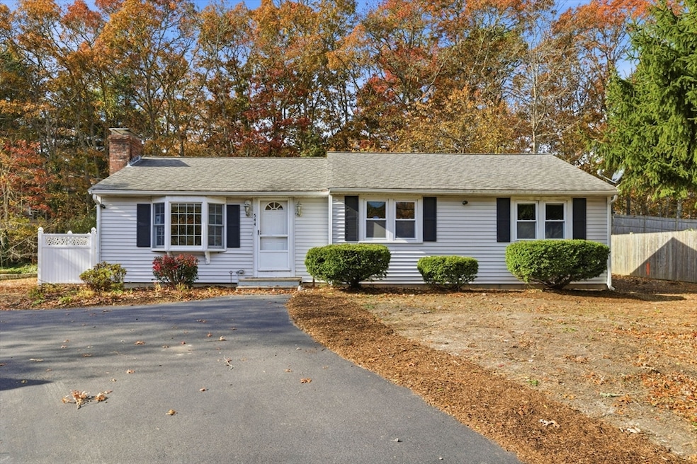
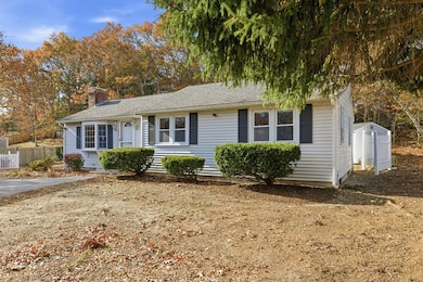
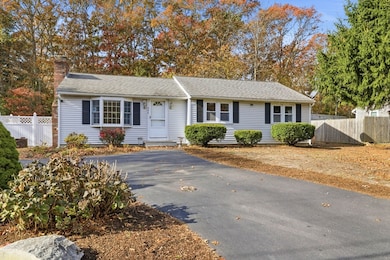
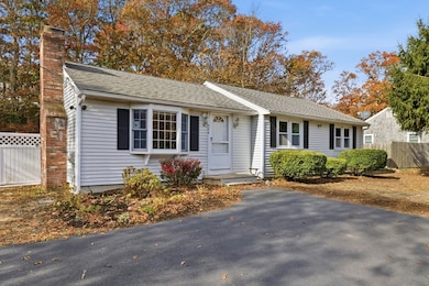
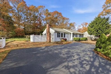

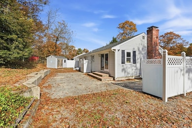
544 Cotuit Rd Mashpee, MA 02649
Estimated payment $2,849/month
Total Views
119,874
3
Beds
1.5
Baths
1,062
Sq Ft
$480
Price per Sq Ft
Highlights
- Hot Property
- Ranch Style House
- Attic
- Mashpee High School Rated A-
- Wood Flooring
- 1 Fireplace
About This Home
Welcome to this charming 3-bedroom, 1.5-bath ranch-style home that offers a perfect blend of comfort and potential. Featuring a spacious single-level layout, this home boasts bright and airy living spaces with hardwood floors throughout. The functional kitchen and dining area provide a cozy setting for everyday meals or entertaining guests. A full unfinished basement offers ample storage space and the opportunity to create a custom workshop or recreation room. With natural gas heat for easy maintenance and consistent warmth, this home is ideal for first-time buyers, those looking to downsize, or anyone seeking a smart investment. Close to highways, shopping, restaurants and more, this property is ready for your personal touch and future memories. Passing Title V!!
Home Details
Home Type
- Single Family
Est. Annual Taxes
- $2,689
Year Built
- Built in 1973
Lot Details
- 0.3 Acre Lot
- Level Lot
- Property is zoned R5
Home Design
- Ranch Style House
- Frame Construction
- Shingle Roof
- Concrete Perimeter Foundation
Interior Spaces
- 1,062 Sq Ft Home
- 1 Fireplace
- Attic
Kitchen
- Range
- Dishwasher
Flooring
- Wood
- Tile
Bedrooms and Bathrooms
- 3 Bedrooms
Laundry
- Dryer
- Washer
Unfinished Basement
- Basement Fills Entire Space Under The House
- Interior Basement Entry
Parking
- 4 Car Parking Spaces
- Paved Parking
- 4 Open Parking Spaces
Outdoor Features
- Bulkhead
- Patio
- Outdoor Gas Grill
Utilities
- No Cooling
- Forced Air Heating System
- Heating System Uses Natural Gas
- 110 Volts
- Electric Water Heater
- Sewer Inspection Required for Sale
Listing and Financial Details
- Assessor Parcel Number M:16 B:32 L:0,2348019
Community Details
Recreation
- Park
- Jogging Path
Additional Features
- No Home Owners Association
- Shops
Map
Create a Home Valuation Report for This Property
The Home Valuation Report is an in-depth analysis detailing your home's value as well as a comparison with similar homes in the area
Tax History
| Year | Tax Paid | Tax Assessment Tax Assessment Total Assessment is a certain percentage of the fair market value that is determined by local assessors to be the total taxable value of land and additions on the property. | Land | Improvement |
|---|---|---|---|---|
| 2025 | $2,689 | $406,200 | $167,400 | $238,800 |
| 2024 | $2,442 | $379,800 | $152,200 | $227,600 |
| 2023 | $2,327 | $332,000 | $144,900 | $187,100 |
| 2022 | $2,337 | $286,000 | $130,900 | $155,100 |
| 2021 | $2,229 | $245,800 | $117,900 | $127,900 |
| 2020 | $2,150 | $236,500 | $113,400 | $123,100 |
| 2019 | $2,074 | $229,200 | $113,400 | $115,800 |
| 2018 | $0 | $210,800 | $113,400 | $97,400 |
| 2017 | $0 | $200,600 | $113,400 | $87,200 |
| 2016 | $1,808 | $195,700 | $113,400 | $82,300 |
| 2015 | $1,762 | $193,400 | $113,400 | $80,000 |
| 2014 | $1,793 | $190,900 | $112,000 | $78,900 |
Source: Public Records
Property History
| Date | Event | Price | List to Sale | Price per Sq Ft |
|---|---|---|---|---|
| 11/20/2025 11/20/25 | For Sale | $510,000 | -- | $480 / Sq Ft |
Source: MLS Property Information Network (MLS PIN)
Purchase History
| Date | Type | Sale Price | Title Company |
|---|---|---|---|
| Quit Claim Deed | $748,875 | -- | |
| Deed | -- | -- |
Source: Public Records
Mortgage History
| Date | Status | Loan Amount | Loan Type |
|---|---|---|---|
| Previous Owner | $143,500 | Purchase Money Mortgage |
Source: Public Records
About the Listing Agent
Since 2019, Kerry has been fully dedicated to real estate. She takes pride in her achievements, having assisted hundreds of families in buying, selling, or renting homes. Her commitment to exceptional customer service and clear communication ensures that each transaction is as stress-free as possible. Before transitioning to real estate, she devoted almost two decades to the healthcare field. Specifically, she served as an occupational therapist and rehabilitation manager in geriatric
Kerry's Other Listings
Source: MLS Property Information Network (MLS PIN)
MLS Number: 73456029
APN: MASH-000016-000032
Disclaimer: Certain information contained herein is derived from information provided by parties other than Homes.com. All information provided is deemed reliable, but is not guaranteed to be accurate and should be independently verified.
![]() The property listing data and information, or the Images, set forth herein were provided to MLS Property Information Network, Inc. from third party sources, including sellers, lessors and public records, and were compiled by MLS Property Information Network, Inc. The property listing data and information, and the Images, are for the personal, non-commercial use of consumers having a good faith interest in purchasing or leasing listed properties of the type displayed to them and may not be used for any purpose other than to identify prospective properties which such consumers may have a good faith interest in purchasing or leasing. MLS Property Information Network, Inc. and its subscribers disclaim any and all representations and warranties as to the accuracy of the property listing data and information, or as to the accuracy of any of the Images, set forth herein.
The property listing data and information, or the Images, set forth herein were provided to MLS Property Information Network, Inc. from third party sources, including sellers, lessors and public records, and were compiled by MLS Property Information Network, Inc. The property listing data and information, and the Images, are for the personal, non-commercial use of consumers having a good faith interest in purchasing or leasing listed properties of the type displayed to them and may not be used for any purpose other than to identify prospective properties which such consumers may have a good faith interest in purchasing or leasing. MLS Property Information Network, Inc. and its subscribers disclaim any and all representations and warranties as to the accuracy of the property listing data and information, or as to the accuracy of any of the Images, set forth herein.
Nearby Homes
- 68 Fox Hill Rd
- 22 Candlewood Ln
- 10 Candlewood Ln
- 45 Fox Hill Rd
- 35 Santuit Pond Way Unit 7B
- 16 Balfour Ln
- 24 Widow Coombs Walk
- 63 Deer Ridge Rd
- 20 Lakewood Dr
- 36 Moon Compass Ln
- 45 Pequot Rd
- 19 Oriole Ln
- 235 Main St
- 48 Holly Ridge Dr
- 173 Main St
- 9 Viking Ln
- 52 Old Colony Dr
- 170 Forest Hills Rd
- 78 Brittany Dr
- 93 Deerfield Rd
- 185 Cotuit Rd Unit 1 Juniper
- 8 Artisan Way
- 79 Ma-130
- 5 Anthonys Way
- 33 Green House Rd
- 20 Brigantine Ave
- 89 Sunset Cir Unit SI ID1386128P
- 50 Hane Rd
- 308 Patriot Way Unit 308
- 65 Starboard Ln
- 282 Parker Rd
- 101 Longfellow Dr
- 33 Water St
- 6 Spinnaker Ln Unit A
- 205 Nyes Neck Rd
- 38A Russell Rd
- 1336 County Rd
- 495 Sandwich Rd
- 15 Tupper Rd Unit 1
- 94 Cottonwood Ln
Your Personal Tour Guide
Ask me questions while you tour the home.