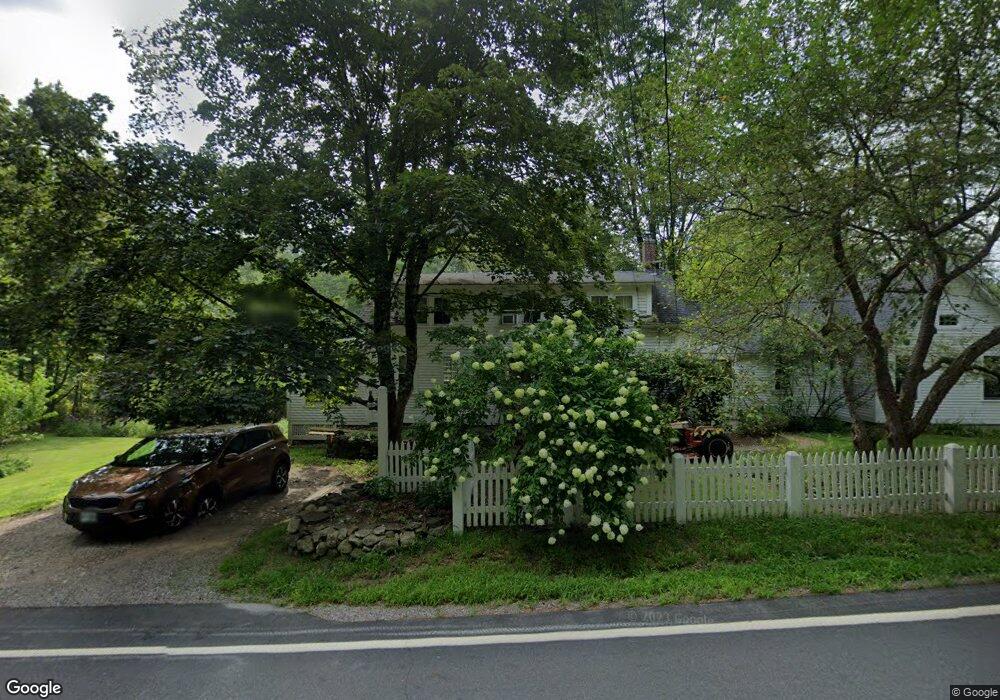
544 Northwest Rd Canterbury, NH 03224
Estimated Value: $400,000 - $573,000
3
Beds
2
Baths
2,194
Sq Ft
$227/Sq Ft
Est. Value
About This Home
This home is located at 544 Northwest Rd, Canterbury, NH 03224 and is currently estimated at $497,452, approximately $226 per square foot. 544 Northwest Rd is a home located in Merrimack County with nearby schools including Canterbury Elementary School, Belmont Middle School, and Belmont High School.
Ownership History
Date
Name
Owned For
Owner Type
Purchase Details
Closed on
Jul 20, 1998
Sold by
Revoc Lucia Kittredge
Bought by
Bowser Matthew P and Bowser Stephanie A
Current Estimated Value
Home Financials for this Owner
Home Financials are based on the most recent Mortgage that was taken out on this home.
Original Mortgage
$133,000
Interest Rate
6.98%
Create a Home Valuation Report for This Property
The Home Valuation Report is an in-depth analysis detailing your home's value as well as a comparison with similar homes in the area
Home Values in the Area
Average Home Value in this Area
Purchase History
| Date | Buyer | Sale Price | Title Company |
|---|---|---|---|
| Bowser Matthew P | $140,000 | -- |
Source: Public Records
Mortgage History
| Date | Status | Borrower | Loan Amount |
|---|---|---|---|
| Open | Bowser Matthew P | $180,000 | |
| Closed | Bowser Matthew P | $133,000 |
Source: Public Records
Tax History Compared to Growth
Tax History
| Year | Tax Paid | Tax Assessment Tax Assessment Total Assessment is a certain percentage of the fair market value that is determined by local assessors to be the total taxable value of land and additions on the property. | Land | Improvement |
|---|---|---|---|---|
| 2024 | $5,906 | $260,411 | $96,711 | $163,700 |
| 2023 | $5,472 | $260,562 | $96,862 | $163,700 |
| 2022 | $5,433 | $261,178 | $97,478 | $163,700 |
| 2021 | $5,373 | $261,974 | $97,574 | $164,400 |
| 2020 | $5,649 | $204,762 | $77,462 | $127,300 |
| 2019 | $5,711 | $204,922 | $77,622 | $127,300 |
| 2018 | $5,448 | $205,033 | $77,733 | $127,300 |
| 2017 | $5,332 | $205,234 | $77,934 | $127,300 |
| 2016 | $4,965 | $198,999 | $77,899 | $121,100 |
| 2015 | $5,091 | $191,669 | $77,969 | $113,700 |
| 2014 | $5,187 | $191,742 | $78,042 | $113,700 |
| 2013 | $5,008 | $191,579 | $78,579 | $113,000 |
Source: Public Records
Map
Nearby Homes
- 294 Old Tilton Rd
- 533 Northwest Rd
- 562 Northwest Rd
- 550 Northwest Rd Unit 15
- 532 Northwest Rd
- 0 Rum Brook Rd
- 14 Rum Brook Rd
- 568 Northwest Rd
- 20 Rum Brook Rd
- 516 Northwest Rd
- 260 Old Tilton Rd
- 515 Northwest Rd
- Lot 15 Northwest Rd
- 576 Northwest Rd
- 26 Rum Brook Rd
- 256 Old Tilton Rd
- 259 Old Tilton Rd
- 581 Northwest Rd
- 581 Northwest Rd
- 500 Northwest Rd