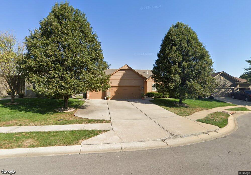
545 Avondale Ln Raymore, MO 64083
Estimated Value: $422,000 - $476,000
3
Beds
3
Baths
1,310
Sq Ft
$335/Sq Ft
Est. Value
About This Home
This home is located at 545 Avondale Ln, Raymore, MO 64083 and is currently estimated at $438,710, approximately $334 per square foot. 545 Avondale Ln is a home located in Cass County with nearby schools including Creekmoor Elementary School, Raymore-Peculiar East Middle School, and Raymore-Peculiar Senior High School.
Ownership History
Date
Name
Owned For
Owner Type
Purchase Details
Closed on
Feb 15, 2026
Sold by
Anderson Larry and Anderson Faye L
Bought by
Larry Anderson And Faye L Anderson Trust and Anderson
Current Estimated Value
Purchase Details
Closed on
Dec 16, 2008
Sold by
C & M Builders Inc
Bought by
Anderson Larry and Anderson Faye L
Home Financials for this Owner
Home Financials are based on the most recent Mortgage that was taken out on this home.
Original Mortgage
$233,985
Interest Rate
6.19%
Mortgage Type
New Conventional
Purchase Details
Closed on
Jul 14, 2008
Sold by
Cooper Land Development Inc
Bought by
C & M Builders Inc
Home Financials for this Owner
Home Financials are based on the most recent Mortgage that was taken out on this home.
Original Mortgage
$201,200
Interest Rate
6.4%
Mortgage Type
Construction
Create a Home Valuation Report for This Property
The Home Valuation Report is an in-depth analysis detailing your home's value as well as a comparison with similar homes in the area
Home Values in the Area
Average Home Value in this Area
Purchase History
| Date | Buyer | Sale Price | Title Company |
|---|---|---|---|
| Larry Anderson And Faye L Anderson Trust | -- | None Listed On Document | |
| Anderson Larry | -- | -- | |
| C & M Builders Inc | -- | -- |
Source: Public Records
Mortgage History
| Date | Status | Borrower | Loan Amount |
|---|---|---|---|
| Previous Owner | Anderson Larry | $233,985 | |
| Previous Owner | C & M Builders Inc | $201,200 |
Source: Public Records
Tax History
| Year | Tax Paid | Tax Assessment Tax Assessment Total Assessment is a certain percentage of the fair market value that is determined by local assessors to be the total taxable value of land and additions on the property. | Land | Improvement |
|---|---|---|---|---|
| 2025 | $4,311 | $59,790 | $9,350 | $50,440 |
| 2024 | $4,311 | $52,970 | $8,480 | $44,490 |
| 2023 | $4,305 | $52,970 | $8,480 | $44,490 |
| 2022 | $3,847 | $47,020 | $8,480 | $38,540 |
| 2021 | $3,847 | $47,020 | $8,480 | $38,540 |
| 2020 | $4,066 | $48,810 | $8,480 | $40,330 |
| 2019 | $3,925 | $48,810 | $8,480 | $40,330 |
| 2018 | $3,885 | $46,650 | $8,480 | $38,170 |
| 2017 | $3,598 | $46,650 | $8,480 | $38,170 |
| 2016 | $3,598 | $44,850 | $8,480 | $36,370 |
| 2015 | $3,601 | $44,850 | $8,480 | $36,370 |
| 2014 | $3,602 | $44,850 | $8,480 | $36,370 |
| 2013 | -- | $44,850 | $8,480 | $36,370 |
Source: Public Records
Map
Nearby Homes
- 518 Andypaul Ct
- 1323 W Johns Blvd
- 1217 Hampton Dr
- 1412 W Stone Blvd
- 701 Hampstead Dr
- 851 Creekmoor Pond Ln
- 215 Scott Dr
- 0 Scott Dr
- 610 Wild Lupine Ln
- 610 Foxglove Ln
- 604 Wild Lupine Ln
- 606 Foxglove Ln
- 602 Foxglove Ln
- 604 Foxglove Ln
- 502 Foxglove Ln
- 608 Foxglove Ln
- 614 Foxglove Ln
- 701 Wood Sage Ct
- 707 Red Clover Ct
- 705 Red Clover Ct
- 547 Avondale Ln
- 543 Avondale Ln
- 549 Avondale Ln
- 541 Avondale Ln
- 546 Avondale Ln
- 544 Avondale Ln
- 553 Avondale Ln
- 540 Avondale Ln
- 548 Avondale Ln
- 542 Avondale Ln
- 550 Avondale Ln
- 559 Avondale Ln
- 1300 Ashbury Ln
- 552 Avondale Ln
- 1302 Ashbury Ln
- 554 Avondale Ln
- 1252 Granada Dr
- 1244 Granada Dr Unit 1248
- 601 Avondale Ln
- 1256 Granada Dr
Your Personal Tour Guide
Ask me questions while you tour the home.