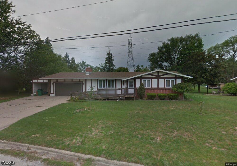
5466 Michael Rd Bay City, MI 48706
Estimated Value: $180,946 - $223,000
3
Beds
2
Baths
1,400
Sq Ft
$150/Sq Ft
Est. Value
About This Home
This home is located at 5466 Michael Rd, Bay City, MI 48706 and is currently estimated at $209,487, approximately $149 per square foot. 5466 Michael Rd is a home located in Bay County with nearby schools including Mackensen Elementary School, Western Middle School, and Bay City Western High School.
Ownership History
Date
Name
Owned For
Owner Type
Purchase Details
Closed on
Nov 7, 2018
Sold by
Wrzeskinksi Jerod T and Wrzeskinksi Jill R
Bought by
Wrz M Rental Llc
Current Estimated Value
Purchase Details
Closed on
Apr 30, 2018
Sold by
Jessica Dore
Bought by
Wrzesinski Jill R and Wrzesinski Jerod T
Purchase Details
Closed on
Jun 27, 2011
Sold by
Bowersock Marilyn K and Bowersock Lee Allen
Bought by
Bowersock Marilyn K and Dore Jessica
Purchase Details
Closed on
Jul 11, 1985
Sold by
Fritz Kenneth J and Fritz Cecilia S
Bought by
Bowersock Lee A and Bowersock Marilyn K
Create a Home Valuation Report for This Property
The Home Valuation Report is an in-depth analysis detailing your home's value as well as a comparison with similar homes in the area
Home Values in the Area
Average Home Value in this Area
Purchase History
| Date | Buyer | Sale Price | Title Company |
|---|---|---|---|
| Wrz M Rental Llc | -- | None Available | |
| Wrzesinski Jill R | -- | None Listed On Document | |
| Bowersock Marilyn K | -- | None Available | |
| Bowersock Lee A | $68,000 | -- |
Source: Public Records
Tax History
| Year | Tax Paid | Tax Assessment Tax Assessment Total Assessment is a certain percentage of the fair market value that is determined by local assessors to be the total taxable value of land and additions on the property. | Land | Improvement |
|---|---|---|---|---|
| 2025 | $2,342 | $106,000 | $0 | $0 |
| 2024 | $2,272 | $101,600 | $0 | $0 |
| 2023 | $2,164 | $99,400 | $0 | $0 |
| 2022 | $3,501 | $76,500 | $0 | $0 |
| 2021 | $3,307 | $82,900 | $82,900 | $0 |
| 2020 | $3,283 | $76,000 | $76,000 | $0 |
| 2019 | $3,149 | $65,000 | $0 | $0 |
| 2018 | $2,016 | $64,900 | $0 | $0 |
| 2017 | $1,920 | $66,200 | $0 | $0 |
| 2016 | $1,926 | $64,300 | $0 | $64,300 |
| 2015 | $812 | $62,700 | $0 | $62,700 |
| 2014 | $812 | $54,600 | $0 | $54,600 |
Source: Public Records
Map
Nearby Homes
- 158 Salzburg Rd
- 5620 W Spring Knoll Dr
- 2975 Continental Dr
- 2985 Continental Dr
- 5629 Firethorne Dr
- 5603 Firethorne Dr
- 5452 Goetz Ct
- 2984 Thunderbird Dr
- 2994 Thunderbird Dr
- 40 Westside Saginaw Rd
- 0 3 Mile Rd
- 5700 3 Mile Rd
- 3052 E Fisher Rd
- 3400 Fairway Dr
- 3118 E Fisher Rd
- 3176 E Fisher Rd
- 2469 2 Mile Rd
- 0 Fisher Rd
- 0 S Two Mile Rd Unit 50142051
- 1305 S Euclid Ave
- 5478 Michael Rd
- 5478 Michael Rd
- 5477 Michael Rd
- 2906 Easy St
- 5456 Michael Rd
- 5491 Michael Rd
- 5444 Michael Rd
- 5449 Michael Rd
- 5485 Michael Dr
- 5485 Michael Rd
- 5491 Michael Dr
- 2914 Easy St
- 5475 Harvest Ct
- 5459 Harvest Ct
- 2867 E Salzburg Rd
- 5450 Easy St
- 5439 Michael Rd
- 5455 Harvest Ct
- 2921 E Salzburg Rd
- 5436 Michael Rd
Your Personal Tour Guide
Ask me questions while you tour the home.