Estimated Value: $521,975 - $581,000
3
Beds
1
Bath
1,442
Sq Ft
$386/Sq Ft
Est. Value
About This Home
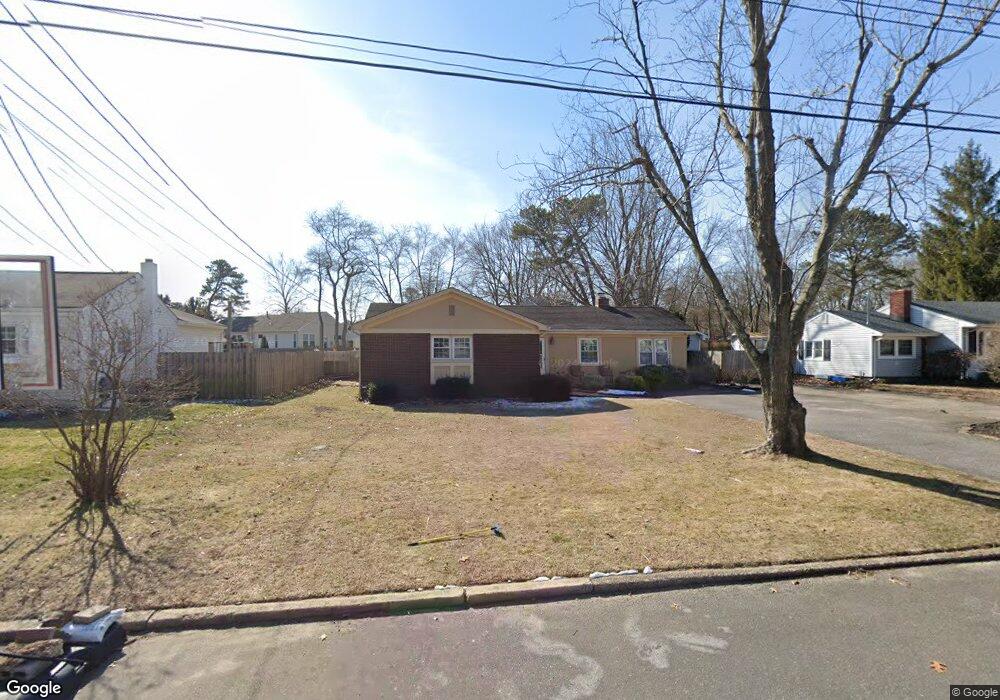
This home is located at 547 Azalea Dr, Brick, NJ 08724 and is currently estimated at $556,244, approximately $385 per square foot. 547 Azalea Dr is a home located in Ocean County with nearby schools including Midstreams Elementary School, Veterans Memorial Middle School, and Brick Township Memorial High School.
Ownership History
Date
Name
Owned For
Owner Type
Purchase Details
Closed on
Apr 26, 2001
Sold by
Zaremba Margaret
Bought by
Fanning Michael and Fanning Tara
Current Estimated Value
Home Financials for this Owner
Home Financials are based on the most recent Mortgage that was taken out on this home.
Original Mortgage
$162,700
Outstanding Balance
$59,942
Interest Rate
6.85%
Mortgage Type
FHA
Estimated Equity
$496,302
Purchase Details
Closed on
Apr 28, 1998
Sold by
Oflaherty Richard A and Oflaherty Kathleen M
Bought by
Zaremba Margaret
Home Financials for this Owner
Home Financials are based on the most recent Mortgage that was taken out on this home.
Original Mortgage
$125,256
Interest Rate
7.08%
Mortgage Type
FHA
Create a Home Valuation Report for This Property
The Home Valuation Report is an in-depth analysis detailing your home's value as well as a comparison with similar homes in the area
Home Values in the Area
Average Home Value in this Area
Purchase History
| Date | Buyer | Sale Price | Title Company |
|---|---|---|---|
| Fanning Michael | $164,000 | -- | |
| Fanning Michael | $164,000 | -- | |
| Zaremba Margaret | $125,000 | -- |
Source: Public Records
Mortgage History
| Date | Status | Borrower | Loan Amount |
|---|---|---|---|
| Open | Fanning Michael | $162,700 | |
| Closed | Fanning Michael | $162,700 | |
| Previous Owner | Zaremba Margaret | $125,256 |
Source: Public Records
Tax History
| Year | Tax Paid | Tax Assessment Tax Assessment Total Assessment is a certain percentage of the fair market value that is determined by local assessors to be the total taxable value of land and additions on the property. | Land | Improvement |
|---|---|---|---|---|
| 2025 | $6,517 | $249,700 | $132,600 | $117,100 |
| 2024 | $6,185 | $249,700 | $132,600 | $117,100 |
Source: Public Records
Map
Nearby Homes
- 531 Azalea Dr
- 506 Azalea Dr
- 516 Driscol Dr
- 1 Drury Ct
- 441 17th Ave
- 432 18th Ave
- 22 Cedar Village Blvd
- 124 Roosevelt Dr
- 2183 New Jersey 88
- 3403 Bridge Ave Unit 13
- 2193 Route 88
- 106 Coolidge Dr
- 550 Crestview Terrace
- 22 Coolidge Dr
- 14 Coolidge Dr
- 295 Madison Ct
- 101 Duchess Ln
- 512 Oak Terrace
- 339 Prospect Dr
- 106 Arrowhead Park Dr
Your Personal Tour Guide
Ask me questions while you tour the home.