
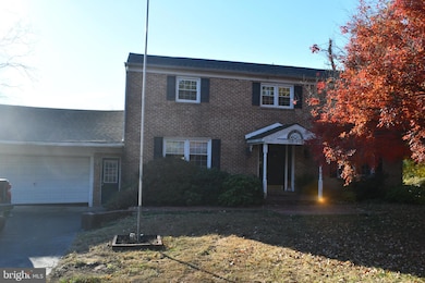
547 Mccarty Dr Furlong, PA 18925
Estimated payment $3,895/month
Highlights
- Colonial Architecture
- Traditional Floor Plan
- 2 Fireplaces
- Bridge Valley Elementary School Rated A
- Wood Flooring
- No HOA
About This Home
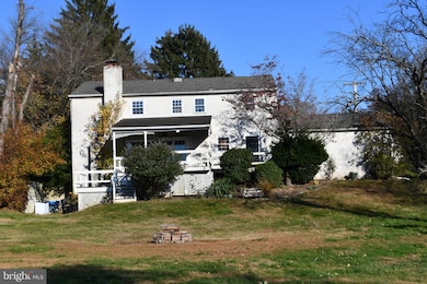
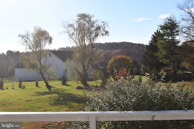
Handsome brick colonial home on an acre lot with picturesque mountainside view in Doylestown Twp. This 4 bdrm home with finished basement has been a rental property for over a decade and is in need of extensive cosmetic updating to the interior. The sellers are in the process of coordinating contractors to update but are open to offers prior to the work being completed. A perfect timing opportunity exists for contractors/investors heading into winter where work may be slowing down. If sellers complete work themselves, we will be increasing price accordingly. Contact listing agent for details. Sellers Disclosure to be uploaded in the coming days.
Listing Agent
jckcullen@msn.com Coldwell Banker Realty License #AB067169 Listed on: 11/24/2025
Home Details
Home Type
- Single Family
Est. Annual Taxes
- $7,129
Year Built
- Built in 1971
Lot Details
- 1 Acre Lot
- Property is in below average condition
- Property is zoned R1
Parking
- 2 Car Attached Garage
- 4 Driveway Spaces
Home Design
- Colonial Architecture
- Block Foundation
- Shingle Roof
Interior Spaces
- Property has 2 Levels
- Traditional Floor Plan
- Ceiling Fan
- 2 Fireplaces
- Family Room
- Living Room
- Dining Room
- Partially Finished Basement
- Exterior Basement Entry
Kitchen
- Built-In Range
- Dishwasher
Flooring
- Wood
- Carpet
- Tile or Brick
Bedrooms and Bathrooms
- 4 Bedrooms
Utilities
- Forced Air Heating and Cooling System
- Heating System Uses Oil
- Well
- Electric Water Heater
- On Site Septic
- Septic Tank
Community Details
- No Home Owners Association
- Amadon Subdivision
Listing and Financial Details
- Tax Lot 032
- Assessor Parcel Number 09-035-032
Map
Home Values in the Area
Average Home Value in this Area
Tax History
| Year | Tax Paid | Tax Assessment Tax Assessment Total Assessment is a certain percentage of the fair market value that is determined by local assessors to be the total taxable value of land and additions on the property. | Land | Improvement |
|---|---|---|---|---|
| 2025 | $6,512 | $36,800 | $7,680 | $29,120 |
| 2024 | $6,512 | $36,800 | $7,680 | $29,120 |
| 2023 | $6,210 | $36,800 | $7,680 | $29,120 |
| 2022 | $6,140 | $36,800 | $7,680 | $29,120 |
| 2021 | $6,014 | $36,800 | $7,680 | $29,120 |
| 2020 | $5,986 | $36,800 | $7,680 | $29,120 |
| 2019 | $5,922 | $36,800 | $7,680 | $29,120 |
| 2018 | $5,904 | $36,800 | $7,680 | $29,120 |
| 2017 | $5,858 | $36,800 | $7,680 | $29,120 |
| 2016 | $5,821 | $36,800 | $7,680 | $29,120 |
| 2015 | -- | $36,800 | $7,680 | $29,120 |
| 2014 | -- | $36,800 | $7,680 | $29,120 |
Property History
| Date | Event | Price | List to Sale | Price per Sq Ft |
|---|---|---|---|---|
| 11/24/2025 11/24/25 | For Sale | $625,000 | -- | $187 / Sq Ft |
Purchase History
| Date | Type | Sale Price | Title Company |
|---|---|---|---|
| Deed | $174,500 | Lawyers Title Insurance Corp | |
| Deed | $72,000 | -- |
Mortgage History
| Date | Status | Loan Amount | Loan Type |
|---|---|---|---|
| Closed | $139,600 | No Value Available |
Source: Bright MLS
MLS Number: PABU2108970
APN: 09-035-055
Disclaimer: Certain information contained herein is derived from information provided by parties other than Homes.com. All information provided is deemed reliable, but is not guaranteed to be accurate and should be independently verified.
![]() The data relating to real estate for sale on this website appears in part through the BRIGHT Internet Data Exchange program, a voluntary cooperative exchange of property listing data between licensed real estate brokerage firms, and is provided by BRIGHT through a licensing agreement.
The data relating to real estate for sale on this website appears in part through the BRIGHT Internet Data Exchange program, a voluntary cooperative exchange of property listing data between licensed real estate brokerage firms, and is provided by BRIGHT through a licensing agreement.
Listing information is from various brokers who participate in the Bright MLS IDX program and not all listings may be visible on the site.
The property information being provided on or through the website is for the personal, non-commercial use of consumers and such information may not be used for any purpose other than to identify prospective properties consumers may be interested in purchasing.
Some properties which appear for sale on the website may no longer be available because they are for instance, under contract, sold or are no longer being offered for sale.
Property information displayed is deemed reliable but is not guaranteed.
Copyright 2025 Bright MLS, Inc.
- 2443 Sugar Bottom Rd
- 3017 Dorchester St E Unit 125
- 2113 Redbud Ln
- 2807 Mountain Laurel Dr
- 1249 Pebble Hill Rd
- 420 Edison Furlong Rd
- 106 Saddle Dr
- 21 Shady Springs Dr
- 45 Bedford Ave
- 152 Watercrest Dr
- 1834 Augusta Dr
- 108 Eagle Ct Unit 105
- 2209 Swamp Rd
- 2080 Bedfordshire Rd
- 137 Pebble Woods Dri Pebble Woods Dr
- 223 Cherry Ln
- 150 Watercrest Dr
- 1 Squirrel Rd
- 000 Cherry Ln
- 2320 Turk Rd
- 3233 Meadow View Cir Unit 155
- 3229 Meadowview Cir Unit 157
- 2389 Forest Grove Rd
- 125 Edison Furlong Rd
- 403 S Main St Unit C100
- 323 2ND FLOOR S Main St
- 2500 Kelly Rd
- 268 W Ashland St
- 75 W Ashland St Unit 1st Floor
- 107 E Oakland Ave Unit B
- 112 E State St Unit 6
- 6 Aspen Way Unit 1
- 29 N Broad St
- 177 Mary St
- 10 N Main St Unit T 4
- 29 W State St Unit 1
- 182 W Court St Unit 180
- 53 N Church St
- 21 S Clinton St Unit 1
- 21 S Clinton St Unit 2
