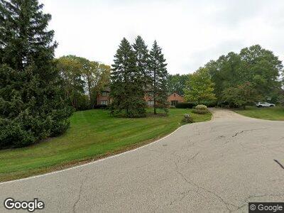
547 Saint Andrews Ln Inverness, IL 60067
Inverness NeighborhoodEstimated Value: $906,000 - $1,087,000
4
Beds
5
Baths
4,548
Sq Ft
$213/Sq Ft
Est. Value
About This Home
This home is located at 547 Saint Andrews Ln, Inverness, IL 60067 and is currently estimated at $969,939, approximately $213 per square foot. 547 Saint Andrews Ln is a home located in Cook County with nearby schools including Marion Jordan Elementary School, Walter R. Sundling Junior High School, and William Fremd High School.
Ownership History
Date
Name
Owned For
Owner Type
Purchase Details
Closed on
Jul 21, 2017
Sold by
Schmitt Timothy P and Schmitt Elaine L
Bought by
Schmitt Timothy P and The Timothy P Schmitt Revocable Living T
Current Estimated Value
Create a Home Valuation Report for This Property
The Home Valuation Report is an in-depth analysis detailing your home's value as well as a comparison with similar homes in the area
Home Values in the Area
Average Home Value in this Area
Purchase History
| Date | Buyer | Sale Price | Title Company |
|---|---|---|---|
| Schmitt Timothy P | -- | None Available |
Source: Public Records
Mortgage History
| Date | Status | Borrower | Loan Amount |
|---|---|---|---|
| Closed | Schmitt Timothy P | $128,010 | |
| Closed | Schmitt Timothy | $100,000 |
Source: Public Records
Tax History Compared to Growth
Tax History
| Year | Tax Paid | Tax Assessment Tax Assessment Total Assessment is a certain percentage of the fair market value that is determined by local assessors to be the total taxable value of land and additions on the property. | Land | Improvement |
|---|---|---|---|---|
| 2024 | $17,191 | $61,754 | $11,771 | $49,983 |
| 2023 | $17,191 | $61,754 | $11,771 | $49,983 |
| 2022 | $17,191 | $69,531 | $11,771 | $57,760 |
| 2021 | $17,549 | $63,878 | $7,847 | $56,031 |
| 2020 | $17,327 | $63,878 | $7,847 | $56,031 |
| 2019 | $17,870 | $73,702 | $7,847 | $65,855 |
| 2018 | $19,297 | $74,031 | $6,539 | $67,492 |
| 2017 | $20,122 | $78,397 | $6,539 | $71,858 |
| 2016 | $19,736 | $78,397 | $6,539 | $71,858 |
| 2015 | $19,227 | $70,553 | $9,155 | $61,398 |
| 2014 | $18,939 | $70,553 | $9,155 | $61,398 |
| 2013 | $18,382 | $70,553 | $9,155 | $61,398 |
Source: Public Records
Map
Nearby Homes
- 572 Glen Eagles Ct
- 134 Crichton Ln Unit 53
- 1056 W Willow St
- 228 N Clyde Ave
- 1213 W Northwest Hwy
- 1124 W Colfax St
- 667 N Morrison Ave
- 964 W Hidden Hills Ln
- 793 N Augustus Ct
- 671 N Maple Ave
- 385 N Chalary Ct
- 2201 Palatine Rd
- 644 N Franklin Ave
- 470 Inverway
- 1055 W Myrtle St
- 457 N Cambridge Dr Unit 457
- 1542 Durham Dr
- 1762 W Palatine Rd
- 886 W Palatine Rd
- 725 Milton Rd
- 547 Saint Andrews Ln
- 541 Saint Andrews Ln
- 553 Saint Andrews Ln
- 544 Rob Roy Ct
- 1281 Aberdeen Ln
- 540 Saint Andrews Ln
- 538 Rob Roy Ct
- 546 Saint Andrews Ln
- 552 Saint Andrews Ln
- 185 Rosslyn Ln Unit 136
- 189 Rosslyn Ln Unit 134
- 192 Old Wick Ln Unit 148
- 196 Glamis Ln Unit 133
- 194 Old Wick Ln Unit 149
- 1328 Aberdeen Ln
- 558 Saint Andrews Ln
- 183 Rosslyn Ln Unit 137
- 190 Old Wick Ln Unit 147
- 194 Glamis Ln Unit 132
- 543 Rob Roy Ct
