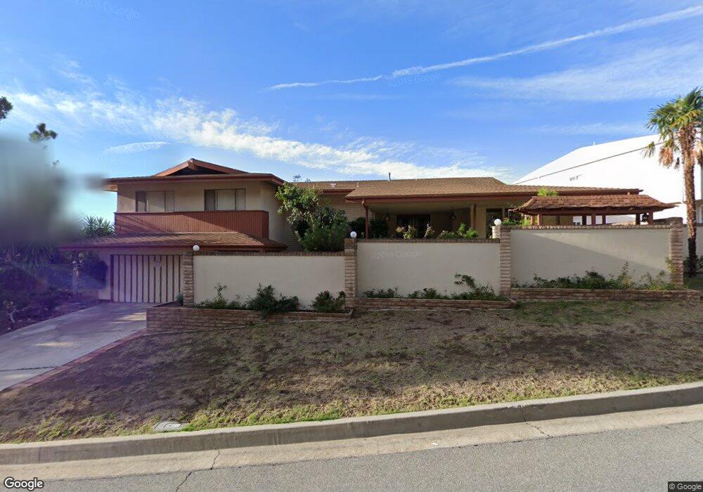
5475 Burning Tree Dr La Canada Flintridge, CA 91011
Estimated Value: $2,344,568 - $3,024,000
5
Beds
4
Baths
2,949
Sq Ft
$908/Sq Ft
Est. Value
About This Home
This home is located at 5475 Burning Tree Dr, La Canada Flintridge, CA 91011 and is currently estimated at $2,676,642, approximately $907 per square foot. 5475 Burning Tree Dr is a home located in Los Angeles County with nearby schools including Paradise Canyon Elementary School, La Canada High School, and La Canada Preparatory School.
Ownership History
Date
Name
Owned For
Owner Type
Purchase Details
Closed on
Oct 2, 1996
Sold by
Trust Meisen Walter And Veronica Trs Mei
Bought by
Au Mo Yin
Current Estimated Value
Purchase Details
Closed on
Sep 30, 1996
Sold by
Yu Shuk Ming
Bought by
Au Mo Yin
Purchase Details
Closed on
Oct 13, 1993
Sold by
Meisen Walter and Meisen Veronica
Bought by
Meisen Walter A and Meisen Veronica A
Create a Home Valuation Report for This Property
The Home Valuation Report is an in-depth analysis detailing your home's value as well as a comparison with similar homes in the area
Home Values in the Area
Average Home Value in this Area
Purchase History
| Date | Buyer | Sale Price | Title Company |
|---|---|---|---|
| Au Mo Yin | $575,000 | Southland Title Corporation | |
| Au Mo Yin | -- | Southland Title Corporation | |
| Meisen Walter A | -- | -- | |
| Meisen Walter | -- | -- |
Source: Public Records
Tax History
| Year | Tax Paid | Tax Assessment Tax Assessment Total Assessment is a certain percentage of the fair market value that is determined by local assessors to be the total taxable value of land and additions on the property. | Land | Improvement |
|---|---|---|---|---|
| 2025 | $11,092 | $936,481 | $439,901 | $496,580 |
| 2024 | $11,092 | $918,120 | $431,276 | $486,844 |
| 2023 | $10,817 | $900,119 | $422,820 | $477,299 |
| 2022 | $10,382 | $882,471 | $414,530 | $467,941 |
| 2021 | $10,321 | $865,168 | $406,402 | $458,766 |
| 2019 | $10,014 | $839,508 | $394,349 | $445,159 |
| 2018 | $9,729 | $823,048 | $386,617 | $436,431 |
| 2016 | $9,470 | $791,090 | $371,605 | $419,485 |
| 2015 | $9,446 | $779,208 | $366,024 | $413,184 |
| 2014 | $9,323 | $763,946 | $358,855 | $405,091 |
Source: Public Records
Map
Nearby Homes
- 411 Meadowview Dr
- 752 Galaxy Heights Dr
- 494 Paulette Place
- 767 Starlight Heights Dr
- 340 Santa Inez Way
- 5065 Indianola Way
- 832 Greenridge Dr
- 5748 Briartree Dr
- 358 San Juan Way
- 4487 Rising Hill Rd
- 3740 Canyon Crest Rd
- 4938 Angeles Crest Hwy
- 820 Millard Canyon Rd
- 941 Chehalem Rd
- 752 Via Arezzo Place
- 746 Via Arezzo Place
- 740 Via Arezzo Place
- 4428 Oakwood Ave
- 3903 Lilac Canyon Ln
- 3751 N Hollingsworth Rd
- 5467 Burning Tree Dr
- 5483 Burning Tree Dr
- 5455 Burning Tree Dr
- 5489 Burning Tree Dr
- 5451 Burning Tree Dr
- 5495 Burning Tree Dr
- 534 Starlight Crest Dr
- 544 Starlight Crest Dr
- 5441 Burning Tree Dr
- 502 Starlight Crest Dr
- 514 Starlight Crest Dr
- 550 Starlight Crest Dr
- 5503 Burning Tree Dr
- 494 Starlight Crest Dr
- 490 Starlight Crest Dr
- 560 Starlight Crest Dr
- 5435 Burning Tree Dr
- 5511 Burning Tree Dr
- 5429 Burning Tree Dr
- 568 Starlight Crest Dr
Your Personal Tour Guide
Ask me questions while you tour the home.