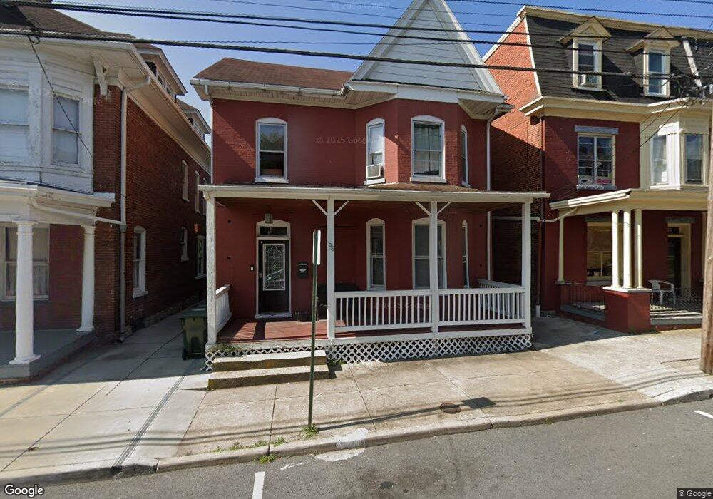
55 East Ave Hagerstown, MD 21740
Central NeighborhoodEstimated Value: $186,000 - $227,000
4
Beds
1
Bath
1,960
Sq Ft
$107/Sq Ft
Est. Value
About This Home
This home is located at 55 East Ave, Hagerstown, MD 21740 and is currently estimated at $208,781, approximately $106 per square foot. 55 East Ave is a home located in Washington County with nearby schools including Ruth Ann Monroe Primary School, Eastern Elementary School, and Otsego West Campus High School.
Ownership History
Date
Name
Owned For
Owner Type
Purchase Details
Closed on
Jun 25, 2012
Sold by
Gossard Cody W L
Bought by
Brunner Randall L
Current Estimated Value
Home Financials for this Owner
Home Financials are based on the most recent Mortgage that was taken out on this home.
Original Mortgage
$85,000
Outstanding Balance
$58,979
Interest Rate
3.78%
Mortgage Type
Purchase Money Mortgage
Estimated Equity
$149,802
Purchase Details
Closed on
May 17, 2010
Sold by
Hsbc Bank
Bought by
Gossard Cody W L
Purchase Details
Closed on
Feb 23, 2010
Sold by
Hadley Anita L and Hadley Donna L
Bought by
Bank Hsbc
Purchase Details
Closed on
Jul 19, 1999
Sold by
Pat Law W
Bought by
Hadley Anita L and Hadley Donna L
Create a Home Valuation Report for This Property
The Home Valuation Report is an in-depth analysis detailing your home's value as well as a comparison with similar homes in the area
Home Values in the Area
Average Home Value in this Area
Purchase History
| Date | Buyer | Sale Price | Title Company |
|---|---|---|---|
| Brunner Randall L | $85,000 | None Available | |
| Gossard Cody W L | $26,000 | -- | |
| Bank Hsbc | $72,865 | -- | |
| Hadley Anita L | $65,000 | -- |
Source: Public Records
Mortgage History
| Date | Status | Borrower | Loan Amount |
|---|---|---|---|
| Open | Brunner Randall L | $85,000 | |
| Closed | Hadley Anita L | -- |
Source: Public Records
Tax History Compared to Growth
Tax History
| Year | Tax Paid | Tax Assessment Tax Assessment Total Assessment is a certain percentage of the fair market value that is determined by local assessors to be the total taxable value of land and additions on the property. | Land | Improvement |
|---|---|---|---|---|
| 2025 | $1,483 | $185,500 | $31,300 | $154,200 |
| 2024 | $1,483 | $162,767 | $0 | $0 |
| 2023 | $1,276 | $140,033 | $0 | $0 |
| 2022 | $1,069 | $117,300 | $31,300 | $86,000 |
| 2021 | $977 | $111,133 | $0 | $0 |
| 2020 | $977 | $104,967 | $0 | $0 |
| 2019 | $924 | $98,800 | $31,300 | $67,500 |
| 2018 | $924 | $98,800 | $31,300 | $67,500 |
| 2017 | $924 | $98,800 | $0 | $0 |
| 2016 | -- | $104,000 | $0 | $0 |
| 2015 | -- | $103,200 | $0 | $0 |
| 2014 | $2,499 | $102,400 | $0 | $0 |
Source: Public Records
Map
Nearby Homes
- 227 N Locust St
- 115 East Ave
- 243 N Locust St
- 54 Randolph Ave
- 142 East Ave
- 207 N Mulberry St
- 308 N Locust St
- 133 Randolph Ave
- 200 E Franklin St
- 39 E North Ave
- 136 N Cannon Ave
- 25 S Locust St
- 409 N Mulberry St
- 409 411 N Mulberry St
- 51 N Cannon Ave
- 308 Jonathan St
- 312 E Franklin St
- 228 E Washington St
- 16 S Mulberry St
- 338 Liberty St