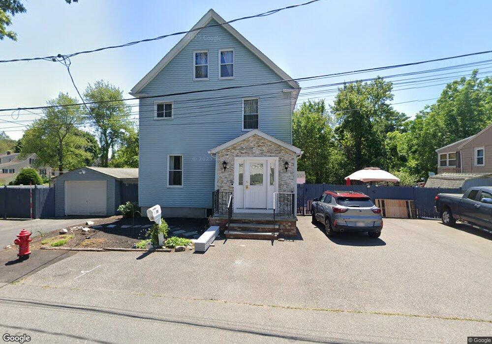
55 Magnolia St Saugus, MA 01906
Lynnhurst NeighborhoodEstimated Value: $695,073 - $842,000
4
Beds
2
Baths
2,268
Sq Ft
$343/Sq Ft
Est. Value
About This Home
This home is located at 55 Magnolia St, Saugus, MA 01906 and is currently estimated at $778,018, approximately $343 per square foot. 55 Magnolia St is a home located in Essex County with nearby schools including Saugus High School and Pioneer Charter School Of Science II.
Ownership History
Date
Name
Owned For
Owner Type
Purchase Details
Closed on
Jun 15, 2022
Sold by
Rescigno Corinne M and Rescigno John C
Bought by
John & Corinne 2022 Ret
Current Estimated Value
Purchase Details
Closed on
Jun 17, 1983
Bought by
Rescigno John C and Rescigno Corinne M
Create a Home Valuation Report for This Property
The Home Valuation Report is an in-depth analysis detailing your home's value as well as a comparison with similar homes in the area
Home Values in the Area
Average Home Value in this Area
Purchase History
| Date | Buyer | Sale Price | Title Company |
|---|---|---|---|
| John & Corinne 2022 Ret | -- | None Available | |
| Rescigno John C | -- | -- |
Source: Public Records
Mortgage History
| Date | Status | Borrower | Loan Amount |
|---|---|---|---|
| Previous Owner | Rescigno John C | $85,000 | |
| Previous Owner | Rescigno John C | $45,000 | |
| Previous Owner | Rescigno John C | $25,000 |
Source: Public Records
Tax History Compared to Growth
Tax History
| Year | Tax Paid | Tax Assessment Tax Assessment Total Assessment is a certain percentage of the fair market value that is determined by local assessors to be the total taxable value of land and additions on the property. | Land | Improvement |
|---|---|---|---|---|
| 2025 | $6,034 | $565,000 | $317,800 | $247,200 |
| 2024 | $5,785 | $543,200 | $299,600 | $243,600 |
| 2023 | $5,641 | $501,000 | $263,300 | $237,700 |
| 2022 | $5,633 | $469,000 | $241,500 | $227,500 |
| 2021 | $5,285 | $428,300 | $209,700 | $218,600 |
| 2020 | $4,887 | $410,000 | $199,800 | $210,200 |
| 2019 | $4,397 | $361,000 | $181,600 | $179,400 |
| 2018 | $3,999 | $345,300 | $176,200 | $169,100 |
| 2017 | $3,986 | $330,800 | $164,300 | $166,500 |
| 2016 | $3,579 | $293,400 | $164,100 | $129,300 |
| 2015 | $3,361 | $279,600 | $156,300 | $123,300 |
| 2014 | $3,290 | $283,400 | $156,300 | $127,100 |
Source: Public Records
Map
Nearby Homes
- 15 Appleton St
- 2 Mcintyre Rd
- 38 Appleton St
- 29 Susan Dr
- 7 Nirvana Dr
- 227 Walnut St
- 4 Oneil Way
- 10 Summer St
- 36 Jasper St
- 5 Hobson St
- 25 Auburn St
- 846 Broadway Unit 40
- 28 Emory St
- 9 Thomas St Unit 11
- 905 Sherwood Forest Ln
- 148 Forest St
- 32 Birch Brook Rd Unit 27
- 32 Birch Brook Rd Unit 16
- 32 Birch Brook Rd Unit 1
- 32 Birch Brook Rd Unit 25
- 49 Magnolia St
- 57 Magnolia St
- 54 Magnolia St
- 9 Evergreen St
- 47 Magnolia St
- 52 Magnolia St
- 16 Evergreen St
- 48 Magnolia St
- 25 Evergreen St
- 45 Magnolia St
- 18 Evergreen St
- 10 Evergreen St
- 5 Evergreen St
- 27 Evergreen St
- 22 Evergreen St
- 26 Evergreen St
- 6 Evergreen St
- 29 Desota St
- 60 Palmetto St
- 29 Evergreen St