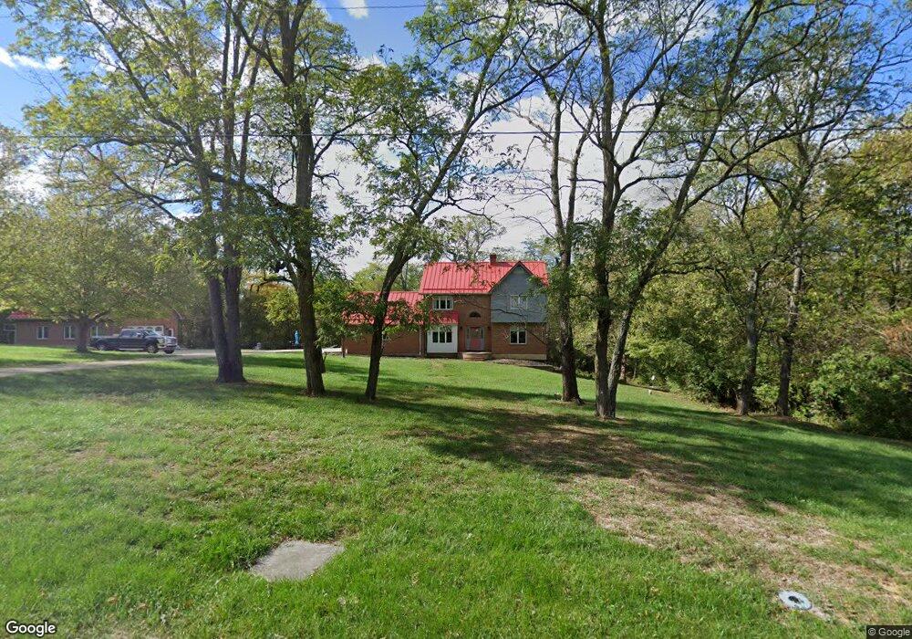
555 Upton Dr Independence, KY 41051
Estimated Value: $313,000 - $479,000
4
Beds
3
Baths
2,008
Sq Ft
$214/Sq Ft
Est. Value
About This Home
This home is located at 555 Upton Dr, Independence, KY 41051 and is currently estimated at $429,189, approximately $213 per square foot. 555 Upton Dr is a home located in Kenton County with nearby schools including Simon Kenton High School.
Ownership History
Date
Name
Owned For
Owner Type
Purchase Details
Closed on
Feb 7, 2024
Sold by
Behrens Michael L and Behrens Rita M
Bought by
Michael And Rita Behrens Living Trust and Behrens
Current Estimated Value
Purchase Details
Closed on
Dec 6, 2001
Sold by
Rabe David W
Bought by
Behrens Michael L and Behrens Rita M
Home Financials for this Owner
Home Financials are based on the most recent Mortgage that was taken out on this home.
Original Mortgage
$80,000
Interest Rate
6.6%
Mortgage Type
Balloon
Create a Home Valuation Report for This Property
The Home Valuation Report is an in-depth analysis detailing your home's value as well as a comparison with similar homes in the area
Home Values in the Area
Average Home Value in this Area
Purchase History
| Date | Buyer | Sale Price | Title Company |
|---|---|---|---|
| Michael And Rita Behrens Living Trust | $275,500 | None Listed On Document | |
| Behrens Michael L | $240,000 | -- |
Source: Public Records
Mortgage History
| Date | Status | Borrower | Loan Amount |
|---|---|---|---|
| Previous Owner | Behrens Michael L | $80,000 |
Source: Public Records
Tax History
| Year | Tax Paid | Tax Assessment Tax Assessment Total Assessment is a certain percentage of the fair market value that is determined by local assessors to be the total taxable value of land and additions on the property. | Land | Improvement |
|---|---|---|---|---|
| 2025 | $3,173 | $321,900 | $65,000 | $256,900 |
| 2024 | $3,375 | $321,900 | $65,000 | $256,900 |
| 2023 | $3,477 | $321,900 | $65,000 | $256,900 |
| 2022 | $3,605 | $321,900 | $65,000 | $256,900 |
| 2021 | $3,659 | $321,900 | $65,000 | $256,900 |
| 2020 | $2,998 | $264,000 | $55,000 | $209,000 |
| 2019 | $3,006 | $264,000 | $55,000 | $209,000 |
| 2018 | $3,045 | $264,000 | $55,000 | $209,000 |
| 2017 | $2,961 | $264,000 | $55,000 | $209,000 |
| 2015 | $2,888 | $264,000 | $85,000 | $179,000 |
| 2014 | $2,858 | $264,000 | $85,000 | $179,000 |
Source: Public Records
Map
Nearby Homes
- 1381 Poplartree Place
- 10213 Highmeadow Ln
- 1197 Catletts Ct
- 10362 Petersburg Ct
- 1247 Monocacy Ct
- 9877 Flagstone Dr
- 10008 Meadow Glen Dr
- 9971 Meadow Glen Dr
- 9980 Meadow Glen Dr
- 5220 Cody Rd
- 9964 Meadow Glen Dr
- 1217 Cannonball Way
- 10422 Flintrock Bluff
- 6500 Julia Meadow
- 1365 Cairns Ct
- 1202 Wellford Dr
- 10690 Melbury Ct Unit 305GL
- 1211 Wellford Dr
- 4102 Willowview Dr
- 4106 Willowview Dr
Your Personal Tour Guide
Ask me questions while you tour the home.