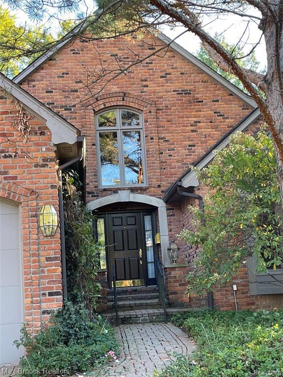
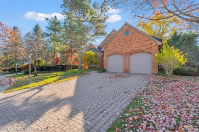
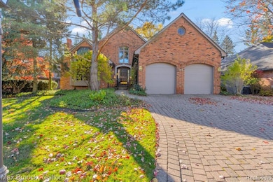
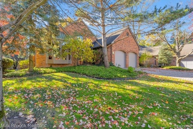
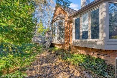
5554 Pine Brooke Ct Bloomfield Hills, MI 48304
Estimated payment $6,219/month
Highlights
- Built-In Refrigerator
- Colonial Architecture
- 2 Car Direct Access Garage
- Harlan Elementary School Rated A
- Deck
- Cul-De-Sac
About This Home
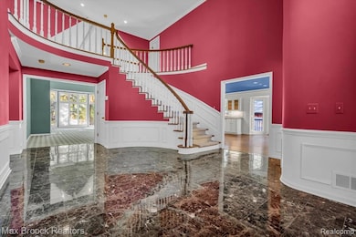
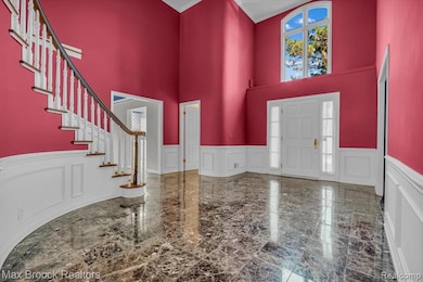
This detached condo is tucked away on a quiet cul-de-sac surrounded by mature trees. A grand 2 story marble foyer opens to a spacious living room with a vaulted ceiling. The paneled library/den is the perfect spot for cozy evenings in front of the fireplace. The oversized, all white kitchen is bright and inviting, featuring a breakfast nook that opens to a wrap around deck - ideal for summer entertaining. The dining room includes custom built-ins for storage and display. The first floor primary suite offers generous closet space and a private bath with dual vanities. upstairs two additional bedroom suites provide comfort and privacy. The finished lower level adds flexible living space and extra storage. Additional features include a generator, brick paver walkway and driveway. Just add your fnished touches and make this your home! BATVI
Listing Agent
Max Broock, REALTORS®-Birmingham License #6501225761 Listed on: 10/27/2025

Property Details
Home Type
- Condominium
Est. Annual Taxes
Year Built
- Built in 1987
HOA Fees
- $550 Monthly HOA Fees
Parking
- 2 Car Direct Access Garage
Home Design
- Colonial Architecture
- Brick Exterior Construction
- Poured Concrete
- Asphalt Roof
Interior Spaces
- 4,162 Sq Ft Home
- 2-Story Property
- Living Room with Fireplace
- Library with Fireplace
- Finished Basement
Kitchen
- Built-In Electric Range
- Built-In Refrigerator
- Dishwasher
- Disposal
Bedrooms and Bathrooms
- 3 Bedrooms
Laundry
- Dryer
- Washer
Outdoor Features
- Deck
- Exterior Lighting
Utilities
- Forced Air Heating System
- Heating System Uses Natural Gas
Additional Features
- Cul-De-Sac
- Ground Level
Listing and Financial Details
- Assessor Parcel Number 1925126042
Community Details
Overview
- Bill Abele Association, Phone Number (248) 765-0203
- Pinebrooke Manor Of Birm Occpn 442 Subdivision
Amenities
- Laundry Facilities
Pet Policy
- Pets Allowed
Map
Home Values in the Area
Average Home Value in this Area
Tax History
| Year | Tax Paid | Tax Assessment Tax Assessment Total Assessment is a certain percentage of the fair market value that is determined by local assessors to be the total taxable value of land and additions on the property. | Land | Improvement |
|---|---|---|---|---|
| 2024 | $6,094 | $388,070 | $0 | $0 |
| 2023 | $5,849 | $351,080 | $0 | $0 |
| 2022 | $9,900 | $346,920 | $0 | $0 |
| 2021 | $9,982 | $333,540 | $0 | $0 |
| 2020 | $5,618 | $325,290 | $0 | $0 |
| 2019 | $9,966 | $309,990 | $0 | $0 |
| 2018 | $9,891 | $294,760 | $0 | $0 |
| 2017 | $9,885 | $287,590 | $0 | $0 |
| 2016 | $9,939 | $312,520 | $0 | $0 |
| 2015 | -- | $312,320 | $0 | $0 |
| 2014 | -- | $231,710 | $0 | $0 |
| 2011 | -- | $244,510 | $0 | $0 |
Property History
| Date | Event | Price | List to Sale | Price per Sq Ft |
|---|---|---|---|---|
| 10/27/2025 10/27/25 | For Sale | $899,900 | -- | $216 / Sq Ft |
Purchase History
| Date | Type | Sale Price | Title Company |
|---|---|---|---|
| Quit Claim Deed | -- | None Listed On Document | |
| Interfamily Deed Transfer | -- | -- | |
| Deed | $570,000 | -- |
Mortgage History
| Date | Status | Loan Amount | Loan Type |
|---|---|---|---|
| Previous Owner | $456,000 | No Value Available |
Source: Realcomp
MLS Number: 20251049100
APN: 19-25-126-042
Disclaimer: Certain information contained herein is derived from information provided by parties other than Homes.com. All information provided is deemed reliable, but is not guaranteed to be accurate and should be independently verified.
![]() IDX provided courtesy of Realcomp II Ltd. via Ten-X and MLS
IDX provided courtesy of Realcomp II Ltd. via Ten-X and MLS
Copyright 2025 Realcomp II Ltd. Shareholders
IDX information is provided exclusively for consumers' personal, noncommercial use and may not be used for any purpose other than to identify prospective properties consumers may be interested in purchasing. The accuracy of all information, regardless of source, is not guaranteed or warranted. All information should be independently verified.
Listing Information presented by local MLS brokerage: Ten-X, local REALTOR®- Arlene Richardson - (888)-952-6393
- 1111 N Old Woodward Ave Unit 4
- 1111 N Old Woodward Ave Unit 26
- 1115 N Old Woodward #76 Ave
- 1115 N Old Woodward Ave Unit 52
- 1115 N Old Woodward Ave Unit 61
- 1330 Oxford Rd
- 1551 Lakeside Dr
- 0000 Brookdale Rd
- 1295 Lakeside Dr
- 1030 Lakeside Dr
- 667 Oak Ave
- 488 Vinewood Ave
- 654 Shepardbush St
- 680 Shepardbush St
- 639 N Old Woodward Ave Unit 8
- 750 Hazelwood St
- 1537 Ashford Ln
- 549 N Old Woodward Ave
- 485 Harmon St
- 777 Kensington Ln
- 36695 Woodward Ave
- 1111 N Old Woodward Ave Unit 1
- 1111 N Old Woodward Ave Unit 4
- 1115 N Old Woodward Ave Unit 55
- 1115 N Old Woodward Ave
- 1115 N Old Woodward Ave Unit 61
- 556 Bloomfield Ct
- 1047 N Old Woodward Ave Unit 4
- 1047 N Old Woodward Ave Unit 1
- 1047 N Old Woodward Ave
- 856 N Ave
- 856 N Old Woodward Unit 405 Ave
- 856 N Ave
- 856 N Old Woodward Ave Unit 306 Ave
- 856 N Old Woodward Unit 300 Ave Unit 300
- 856 N Old Woodward Ave Unit 202 Ave Unit 202
- 856 N Old Woodward Ave Unit 407 Ave Unit 407
- 856 N Old Woodward Ave Unit 208
- 856 N Old Woodward Ave Unit 204
- 573 N Old Woodward Ave Unit J573