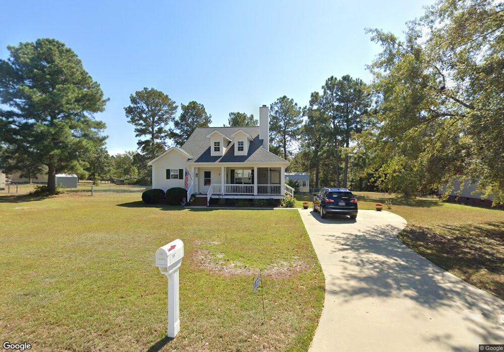
557 Railgate Loop Lugoff, SC 29078
Estimated Value: $211,000 - $244,000
3
Beds
1
Bath
1,286
Sq Ft
$175/Sq Ft
Est. Value
About This Home
This home is located at 557 Railgate Loop, Lugoff, SC 29078 and is currently estimated at $224,810, approximately $174 per square foot. 557 Railgate Loop is a home located in Kershaw County with nearby schools including Doby's Mill Elementary School, Leslie M. Stover Middle School, and Lugoff-Elgin High School.
Ownership History
Date
Name
Owned For
Owner Type
Purchase Details
Closed on
Aug 22, 2022
Sold by
Enger Nicole M
Bought by
Howard William and Howard Vicki Ann
Current Estimated Value
Home Financials for this Owner
Home Financials are based on the most recent Mortgage that was taken out on this home.
Original Mortgage
$198,850
Outstanding Balance
$189,523
Interest Rate
5.3%
Mortgage Type
New Conventional
Estimated Equity
$35,287
Purchase Details
Closed on
Jul 23, 2004
Sold by
Palmetto Enviromental Group
Bought by
Enger Nicole M
Purchase Details
Closed on
Feb 2, 2004
Sold by
Country Properties
Bought by
Palmetto Enviromental Group
Create a Home Valuation Report for This Property
The Home Valuation Report is an in-depth analysis detailing your home's value as well as a comparison with similar homes in the area
Purchase History
| Date | Buyer | Sale Price | Title Company |
|---|---|---|---|
| Howard William | $205,000 | None Listed On Document | |
| Enger Nicole M | $108,600 | -- | |
| Palmetto Enviromental Group | $16,000 | -- |
Source: Public Records
Mortgage History
| Date | Status | Borrower | Loan Amount |
|---|---|---|---|
| Open | Howard William | $198,850 |
Source: Public Records
Tax History
| Year | Tax Paid | Tax Assessment Tax Assessment Total Assessment is a certain percentage of the fair market value that is determined by local assessors to be the total taxable value of land and additions on the property. | Land | Improvement |
|---|---|---|---|---|
| 2025 | $1,030 | $205,000 | $20,000 | $185,000 |
| 2024 | $1,030 | $205,000 | $20,000 | $185,000 |
| 2023 | $1,432 | $205,000 | $20,000 | $185,000 |
| 2022 | $2,511 | $128,100 | $18,000 | $110,100 |
| 2021 | $2,453 | $128,100 | $18,000 | $110,100 |
| 2020 | $2,130 | $109,800 | $15,000 | $94,800 |
| 2019 | $2,153 | $109,800 | $15,000 | $94,800 |
| 2018 | $2,092 | $109,800 | $15,000 | $94,800 |
| 2017 | $2,069 | $109,800 | $15,000 | $94,800 |
| 2016 | $2,001 | $107,200 | $15,000 | $92,200 |
| 2015 | $1,708 | $107,200 | $15,000 | $92,200 |
| 2014 | $1,708 | $4,288 | $0 | $0 |
Source: Public Records
Map
Nearby Homes
- 48 Smokewood Dr
- 2011 Highway 1 S
- 1015 B Elgin Estates Dr
- 2140 Highway 1 S
- 23 Beechnut St Unit A
- 2206 Route 1
- 611 Finch Ct
- 605 Finch Ct
- 58 Driftwood Ave
- 12 Harvest Ct
- 8 Harvest Ct
- 55 Harvest Wheat Ct
- 64 Harvest Glen Dr
- 76 Driftwood Ave
- 2206 Highway 1 S
- 48 Harvest Wheat Ct
- 2349 Green Hill Rd
- 44 Harvest Wheat Ct
- 9 Harvest Ridge Dr
- 24 Harvest Moon Dr
- 553 Railgate Loop
- 569 Railgate Loop
- 549 Railgate Loop
- 597 Railgate Loop
- 558 Railgate Loop
- 554 Railgate Loop
- 599 Railgate Loop
- 575 Railgate Loop
- 562 Railgate Loop
- 583 Railgate Loop
- 545 Railgate Loop
- 572 Railgate Loop
- 550 Railgate Loop
- 546 Railgate Loop
- 605 Railgate Loop
- 566 Railgate Loop
- 570 Railgate Loop
- 576 Railgate Loop
- 541 Railgate Loop
- 611 Railgate Loop
Your Personal Tour Guide
Ask me questions while you tour the home.