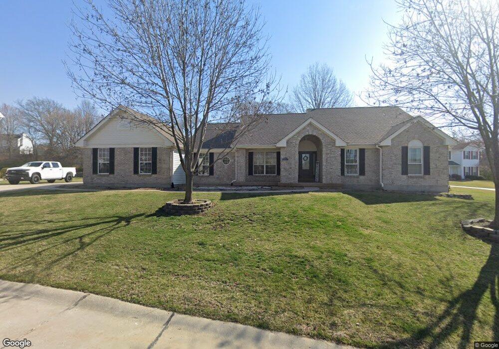
5571 Hennsley Cir Weldon Spring, MO 63304
Estimated Value: $480,000 - $520,000
3
Beds
3
Baths
2,146
Sq Ft
$233/Sq Ft
Est. Value
About This Home
This home is located at 5571 Hennsley Cir, Weldon Spring, MO 63304 and is currently estimated at $500,025, approximately $233 per square foot. 5571 Hennsley Cir is a home located in St. Charles County with nearby schools including Independence Elementary School, Francis Howell Middle School, and Francis Howell Union High School.
Ownership History
Date
Name
Owned For
Owner Type
Purchase Details
Closed on
Feb 4, 2025
Sold by
Shave Family Residence Trust and Shave Gregory Scott
Bought by
Shave Stuart Scott
Current Estimated Value
Purchase Details
Closed on
Dec 16, 2021
Sold by
Shave Kenneth L and Shave Edith N
Bought by
Kenneth L Shave And Edith N Shave Revocable L and Shave Family Residence Trust
Purchase Details
Closed on
Apr 23, 2013
Sold by
Shave Kenneth L and Shave Edith N
Bought by
The Kenneth L Shave & Edith N Shave Revo
Purchase Details
Closed on
May 24, 2002
Sold by
Shave Kenneth L and Shave Edith N
Bought by
Shave Kenneth L and Shave Edith N
Home Financials for this Owner
Home Financials are based on the most recent Mortgage that was taken out on this home.
Original Mortgage
$78,000
Interest Rate
6.89%
Create a Home Valuation Report for This Property
The Home Valuation Report is an in-depth analysis detailing your home's value as well as a comparison with similar homes in the area
Home Values in the Area
Average Home Value in this Area
Purchase History
| Date | Buyer | Sale Price | Title Company |
|---|---|---|---|
| Shave Stuart Scott | -- | None Listed On Document | |
| Kenneth L Shave And Edith N Shave Revocable L | -- | None Listed On Document | |
| The Kenneth L Shave & Edith N Shave Revo | -- | None Available | |
| Shave Kenneth L | -- | -- | |
| Shave Kenneth L | -- | -- |
Source: Public Records
Mortgage History
| Date | Status | Borrower | Loan Amount |
|---|---|---|---|
| Previous Owner | Shave Kenneth L | $78,000 |
Source: Public Records
Tax History
| Year | Tax Paid | Tax Assessment Tax Assessment Total Assessment is a certain percentage of the fair market value that is determined by local assessors to be the total taxable value of land and additions on the property. | Land | Improvement |
|---|---|---|---|---|
| 2025 | $4,490 | $82,121 | -- | -- |
| 2023 | $4,488 | $75,253 | -- | -- |
| 2022 | $4,167 | $64,906 | $0 | $0 |
| 2021 | $4,171 | $64,906 | $0 | $0 |
| 2020 | $4,070 | $61,304 | $0 | $0 |
| 2019 | $4,052 | $61,304 | $0 | $0 |
| 2018 | $4,232 | $61,245 | $0 | $0 |
| 2017 | $4,198 | $61,245 | $0 | $0 |
| 2016 | $3,765 | $52,881 | $0 | $0 |
| 2015 | $3,730 | $52,881 | $0 | $0 |
| 2014 | $3,575 | $49,176 | $0 | $0 |
Source: Public Records
Map
Nearby Homes
- 5527 Hennsley Cir
- 5534 Wavecrest Cir
- 0 Gutermuth Rd
- 14 Walnut Hill Ct
- 323 Wildberry Ln
- 828 Nancy Ln
- 102 Enclave Terrace Ct
- 0 Universal Design Prairie Bluff Unit MAR24041208
- 217 Bottlebrush Grove Ct
- 1317 Auburn Hills Dr
- 301 Switchgrass Landing Ln
- 1 Belcourt Cir
- 114 Cottle Creek Way
- 106 Cottle Creek Way
- 110 Cottle Creek Way
- 1334 Auburn Hills Dr
- 116 Cottle Creek Way
- 1005 Waldo Ln
- 136 Sweetgrass Point Way
- 3009 Bruce Trail Ct
- 5567 Hennsley Cir
- 5575 E Hennsley Circle Ct
- 5548 Meadowgreen Ct
- 5544 Meadowgreen Ct
- 5563 Hennsley Cir
- 5579 E Hennsley Circle Ct
- 5540 Meadowgreen Ct
- 5578 Hennsley Cir
- 5583 E Hennsley Circle Ct
- 5568 Hennsley Cir
- 5552 Meadowgreen Ct
- 5536 Meadowgreen Ct
- 5559 Hennsley Cir
- 5585 Hennsley Cir
- 5558 Hennsley Cir
- 5532 Meadowgreen Ct
- 5587 Hennsley Cir
- 5588 Hennsley Cir
- 5549 Meadowgreen Ct
- 5587 Jade Tree Dr
Your Personal Tour Guide
Ask me questions while you tour the home.