Estimated Value: $350,000 - $551,000
4
Beds
4
Baths
1,850
Sq Ft
$250/Sq Ft
Est. Value
About This Home
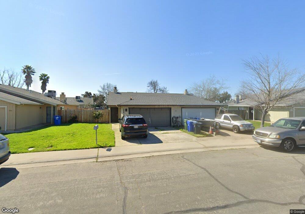
This home is located at 558 Ron Way, Galt, CA 95632 and is currently estimated at $462,806, approximately $250 per square foot. 558 Ron Way is a home located in Sacramento County with nearby schools including River Oaks Elementary School, Robert L. McCaffrey Middle School, and Galt High School.
Ownership History
Date
Name
Owned For
Owner Type
Purchase Details
Closed on
Mar 7, 2017
Sold by
Huan Haiyan
Bought by
Martin Scott
Current Estimated Value
Purchase Details
Closed on
Jun 23, 2011
Sold by
Dehart Linda A
Bought by
Dehart Linda A and Linda A Dehart 2011 Living Tru
Purchase Details
Closed on
Oct 7, 1999
Sold by
Dehart Dennis G and Dehart Linda A
Bought by
Dehart Dennis G and Dehart Linda A
Purchase Details
Closed on
Mar 9, 1994
Sold by
Brubaker Diane
Bought by
Brubaker Jack
Home Financials for this Owner
Home Financials are based on the most recent Mortgage that was taken out on this home.
Original Mortgage
$76,000
Interest Rate
7%
Create a Home Valuation Report for This Property
The Home Valuation Report is an in-depth analysis detailing your home's value as well as a comparison with similar homes in the area
Home Values in the Area
Average Home Value in this Area
Purchase History
| Date | Buyer | Sale Price | Title Company |
|---|---|---|---|
| Martin Scott | -- | Chicago Title Company | |
| Martin Scott | $259,000 | Chicago Title Company | |
| Dehart Linda A | -- | None Available | |
| Dehart Dennis G | -- | -- | |
| Brubaker Jack | -- | -- |
Source: Public Records
Mortgage History
| Date | Status | Borrower | Loan Amount |
|---|---|---|---|
| Previous Owner | Brubaker Jack | $76,000 |
Source: Public Records
Tax History Compared to Growth
Tax History
| Year | Tax Paid | Tax Assessment Tax Assessment Total Assessment is a certain percentage of the fair market value that is determined by local assessors to be the total taxable value of land and additions on the property. | Land | Improvement |
|---|---|---|---|---|
| 2025 | $3,308 | $300,585 | $90,175 | $210,410 |
| 2024 | $3,308 | $294,692 | $88,407 | $206,285 |
| 2023 | $3,252 | $288,915 | $86,674 | $202,241 |
| 2022 | $3,121 | $283,251 | $84,975 | $198,276 |
| 2021 | $3,125 | $277,698 | $83,309 | $194,389 |
| 2020 | $3,099 | $274,851 | $82,455 | $192,396 |
| 2019 | $3,022 | $269,463 | $80,839 | $188,624 |
| 2018 | $3,017 | $264,180 | $79,254 | $184,926 |
| 2017 | $1,809 | $161,643 | $22,937 | $138,706 |
| 2016 | $1,738 | $158,475 | $22,488 | $135,987 |
| 2015 | $1,679 | $156,096 | $22,151 | $133,945 |
| 2014 | $1,674 | $153,040 | $21,718 | $131,322 |
Source: Public Records
Map
Nearby Homes
- 409 N Lincoln Way
- 650 Nathaniel Ave
- 604 Pringle Ave Unit 94
- 604 Pringle Ave Unit 99
- 604 Pringle Ave Unit 121
- 604 Pringle Ave Unit 87
- 605 Pringle Ave Unit 41
- 605 Pringle Ave Unit 9
- 350 Palin Ave
- 820 N Lincoln Way Unit 73
- 820 N Lincoln Way Unit 42
- 820 N Lincoln Way Unit 78
- 809 Ashboro Ln
- 10183 Pringle Ave
- 326 Oak Ave
- 933 Colson Ct
- 956 Trafalgar Cir
- 0 Pringle Ave Unit 225089282
- 0 Pringle Ave Unit 225119777
- 663 Canyon Creek Way