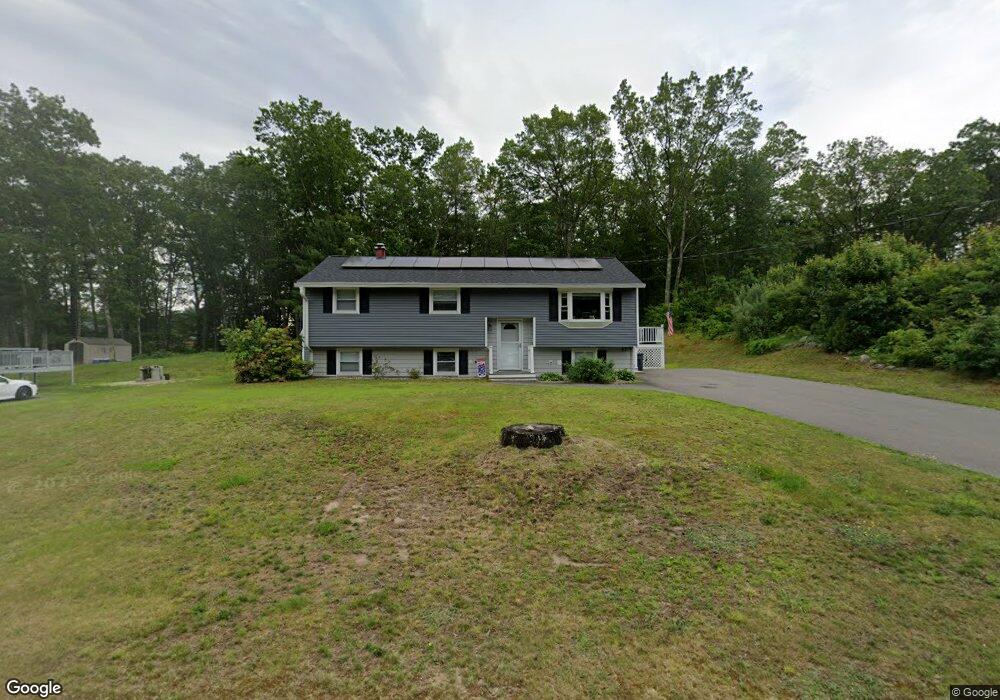
56 Belmont Dr Merrimack, NH 03054
Estimated Value: $455,818 - $478,000
3
Beds
1
Bath
1,088
Sq Ft
$426/Sq Ft
Est. Value
About This Home
This home is located at 56 Belmont Dr, Merrimack, NH 03054 and is currently estimated at $463,705, approximately $426 per square foot. 56 Belmont Dr is a home located in Hillsborough County with nearby schools including Reeds Ferry School, James Mastricola Upper Elementary School, and Merrimack Middle School.
Ownership History
Date
Name
Owned For
Owner Type
Purchase Details
Closed on
Aug 27, 2008
Sold by
Wells Fargo Bank Na
Bought by
Plouffe Normand G and Plouffe Tabitha M
Current Estimated Value
Home Financials for this Owner
Home Financials are based on the most recent Mortgage that was taken out on this home.
Original Mortgage
$207,774
Interest Rate
6.29%
Mortgage Type
Purchase Money Mortgage
Purchase Details
Closed on
Mar 26, 2008
Sold by
Yuksel Boris
Bought by
Wells Fargo Bank Na
Purchase Details
Closed on
May 2, 2005
Sold by
Mabon Christopher B and Mabon Melanie
Bought by
Yuksel Boris
Purchase Details
Closed on
Feb 28, 2003
Sold by
Verrington James H
Bought by
Mabon Christopher B and Mabon Melanie
Purchase Details
Closed on
Nov 26, 1996
Sold by
Seph Rlty Inc
Bought by
Verrington James H
Purchase Details
Closed on
Jul 3, 1996
Sold by
Luebke Raymond L and Luebke Kathryn M
Bought by
Poirier Edmund
Create a Home Valuation Report for This Property
The Home Valuation Report is an in-depth analysis detailing your home's value as well as a comparison with similar homes in the area
Home Values in the Area
Average Home Value in this Area
Purchase History
| Date | Buyer | Sale Price | Title Company |
|---|---|---|---|
| Plouffe Normand G | $210,000 | -- | |
| Wells Fargo Bank Na | $201,500 | -- | |
| Yuksel Boris | $240,000 | -- | |
| Mabon Christopher B | $204,000 | -- | |
| Verrington James H | $96,300 | -- | |
| Poirier Edmund | $56,500 | -- |
Source: Public Records
Mortgage History
| Date | Status | Borrower | Loan Amount |
|---|---|---|---|
| Open | Poirier Edmund | $218,225 | |
| Closed | Poirier Edmund | $207,774 |
Source: Public Records
Tax History Compared to Growth
Tax History
| Year | Tax Paid | Tax Assessment Tax Assessment Total Assessment is a certain percentage of the fair market value that is determined by local assessors to be the total taxable value of land and additions on the property. | Land | Improvement |
|---|---|---|---|---|
| 2024 | $7,074 | $341,900 | $194,100 | $147,800 |
| 2023 | $6,650 | $341,900 | $194,100 | $147,800 |
| 2022 | $5,775 | $332,300 | $194,100 | $138,200 |
| 2021 | $5,706 | $332,300 | $194,100 | $138,200 |
| 2020 | $5,630 | $234,000 | $134,000 | $100,000 |
| 2019 | $5,381 | $223,000 | $134,000 | $89,000 |
| 2018 | $5,379 | $223,000 | $134,000 | $89,000 |
| 2017 | $5,209 | $222,900 | $134,000 | $88,900 |
| 2016 | $5,080 | $222,900 | $134,000 | $88,900 |
| 2015 | $4,887 | $197,700 | $122,100 | $75,600 |
| 2014 | $4,763 | $197,700 | $122,100 | $75,600 |
| 2013 | $4,727 | $197,700 | $122,100 | $75,600 |
Source: Public Records
Map
Nearby Homes
- 29 Bedford Rd
- 22 Kimberly Dr
- 5 Barbie Ct
- 1 Pleasant St
- 19 Vista Way
- 38 Mallard Point
- 9 Mustang Dr Unit C
- 9 Mustang Dr Unit B
- 7 Mustang Dr Unit C
- 7 Mustang Dr Unit END UNIT-A
- 490 Charles Bancroft Hwy
- 3-C Mustang Dr Unit MODEL
- 10 Kingston Ct Unit 10
- 11 Essex Green Ct
- 22 Essex Green Ct
- 12 Clinton Ct
- 18 Horizon Dr
- 769 Daniel Webster Hwy
- 29 Watts Landing Unit 24
- 22 Clay St