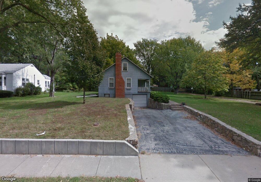
5605 Flint St Shawnee, KS 66203
Estimated Value: $256,000 - $315,000
3
Beds
1
Bath
1,146
Sq Ft
$252/Sq Ft
Est. Value
About This Home
This home is located at 5605 Flint St, Shawnee, KS 66203 and is currently estimated at $289,203, approximately $252 per square foot. 5605 Flint St is a home located in Johnson County with nearby schools including Bluejacket / Flint Elementary, Hocker Grove Middle School, and Shawnee Mission North High School.
Ownership History
Date
Name
Owned For
Owner Type
Purchase Details
Closed on
Jan 14, 2008
Sold by
Smith Larry A and Smith Betty Ruth
Bought by
Smith Larry A and Smith Betty R
Current Estimated Value
Home Financials for this Owner
Home Financials are based on the most recent Mortgage that was taken out on this home.
Original Mortgage
$114,000
Interest Rate
5.94%
Mortgage Type
New Conventional
Create a Home Valuation Report for This Property
The Home Valuation Report is an in-depth analysis detailing your home's value as well as a comparison with similar homes in the area
Home Values in the Area
Average Home Value in this Area
Purchase History
| Date | Buyer | Sale Price | Title Company |
|---|---|---|---|
| Smith Larry A | -- | Chicago Title Ins Co |
Source: Public Records
Mortgage History
| Date | Status | Borrower | Loan Amount |
|---|---|---|---|
| Closed | Smith Larry A | $114,000 |
Source: Public Records
Tax History
| Year | Tax Paid | Tax Assessment Tax Assessment Total Assessment is a certain percentage of the fair market value that is determined by local assessors to be the total taxable value of land and additions on the property. | Land | Improvement |
|---|---|---|---|---|
| 2025 | $2,861 | $28,014 | $7,439 | $20,575 |
| 2023 | $2,700 | $25,265 | $7,439 | $17,826 |
| 2022 | $2,622 | $24,426 | $6,754 | $17,672 |
| 2021 | $2,345 | $20,367 | $5,864 | $14,503 |
| 2020 | $2,102 | $17,997 | $5,339 | $12,658 |
| 2019 | $2,139 | $18,308 | $4,449 | $13,859 |
| 2018 | $1,947 | $16,583 | $4,039 | $12,544 |
| 2017 | $1,906 | $15,985 | $4,039 | $11,946 |
| 2016 | $1,739 | $14,375 | $4,039 | $10,336 |
| 2015 | $1,632 | $14,134 | $4,039 | $10,095 |
| 2013 | -- | $13,202 | $4,039 | $9,163 |
Source: Public Records
Map
Nearby Homes
- 5435 Flint St
- 11009 W 56th Terrace
- 11000 W 56th Terrace
- 5734 Cody St
- 5308 Mcanany Dr
- 11700 Johnson Dr
- 12027 W 58th Place Unit B
- 5952 Garnett St
- 6009 Earnshaw St
- 13126 W 52nd Terrace
- 13134 W 52nd Terrace
- 13130 W 52nd Terrace
- 5711 Westgate St
- 10116 W 52nd Terrace
- 10702 W 49th Place
- 11907 W 49th Place
- 10511 W 49th Place
- 5719 Farley St
- 5841 Blackhoof Trail
- 6404 Ballentine St