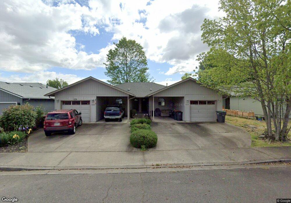
564 Countryside Dr Central Point, OR 97502
Estimated Value: $438,118 - $516,000
4
Beds
4
Baths
2,190
Sq Ft
$219/Sq Ft
Est. Value
About This Home
This home is located at 564 Countryside Dr, Central Point, OR 97502 and is currently estimated at $478,530, approximately $218 per square foot. 564 Countryside Dr is a home located in Jackson County with nearby schools including Central Point Elementary School, Scenic Middle School, and Crater High School.
Ownership History
Date
Name
Owned For
Owner Type
Purchase Details
Closed on
Jul 27, 2015
Sold by
Gillett James and Gillett Lawrence
Bought by
Gillett James D and The James D Gillett Living Trust
Current Estimated Value
Purchase Details
Closed on
Jul 26, 2000
Sold by
Slaughter Joel P
Bought by
Champagne Leo J and Champagne Nancy G
Create a Home Valuation Report for This Property
The Home Valuation Report is an in-depth analysis detailing your home's value as well as a comparison with similar homes in the area
Home Values in the Area
Average Home Value in this Area
Purchase History
| Date | Buyer | Sale Price | Title Company |
|---|---|---|---|
| Gillett James D | -- | None Available | |
| Champagne Leo J | -- | Amerititle |
Source: Public Records
Tax History Compared to Growth
Tax History
| Year | Tax Paid | Tax Assessment Tax Assessment Total Assessment is a certain percentage of the fair market value that is determined by local assessors to be the total taxable value of land and additions on the property. | Land | Improvement |
|---|---|---|---|---|
| 2025 | $4,248 | $255,520 | $73,820 | $181,700 |
| 2024 | $4,248 | $248,080 | $71,670 | $176,410 |
| 2023 | $4,112 | $240,860 | $69,580 | $171,280 |
| 2022 | $4,016 | $240,860 | $69,580 | $171,280 |
| 2021 | $3,901 | $233,850 | $67,550 | $166,300 |
| 2020 | $3,787 | $227,040 | $65,580 | $161,460 |
| 2019 | $3,694 | $214,010 | $61,820 | $152,190 |
| 2018 | $3,581 | $207,780 | $60,020 | $147,760 |
| 2017 | $3,491 | $207,780 | $60,020 | $147,760 |
| 2016 | $3,389 | $195,860 | $56,580 | $139,280 |
| 2015 | $3,247 | $195,860 | $56,580 | $139,280 |
| 2014 | $3,165 | $184,630 | $53,340 | $131,290 |
Source: Public Records
Map
Nearby Homes
- 571 Briarwood Dr
- 851 Juanita Way
- 928 Brandi Way
- 301 Freeman Rd Unit 100
- 301 Freeman Rd Unit 23
- 301 Freeman Rd Unit 85
- 555 Freeman Rd Unit 128
- 555 Freeman Rd Unit 146
- 555 Freeman Rd Unit 204
- 555 Freeman Rd Unit 209
- 921 Pittview Ave
- 1060 Hopkins Rd
- 3496 Edella St
- 230 Peninger Rd
- 1017 Fairfield Ave
- 1025 Fairfield Ave
- 840 Ash St
- 531 Bush St
- 340 Freeman Rd
- 755 S 4th St
- 562 Countryside Dr
- 542 Countryside Dr
- 544 Countryside Dr
- 572 Countryside Dr
- 0 Countryside Dr
- 563 Primrose Dr
- 543 Primrose Dr
- 573 Primrose Dr
- 582 Countryside Dr
- 532 Countryside Dr Unit 534
- 561 Countryside Dr
- 565 Countryside Dr
- 533 Primrose Dr
- 583 Primrose Dr
- 531 Countryside Dr
- 522 Countryside Dr
- 859 Hopkins Rd
- 581 Countryside Dr
- 523 Primrose Dr
- 865 Hopkins Rd