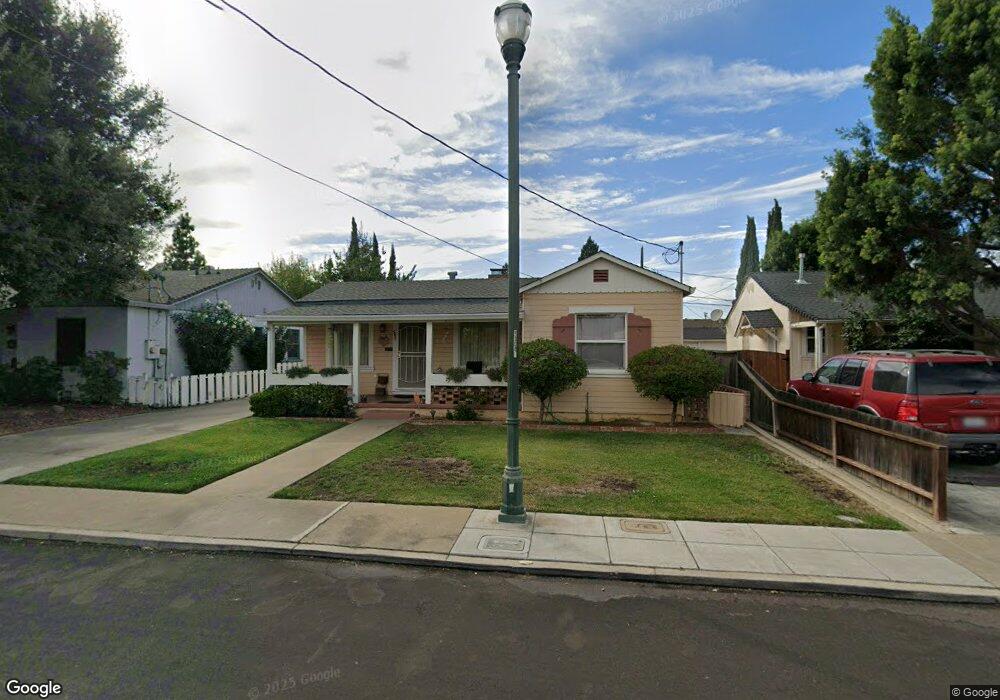
569 Rutland Ave San Jose, CA 95128
Buena Vista NeighborhoodEstimated Value: $998,000 - $1,184,000
2
Beds
1
Bath
908
Sq Ft
$1,223/Sq Ft
Est. Value
About This Home
This home is located at 569 Rutland Ave, San Jose, CA 95128 and is currently estimated at $1,110,803, approximately $1,223 per square foot. 569 Rutland Ave is a home located in Santa Clara County with nearby schools including Del Mar High School, Sherman Oaks Elementary School, and Monroe Middle School.
Ownership History
Date
Name
Owned For
Owner Type
Purchase Details
Closed on
Mar 11, 2019
Sold by
Pistello Susan and Pistello Susan Lynn
Bought by
Pistello Susan Lynn and Susan Lynn Pistello Living Tru
Current Estimated Value
Purchase Details
Closed on
Aug 17, 2016
Sold by
Pistello Susan
Bought by
Pistello Susan
Purchase Details
Closed on
Apr 13, 2000
Sold by
Pistello Antonio J
Bought by
The Pistello Family Trust
Create a Home Valuation Report for This Property
The Home Valuation Report is an in-depth analysis detailing your home's value as well as a comparison with similar homes in the area
Home Values in the Area
Average Home Value in this Area
Purchase History
| Date | Buyer | Sale Price | Title Company |
|---|---|---|---|
| Pistello Susan Lynn | -- | None Available | |
| Pistello Susan | -- | None Available | |
| The Pistello Family Trust | -- | -- | |
| Pistello Antonio John | -- | -- |
Source: Public Records
Tax History Compared to Growth
Tax History
| Year | Tax Paid | Tax Assessment Tax Assessment Total Assessment is a certain percentage of the fair market value that is determined by local assessors to be the total taxable value of land and additions on the property. | Land | Improvement |
|---|---|---|---|---|
| 2025 | $1,865 | $55,614 | $23,297 | $32,317 |
| 2024 | $1,865 | $54,525 | $22,841 | $31,684 |
| 2023 | $1,852 | $53,457 | $22,394 | $31,063 |
| 2022 | $1,903 | $52,409 | $21,955 | $30,454 |
| 2021 | $1,891 | $51,382 | $21,525 | $29,857 |
| 2020 | $1,875 | $50,856 | $21,305 | $29,551 |
| 2019 | $1,797 | $49,860 | $20,888 | $28,972 |
| 2018 | $1,658 | $48,883 | $20,479 | $28,404 |
| 2017 | $1,543 | $47,926 | $20,078 | $27,848 |
| 2016 | $1,407 | $46,987 | $19,685 | $27,302 |
| 2015 | $1,317 | $46,282 | $19,390 | $26,892 |
| 2014 | $1,163 | $45,377 | $19,011 | $26,366 |
Source: Public Records
Map
Nearby Homes
- 530 Irving Ave
- 553 Irving Ave
- 439 Leland Ave
- 0 Menker Ave
- 509 Laswell Ave
- 692 Menker Ave
- 418 Vaughn Ave Unit 1 & 2
- 406 Menker Ave
- 323 Rutland Ave
- 325 Irving Ave
- 501 S Bascom Ave
- 1828 W San Carlos St
- 800 Leigh Ave
- 785 Richmond Ave
- 0 N Bascom Ave
- 482 S Willard Ave
- 803 Corlista Dr
- 584 Macarthur Ave
- 540 Page St
- 2469 Olive Ave
- 573 Rutland Ave
- 563 Rutland Ave
- 559 Rutland Ave
- 566 Leland Ave
- 572 Leland Ave
- 558 Leland Ave
- 553 Rutland Ave
- 570 Rutland Ave
- 564 Rutland Ave
- 574 Rutland Ave
- 552 Leland Ave
- 560 Rutland Ave
- 554 Rutland Ave
- 565 Leland Ave
- 569 Clifton Ave
- 571 Leland Ave
- 547 Rutland Ave
- 573 Clifton Ave
- 563 Clifton Ave
- 557 Leland Ave