Estimated Value: $403,375 - $422,000
4
Beds
3
Baths
2,450
Sq Ft
$169/Sq Ft
Est. Value
About This Home
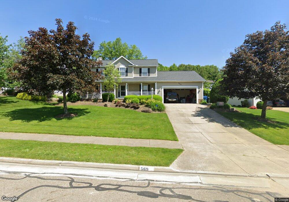
This home is located at 569 Wrens Path, Akron, OH 44319 and is currently estimated at $412,844, approximately $168 per square foot. 569 Wrens Path is a home located in Summit County with nearby schools including Greenwood Elementary School, Green Intermediate Elementary School, and Green Primary School.
Ownership History
Date
Name
Owned For
Owner Type
Purchase Details
Closed on
Feb 18, 2010
Sold by
Mossop Daniel Patrick and Mossop Vanessa N
Bought by
Parrish Edmund J
Current Estimated Value
Home Financials for this Owner
Home Financials are based on the most recent Mortgage that was taken out on this home.
Original Mortgage
$187,475
Interest Rate
5.25%
Mortgage Type
FHA
Purchase Details
Closed on
Jun 26, 1998
Sold by
Mellon D Todd
Bought by
Kmiecik Ii Richard J Karen E
Home Financials for this Owner
Home Financials are based on the most recent Mortgage that was taken out on this home.
Original Mortgage
$165,700
Interest Rate
7.27%
Mortgage Type
New Conventional
Purchase Details
Closed on
May 18, 1995
Sold by
Robinhood Dev Ltd
Bought by
Greenbriar Homes Inc
Create a Home Valuation Report for This Property
The Home Valuation Report is an in-depth analysis detailing your home's value as well as a comparison with similar homes in the area
Home Values in the Area
Average Home Value in this Area
Purchase History
| Date | Buyer | Sale Price | Title Company |
|---|---|---|---|
| Parrish Edmund J | $190,000 | Stewart Title Guaranty Compa | |
| Kmiecik Ii Richard J Karen E | $195,000 | -- | |
| Greenbriar Homes Inc | $38,000 | -- |
Source: Public Records
Mortgage History
| Date | Status | Borrower | Loan Amount |
|---|---|---|---|
| Previous Owner | Parrish Edmund J | $187,475 | |
| Previous Owner | Kmiecik Ii Richard J Karen E | $165,700 |
Source: Public Records
Tax History Compared to Growth
Tax History
| Year | Tax Paid | Tax Assessment Tax Assessment Total Assessment is a certain percentage of the fair market value that is determined by local assessors to be the total taxable value of land and additions on the property. | Land | Improvement |
|---|---|---|---|---|
| 2025 | $6,337 | $116,074 | $21,266 | $94,808 |
| 2024 | $6,337 | $116,074 | $21,266 | $94,808 |
| 2023 | $6,337 | $116,074 | $21,266 | $94,808 |
| 2022 | $5,282 | $84,228 | $15,411 | $68,817 |
| 2021 | $4,203 | $84,228 | $15,411 | $68,817 |
| 2020 | $4,924 | $84,230 | $15,410 | $68,820 |
| 2019 | $4,891 | $78,280 | $14,950 | $63,330 |
| 2018 | $4,981 | $78,280 | $14,950 | $63,330 |
| 2017 | $4,727 | $78,280 | $14,950 | $63,330 |
| 2016 | $4,601 | $67,320 | $14,950 | $52,370 |
| 2015 | $4,727 | $67,320 | $14,950 | $52,370 |
| 2014 | $4,700 | $67,320 | $14,950 | $52,370 |
| 2013 | $4,621 | $65,560 | $14,950 | $50,610 |
Source: Public Records
Map
Nearby Homes
- 652 Bobwhite Trail
- 3113 Sparrows Crest
- 399 Abbyshire Rd
- 435 Bonshire Rd
- 341 Abbyshire Rd
- 3145 Daisy Ave
- 0 Bayview Terrace
- 0 Fortuna Dr Unit 5005346
- 3845 Cayugas Dr
- 111 Magua Dr
- 960 Impala Dr
- 3785 S Main St
- 1096 Cookhill Cir Unit 50
- TBD Heron Watch Dr
- 0 Sandy Beach Dr
- 652 S Sheraton Dr
- 3870 S Main St
- 1188 Cookhill Cir Unit 21
- 1254 Maxfli Dr
- 583 Knollwood Dr
- 577 Wrens Path
- 561 Wrens Path
- 568 Jarvis Rd
- 585 Wrens Path
- 560 Jarvis Rd
- 551 Wrens Path
- 576 Jarvis Rd
- 3080 Snowgoose Ln
- 3053 Sparrows Crest
- 582 Wrens Path
- 584 Jarvis Rd
- 593 Wrens Path
- 552 Wrens Path
- 3090 Snowgoose Ln
- 592 Jarvis Rd
- 3272 Doubler Dr
- 601 Wrens Path
- 3089 Sparrows Crest
- 3060 Sparrows Crest
- 3068 Sparrows Crest