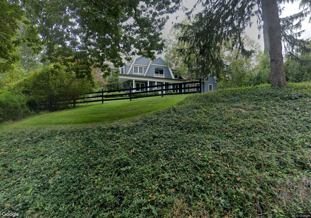
57 Muhlenbrink Rd Colts Neck, NJ 07722
Estimated Value: $1,596,000 - $2,182,000
3
Beds
2
Baths
4,048
Sq Ft
$443/Sq Ft
Est. Value
About This Home
This home is located at 57 Muhlenbrink Rd, Colts Neck, NJ 07722 and is currently estimated at $1,791,929, approximately $442 per square foot. 57 Muhlenbrink Rd is a home located in Monmouth County with nearby schools including Conover Road School, Cedar Drive Middle School, and Colts Neck High School.
Ownership History
Date
Name
Owned For
Owner Type
Purchase Details
Closed on
Feb 21, 2008
Sold by
Maver Glenn A and Maver Nancy E
Bought by
Yale Kevin S and Yale Melanie
Current Estimated Value
Home Financials for this Owner
Home Financials are based on the most recent Mortgage that was taken out on this home.
Original Mortgage
$64,000
Interest Rate
5.8%
Mortgage Type
Credit Line Revolving
Create a Home Valuation Report for This Property
The Home Valuation Report is an in-depth analysis detailing your home's value as well as a comparison with similar homes in the area
Home Values in the Area
Average Home Value in this Area
Purchase History
| Date | Buyer | Sale Price | Title Company |
|---|---|---|---|
| Yale Kevin S | $535,000 | First American Title Ins Co |
Source: Public Records
Mortgage History
| Date | Status | Borrower | Loan Amount |
|---|---|---|---|
| Closed | Yale Kevin S | $64,000 | |
| Open | Yale Kevin S | $417,000 |
Source: Public Records
Tax History Compared to Growth
Tax History
| Year | Tax Paid | Tax Assessment Tax Assessment Total Assessment is a certain percentage of the fair market value that is determined by local assessors to be the total taxable value of land and additions on the property. | Land | Improvement |
|---|---|---|---|---|
| 2025 | $18,354 | $1,415,300 | $455,000 | $960,300 |
| 2024 | $18,224 | $1,231,800 | $320,000 | $911,800 |
| 2023 | $18,224 | $1,171,200 | $300,000 | $871,200 |
| 2022 | $18,450 | $1,100,200 | $280,000 | $820,200 |
| 2021 | $18,450 | $1,023,800 | $270,000 | $753,800 |
| 2020 | $17,725 | $1,004,800 | $270,000 | $734,800 |
| 2019 | $17,673 | $1,003,600 | $270,000 | $733,600 |
| 2018 | $17,787 | $1,002,100 | $270,000 | $732,100 |
| 2017 | $17,876 | $1,010,500 | $280,000 | $730,500 |
| 2016 | $17,455 | $1,008,400 | $275,000 | $733,400 |
| 2015 | $16,783 | $967,300 | $275,000 | $692,300 |
| 2014 | $15,743 | $933,200 | $300,000 | $633,200 |
Source: Public Records
Map
Nearby Homes
- 249 County Road 537
- 8 Holling Rd
- 1 Montana Dr
- 40 New St
- 98 Hockhockson Rd
- 17 Woods End Rd
- 703 Quail Hill Rd
- 784 State Route 34
- 4 Brookside Dr
- 6 Willow Rd
- 25 Water St
- 152 Bucks Mill Rd
- 16 Hickory Ln
- 3 Jockey Terrace N
- 0 Hominy Hill Rd
- 5 Ramapo Ct
- 145 Heulitt Rd
- 3 Colts Gait Ln
- 119 Lindy Ln
- 17 High Point Rd
- 18 Country Meadow Dr
- 60 Muhlenbrink Rd
- 16 Country Meadow Dr
- 11 Country Meadow Dr
- 76 Muhlenbrink Rd
- 49 Muhlenbrink Rd
- 45 N Point Dr
- 33 N Point Dr
- 9 Country Meadow Dr
- 41 N Point Dr
- 37 N Point Dr
- 29 N Point Dr
- 14 Country Meadow Dr
- 1 Country Meadow Dr
- 46 Muhlenbrink Rd
- 3 Country Meadow Dr
- 7 Country Meadow Dr
- 25 N Point Dr
- 24 N Point Dr
- 54 Orchard Ln