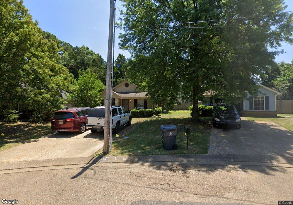
571 Shady Grove E Hernando, MS 38632
Estimated Value: $147,000 - $243,000
3
Beds
2
Baths
1,068
Sq Ft
$181/Sq Ft
Est. Value
About This Home
This home is located at 571 Shady Grove E, Hernando, MS 38632 and is currently estimated at $192,862, approximately $180 per square foot. 571 Shady Grove E is a home located in DeSoto County with nearby schools including Oak Grove Central Elementary School, Hernando Elementary School, and Hernando Hills Elementary.
Ownership History
Date
Name
Owned For
Owner Type
Purchase Details
Closed on
Nov 2, 2016
Sold by
Barnette Ralph D and Barnette Felicia Dawn
Bought by
E And K Investments Llc
Current Estimated Value
Purchase Details
Closed on
Oct 21, 2016
Sold by
Shirley Jennifer M
Bought by
Barnette Ralph D
Create a Home Valuation Report for This Property
The Home Valuation Report is an in-depth analysis detailing your home's value as well as a comparison with similar homes in the area
Home Values in the Area
Average Home Value in this Area
Purchase History
| Date | Buyer | Sale Price | Title Company |
|---|---|---|---|
| E And K Investments Llc | -- | Attorney | |
| Barnette Ralph D | -- | Attorney |
Source: Public Records
Tax History
| Year | Tax Paid | Tax Assessment Tax Assessment Total Assessment is a certain percentage of the fair market value that is determined by local assessors to be the total taxable value of land and additions on the property. | Land | Improvement |
|---|---|---|---|---|
| 2025 | $1,480 | $12,708 | $2,400 | $10,308 |
| 2024 | $1,320 | $9,517 | $2,400 | $7,117 |
| 2023 | $1,320 | $9,517 | $0 | $0 |
| 2022 | $1,320 | $9,517 | $2,400 | $7,117 |
| 2021 | $1,320 | $9,517 | $2,400 | $7,117 |
| 2020 | $1,241 | $8,948 | $0 | $0 |
| 2019 | $1,241 | $8,948 | $2,400 | $6,548 |
| 2017 | $1,212 | $14,984 | $8,692 | $6,292 |
| 2016 | $540 | $5,794 | $1,600 | $4,194 |
| 2015 | $774 | $9,988 | $5,794 | $4,194 |
| 2014 | $522 | $5,794 | $0 | $0 |
| 2013 | $522 | $5,794 | $0 | $0 |
Source: Public Records
Map
Nearby Homes
- 0 E Commerce St
- 1335 Creekside Blvd
- 665 Cedar Grove Cove
- 1705 Cedar Lake Cove
- 186 E South St
- 5 W Commerce St
- 2833 Mount Pleasant S
- 120 N Parkway St
- 4770 Mccracken Rd
- 136 N Parkway St
- 2035 Highway 51 S
- 1 E Oak Grove Rd
- 5188 Reserve Way
- 2197 Hyacinth Ln
- 3066 Meadows Way
- 1254 Creekside Ln
- 69 Lake Pointe Dr
- 1742 Keenlan Dr W
- 2953 Dove Cove
- 1106 Fawn Dr
- 567 Shady Grove E
- 575 Shady Grove E
- 567 Shady Grove E
- 561 Shady Grove E
- 579 Shady Grove E
- 553 Shady Grove E
- 556 Shady Grove E
- 547 Shady Grove E
- 562 Shady Grove E
- 365 Shady Lane Cove
- 362 Shady Lane Cove
- 363 Shady Lane Cove
- 364 Shady Lane Cove
- 360 Shady Lane Cove
- 361 Shady Lane Cove
- 358 Shady Lane Cove
- 359 Shady Lane Cove
- 356 Shady Lane Cove
- 357 Shady Lane Cove
- 355 Shady Lane Cove
Your Personal Tour Guide
Ask me questions while you tour the home.