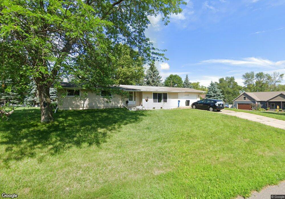
5749 Portland Ave Saint Paul, MN 55110
Estimated Value: $318,000 - $367,000
3
Beds
2
Baths
1,380
Sq Ft
$251/Sq Ft
Est. Value
About This Home
This home is located at 5749 Portland Ave, Saint Paul, MN 55110 and is currently estimated at $346,950, approximately $251 per square foot. 5749 Portland Ave is a home located in Ramsey County with nearby schools including Lincoln Elementary School, Central Middle School, and St. Jude of the Lake Catholic School.
Ownership History
Date
Name
Owned For
Owner Type
Purchase Details
Closed on
Jan 15, 2019
Sold by
Marnich Rolf J and Marnich Sherri L
Bought by
Brown Thomas M
Current Estimated Value
Home Financials for this Owner
Home Financials are based on the most recent Mortgage that was taken out on this home.
Original Mortgage
$175,655
Outstanding Balance
$154,749
Interest Rate
4.7%
Mortgage Type
New Conventional
Estimated Equity
$192,201
Purchase Details
Closed on
May 15, 2001
Sold by
Ruettimann Louis Michael and Ruettimann Ronnivan A
Bought by
Marnich Rolf J and Marnich Sherri L
Create a Home Valuation Report for This Property
The Home Valuation Report is an in-depth analysis detailing your home's value as well as a comparison with similar homes in the area
Home Values in the Area
Average Home Value in this Area
Purchase History
| Date | Buyer | Sale Price | Title Company |
|---|---|---|---|
| Brown Thomas M | $184,900 | Land Title Inc | |
| Marnich Rolf J | $172,025 | -- |
Source: Public Records
Mortgage History
| Date | Status | Borrower | Loan Amount |
|---|---|---|---|
| Open | Brown Thomas M | $175,655 |
Source: Public Records
Tax History Compared to Growth
Tax History
| Year | Tax Paid | Tax Assessment Tax Assessment Total Assessment is a certain percentage of the fair market value that is determined by local assessors to be the total taxable value of land and additions on the property. | Land | Improvement |
|---|---|---|---|---|
| 2025 | $3,456 | $312,700 | $118,600 | $194,100 |
| 2023 | $3,456 | $277,100 | $118,600 | $158,500 |
| 2022 | $2,814 | $271,700 | $118,600 | $153,100 |
| 2021 | $2,324 | $217,300 | $118,600 | $98,700 |
| 2020 | $3,384 | $189,800 | $118,600 | $71,200 |
| 2019 | $2,732 | $251,500 | $118,600 | $132,900 |
| 2018 | $2,694 | $221,000 | $118,600 | $102,400 |
| 2017 | $2,704 | $221,900 | $118,600 | $103,300 |
| 2016 | $2,962 | $0 | $0 | $0 |
| 2015 | $3,006 | $224,800 | $110,800 | $114,000 |
| 2014 | $2,658 | $0 | $0 | $0 |
Source: Public Records
Map
Nearby Homes
- 2656 Richard Dr
- 2614 Parkview Ct
- 5924 Polar Bear Ln
- 5553 Fenway Ct
- 2542 Buffalo St
- 5432 Williams Ave
- 5285 Northwest Ave
- 2574 1st St
- 5234 Grand Ave
- 2655 Stillwater St
- TBD Park Ave
- 12570 Foxhill Ave N
- 12562 Foxhill Ave N
- 5366 Eagle St
- 2615 Lake Ave
- 5200 Pathways Ave Unit 105
- 1 Bayhill Rd
- 12578 Fenway Ave N
- 42 Eldorado Cir
- 11 High Point Rd
- 2640 Bloom Rd
- 5740 Portland Ave
- 5725 Portland Ave
- 2653 Bloom Rd
- 2649 Bloom Rd
- 2632 Bloom Rd
- 5750 Portland Ave
- 5718 Portland Ave
- 5729 Morgan Trail
- 5749 Morgan Trail
- 5770 Portland Ave
- 2631 Bloom Rd
- 5781 Portland Ave
- 5719 Morgan Trail
- 5717 Portland Ave
- 2710 Silver Fox Rd
- 5709 Morgan Trail
- 5739 Morgan Trail
- 5712 Portland Ave
- 255X 255x Bloom-Road-