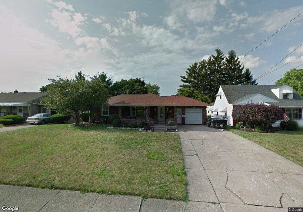
579 W Wilson St Struthers, OH 44471
Estimated Value: $138,000 - $157,918
3
Beds
1
Bath
1,016
Sq Ft
$149/Sq Ft
Est. Value
About This Home
This home is located at 579 W Wilson St, Struthers, OH 44471 and is currently estimated at $151,730, approximately $149 per square foot. 579 W Wilson St is a home located in Mahoning County with nearby schools including Mckamy Elementary School, Carrollton Elementary School, and Lovett Elementary School.
Ownership History
Date
Name
Owned For
Owner Type
Purchase Details
Closed on
Oct 8, 2004
Sold by
Dworak William and Dworak Cherlyn
Bought by
Coppola Kevin and Coppola Amy
Current Estimated Value
Home Financials for this Owner
Home Financials are based on the most recent Mortgage that was taken out on this home.
Original Mortgage
$80,000
Outstanding Balance
$35,861
Interest Rate
4.37%
Mortgage Type
New Conventional
Estimated Equity
$115,869
Purchase Details
Closed on
Jul 18, 1973
Bought by
Dworak William
Create a Home Valuation Report for This Property
The Home Valuation Report is an in-depth analysis detailing your home's value as well as a comparison with similar homes in the area
Home Values in the Area
Average Home Value in this Area
Purchase History
| Date | Buyer | Sale Price | Title Company |
|---|---|---|---|
| Coppola Kevin | $100,000 | -- | |
| Dworak William | -- | -- |
Source: Public Records
Mortgage History
| Date | Status | Borrower | Loan Amount |
|---|---|---|---|
| Open | Coppola Kevin | $80,000 | |
| Closed | Coppola Kevin | $20,000 |
Source: Public Records
Tax History Compared to Growth
Tax History
| Year | Tax Paid | Tax Assessment Tax Assessment Total Assessment is a certain percentage of the fair market value that is determined by local assessors to be the total taxable value of land and additions on the property. | Land | Improvement |
|---|---|---|---|---|
| 2024 | $1,714 | $41,140 | $4,820 | $36,320 |
| 2023 | $1,685 | $41,140 | $4,820 | $36,320 |
| 2022 | $1,476 | $27,270 | $4,530 | $22,740 |
| 2021 | $1,463 | $27,270 | $4,530 | $22,740 |
| 2020 | $1,469 | $27,270 | $4,530 | $22,740 |
| 2019 | $1,407 | $23,710 | $3,940 | $19,770 |
| 2018 | $1,342 | $23,710 | $3,940 | $19,770 |
| 2017 | $1,380 | $23,710 | $3,940 | $19,770 |
| 2016 | $1,420 | $25,730 | $4,600 | $21,130 |
| 2015 | $1,387 | $25,730 | $4,600 | $21,130 |
| 2014 | $1,392 | $25,730 | $4,600 | $21,130 |
| 2013 | $1,294 | $25,730 | $4,600 | $21,130 |
Source: Public Records
Map
Nearby Homes
- 550 Brandon Ave
- 2021 Country Club Ave
- 491 Spring St
- 418 W Wilson St
- 576 W Harvey St
- 608 Maplewood Ave
- 525 W Omar St
- 478 W Harvey St
- 1913 Country Club Ave
- 1933 Brandon Ave
- 795 5th St
- 2002 Bancroft Ave
- 2001 Brownlee Ave
- 4528 Sheridan Rd
- 2089 Shetland Ln
- 506 8th St
- 1645 Chattanooga Ave
- 1919 Wingate Rd
- 281 Sexton St
- 2296 Knollwood Ave