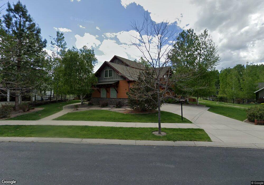
58 W Fieldview Cir Bozeman, MT 59715
South Bozeman NeighborhoodEstimated Value: $1,365,000 - $1,605,000
4
Beds
3
Baths
3,335
Sq Ft
$440/Sq Ft
Est. Value
About This Home
This home is located at 58 W Fieldview Cir, Bozeman, MT 59715 and is currently estimated at $1,468,000, approximately $440 per square foot. 58 W Fieldview Cir is a home located in Gallatin County with nearby schools including Morning Star School, Sacajawea Middle School, and Bozeman High School.
Ownership History
Date
Name
Owned For
Owner Type
Purchase Details
Closed on
Mar 19, 2007
Sold by
Staples Dennis and Staples Marnie
Bought by
Mccarthy Daniel A
Current Estimated Value
Home Financials for this Owner
Home Financials are based on the most recent Mortgage that was taken out on this home.
Original Mortgage
$304,000
Outstanding Balance
$184,309
Interest Rate
6.29%
Mortgage Type
Purchase Money Mortgage
Estimated Equity
$1,283,691
Purchase Details
Closed on
Jan 6, 2005
Sold by
Heirloom Homes Inc
Bought by
Staples Dennis and Staples Marnie
Home Financials for this Owner
Home Financials are based on the most recent Mortgage that was taken out on this home.
Original Mortgage
$333,700
Interest Rate
5.7%
Mortgage Type
Purchase Money Mortgage
Create a Home Valuation Report for This Property
The Home Valuation Report is an in-depth analysis detailing your home's value as well as a comparison with similar homes in the area
Home Values in the Area
Average Home Value in this Area
Purchase History
| Date | Buyer | Sale Price | Title Company |
|---|---|---|---|
| Mccarthy Daniel A | -- | American Land Title Company | |
| Staples Dennis | -- | American Land Title Company |
Source: Public Records
Mortgage History
| Date | Status | Borrower | Loan Amount |
|---|---|---|---|
| Open | Mccarthy Daniel A | $304,000 | |
| Previous Owner | Staples Dennis | $333,700 |
Source: Public Records
Tax History Compared to Growth
Tax History
| Year | Tax Paid | Tax Assessment Tax Assessment Total Assessment is a certain percentage of the fair market value that is determined by local assessors to be the total taxable value of land and additions on the property. | Land | Improvement |
|---|---|---|---|---|
| 2025 | $7,678 | $1,497,000 | $0 | $0 |
| 2024 | $9,080 | $1,364,000 | $0 | $0 |
| 2023 | $8,778 | $1,364,000 | $0 | $0 |
| 2022 | $7,055 | $920,100 | $0 | $0 |
| 2021 | $7,785 | $920,100 | $0 | $0 |
| 2020 | $6,282 | $735,800 | $0 | $0 |
| 2019 | $6,425 | $735,800 | $0 | $0 |
| 2018 | $6,452 | $684,800 | $0 | $0 |
| 2017 | $6,032 | $684,800 | $0 | $0 |
| 2016 | $5,385 | $571,200 | $0 | $0 |
| 2015 | $5,391 | $571,200 | $0 | $0 |
| 2014 | $5,869 | $366,071 | $0 | $0 |
Source: Public Records
Map
Nearby Homes
- 3726 Bungalow Ln
- Lot 129 Graf St
- 4235 Graf St
- 3300 E Graf St Unit 45
- 1301 Cambridge Dr
- 1605 Cambridge Dr
- 1517 Cambridge Dr
- 1525 Cambridge Dr
- 1617 Cambridge Dr
- 1621 Cambridge Dr
- 1609 Cambridge Dr
- 1613 Cambridge Dr
- 3118 Gardenbrook Ln
- 4510 Morning Sun Dr
- 2516 Spring Creek Dr
- 1115 Cambridge Dr
- 5041 S 3rd Ave
- 1306 Cambridge Dr
- 1310 Cambridge Dr
- 41 Hitching Post Rd Unit B
- 60 W Fieldview Cir
- 52 W Fieldview Cir
- 174 Arcadia Ln
- 64 W Fieldview Cir
- 46 W Fieldview Cir
- 191 Arcadia Ln
- 72 W Fieldview Cir
- 169 Arcadia Ln
- 40 W Fieldview Cir
- TBD Arcadia Ln
- 136 Arcadia Ln
- 3318 Sundance Dr
- 76 W Fieldview Cir
- 147 Arcadia Ln
- 30 W Fieldview Cir
- 77 W Fieldview Creek
- 83 W Fieldview Cir
- 121 Arcadia Ln
- 35 W Fieldview Cir
- 35 W Fieldview Cir