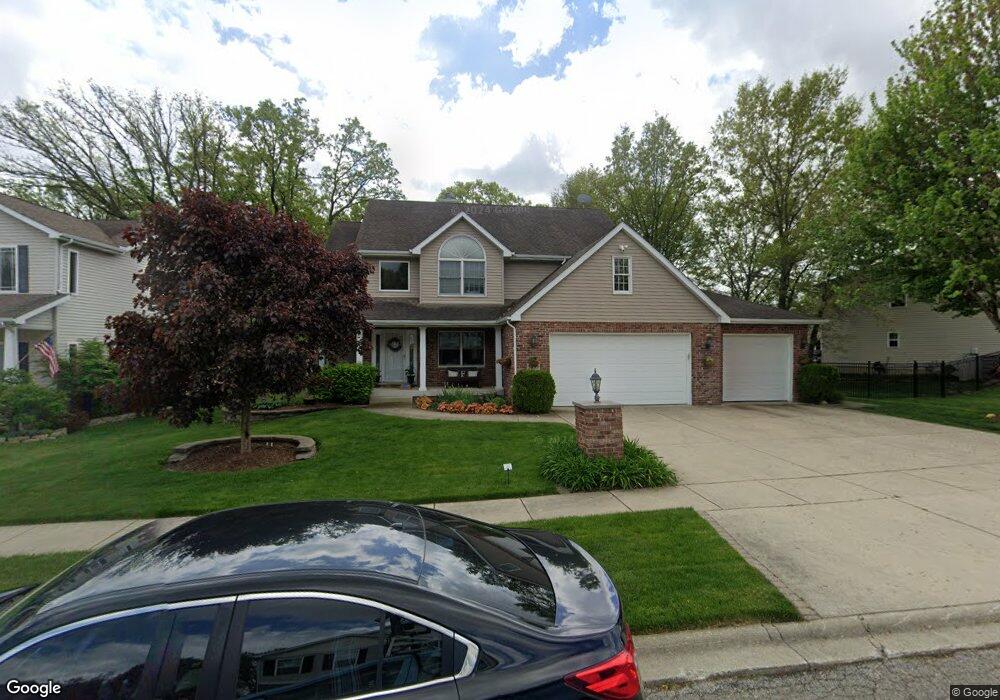
5839 High Grove Ct Lowell, IN 46356
Cedar Creek NeighborhoodEstimated Value: $491,000 - $608,000
3
Beds
4
Baths
3,046
Sq Ft
$180/Sq Ft
Est. Value
About This Home
This home is located at 5839 High Grove Ct, Lowell, IN 46356 and is currently estimated at $546,970, approximately $179 per square foot. 5839 High Grove Ct is a home located in Lake County with nearby schools including Lowell Middle School and Lowell Senior High School.
Ownership History
Date
Name
Owned For
Owner Type
Purchase Details
Closed on
Dec 8, 2005
Sold by
Eggert Builders Inc
Bought by
Farmer Donald R and Farmer Anna M
Current Estimated Value
Home Financials for this Owner
Home Financials are based on the most recent Mortgage that was taken out on this home.
Original Mortgage
$292,248
Outstanding Balance
$164,194
Interest Rate
6.36%
Mortgage Type
Fannie Mae Freddie Mac
Estimated Equity
$382,776
Purchase Details
Closed on
Jun 3, 2005
Sold by
Demotte State Bank
Bought by
Eggert Builders Inc
Create a Home Valuation Report for This Property
The Home Valuation Report is an in-depth analysis detailing your home's value as well as a comparison with similar homes in the area
Home Values in the Area
Average Home Value in this Area
Purchase History
| Date | Buyer | Sale Price | Title Company |
|---|---|---|---|
| Farmer Donald R | -- | Chicago Title Insurance Comp | |
| Eggert Builders Inc | -- | Community Title Company |
Source: Public Records
Mortgage History
| Date | Status | Borrower | Loan Amount |
|---|---|---|---|
| Open | Farmer Donald R | $292,248 |
Source: Public Records
Tax History Compared to Growth
Tax History
| Year | Tax Paid | Tax Assessment Tax Assessment Total Assessment is a certain percentage of the fair market value that is determined by local assessors to be the total taxable value of land and additions on the property. | Land | Improvement |
|---|---|---|---|---|
| 2024 | $12,130 | $456,700 | $49,900 | $406,800 |
| 2023 | $4,928 | $457,600 | $49,900 | $407,700 |
| 2022 | $4,591 | $428,200 | $36,300 | $391,900 |
| 2021 | $4,325 | $400,200 | $36,300 | $363,900 |
| 2020 | $4,226 | $389,300 | $36,300 | $353,000 |
| 2019 | $4,233 | $378,300 | $36,300 | $342,000 |
| 2018 | $4,868 | $369,200 | $36,300 | $332,900 |
| 2017 | $4,743 | $343,000 | $36,300 | $306,700 |
| 2016 | $4,807 | $353,400 | $41,900 | $311,500 |
| 2014 | $5,041 | $356,900 | $41,900 | $315,000 |
| 2013 | $5,234 | $353,400 | $41,900 | $311,500 |
Source: Public Records
Map
Nearby Homes
- 5929 W 172nd Ave
- 8689 Graystone Dr
- 8621 Graystone Dr
- 8558 Graystone Dr
- 8602 Graystone Dr
- 8587 Graystone Dr
- 8569 Graystone Dr
- 17229 Brookwood Dr
- 16830 Mount St
- 7003 W Appr 173rd Place
- 7006 W 173rd Ln
- 17583 Marion Dr
- 6239 Sarah Ln Unit 3
- 4380 166th Ln
- 18425 Alexander Ave
- 18415 Alexander Ave
- 4398 Willard Ln
- 5104 Southview Dr
- 4906 Southview Dr
- 17603 Mount St
- 5825 High Grove Ct
- 5843 High Grove Ct
- 0-Lot 77 High Grove Ct
- 0-Lot 78 High Grove Ct
- 17147 High Grove Ct
- Lot 81 High Grove Ct
- Lot 74 High Grove Ct
- Lot 71 High Grove Ct
- Lot 69 High Grove Ct
- Lot 72 High Grove Ct
- Lot 76 High Grove Ct
- Lot 73 High Grove Ct
- LOT 67 High Grove Ct
- LOT 70 High Grove Ct
- LOT 65 High Grove Ct
- LOT 66 High Grove Ct
- Lot 78 High Grove Ct
- 5856-LOT 67 High Grove Ct
- 5843-Lot 81 High Grove Ct
- 5840-Lot 69 High Grove Ct