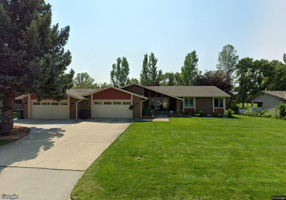
5840 Sam Snead Trail Billings, MT 59106
West Shiloh NeighborhoodEstimated Value: $645,421 - $740,000
5
Beds
4
Baths
3,648
Sq Ft
$188/Sq Ft
Est. Value
About This Home
This home is located at 5840 Sam Snead Trail, Billings, MT 59106 and is currently estimated at $687,355, approximately $188 per square foot. 5840 Sam Snead Trail is a home located in Yellowstone County with nearby schools including Arrowhead School, Ben Steele Middle School, and Billings West High School.
Ownership History
Date
Name
Owned For
Owner Type
Purchase Details
Closed on
Jul 15, 2024
Sold by
Olschlager Adam M
Bought by
Shovic Henry F and Coleman Rhoda J
Current Estimated Value
Purchase Details
Closed on
Feb 15, 2022
Sold by
Sarah Olschlager
Bought by
Olschlager Adam M
Purchase Details
Closed on
Jul 14, 2015
Sold by
Hellinger Robert and Hellinger Larena Mariko
Bought by
Costello Patrick J and Swenson Jill M
Home Financials for this Owner
Home Financials are based on the most recent Mortgage that was taken out on this home.
Original Mortgage
$150,000
Interest Rate
3.98%
Mortgage Type
New Conventional
Create a Home Valuation Report for This Property
The Home Valuation Report is an in-depth analysis detailing your home's value as well as a comparison with similar homes in the area
Home Values in the Area
Average Home Value in this Area
Purchase History
| Date | Buyer | Sale Price | Title Company |
|---|---|---|---|
| Shovic Henry F | -- | Stewart Title | |
| Olschlager Adam M | -- | None Listed On Document | |
| Costello Patrick J | -- | Stewart Title |
Source: Public Records
Mortgage History
| Date | Status | Borrower | Loan Amount |
|---|---|---|---|
| Previous Owner | Costello Patrick J | $150,000 |
Source: Public Records
Tax History Compared to Growth
Tax History
| Year | Tax Paid | Tax Assessment Tax Assessment Total Assessment is a certain percentage of the fair market value that is determined by local assessors to be the total taxable value of land and additions on the property. | Land | Improvement |
|---|---|---|---|---|
| 2025 | $5,065 | $630,700 | $93,020 | $537,680 |
| 2024 | $5,065 | $508,800 | $87,278 | $421,522 |
| 2023 | $5,041 | $508,800 | $87,278 | $421,522 |
| 2022 | $4,290 | $454,400 | $0 | $0 |
| 2021 | $4,799 | $454,400 | $0 | $0 |
| 2020 | $4,641 | $420,000 | $0 | $0 |
| 2019 | $4,431 | $420,000 | $0 | $0 |
| 2018 | $4,309 | $400,500 | $0 | $0 |
| 2017 | $3,707 | $400,500 | $0 | $0 |
| 2016 | $3,894 | $375,500 | $0 | $0 |
| 2015 | $4,225 | $389,200 | $0 | $0 |
| 2014 | $3,771 | $181,525 | $0 | $0 |
Source: Public Records
Map
Nearby Homes
- 5810 Sam Snead Trail
- 5625 Walter Hagen Dr
- 3230 Ben Hogan Ln
- 6116 Sam Snead Trail
- 3671 Spalding Ave
- 6020 Hazelwood Dr
- 5432 Billy Casper Dr
- 5522 Bobby Jones Blvd
- 3035 Arnold Palmer Dr
- Lot 22 Aston Bay Cr
- Lot 23 Aston Bay Cr
- Lot 21 Aston Bay Cr
- Lot 24 Aston Bay Cr
- Lot 13 Glynn Abby Trail
- Lot 14 Glynn Abby Trail
- 3485 Stone Mountain Cir
- 3980 Trailwood Dr
- 2659 Arnold Palmer Dr
- 5650 Canyonwoods Dr
- 3127 Falcon Cir
- 5832 Sam Snead Trail
- 5848 Sam Snead Trail
- 5841 Sam Snead Trail
- 5833 Sam Snead Trail
- 5849 Sam Snead Trail
- 5820 Sam Snead Trail
- 5856 Sam Snead Trail
- 5823 Sam Snead Trail
- 5857 Sam Snead Trail
- 5813 Sam Snead Trail
- 5864 Sam Snead Trail
- 5805 Sam Snead Trail
- 5800 Sam Snead Trail
- 5905 Sam Snead Trail
- 5906 Sam Snead Trail
- 0 Sam Snead Trail
- 00 Sam Snead Trail
- 5915 Sam Snead Trail
- 5916 Sam Snead Trail
- 5925 Sam Snead Trail