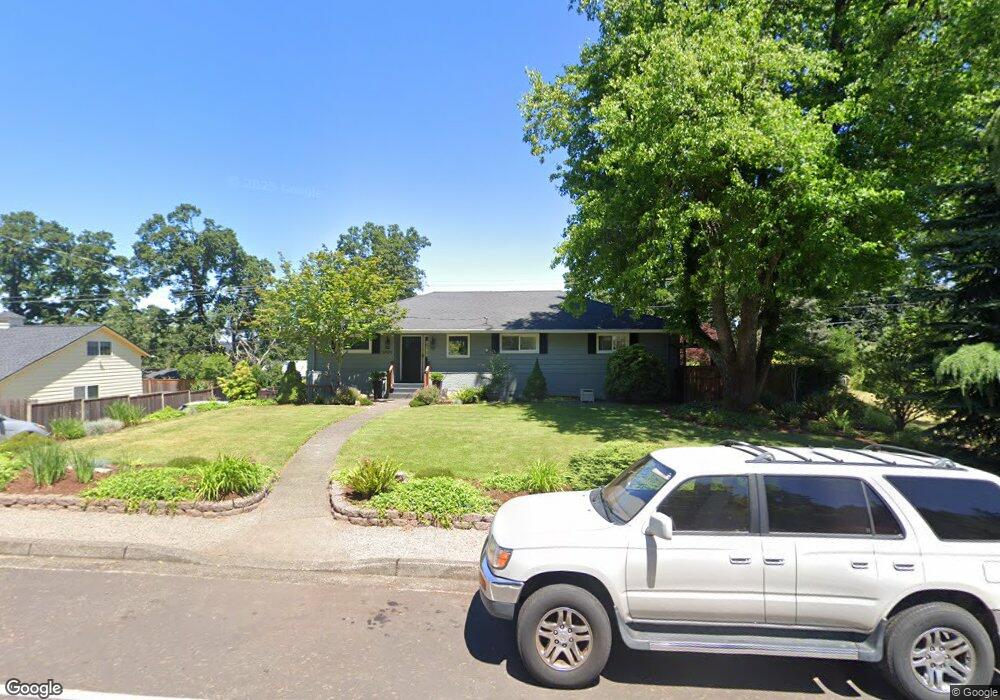
5899 W A St West Linn, OR 97068
Bolton NeighborhoodEstimated Value: $779,891 - $849,000
4
Beds
2
Baths
3,333
Sq Ft
$248/Sq Ft
Est. Value
About This Home
This home is located at 5899 W A St, West Linn, OR 97068 and is currently estimated at $826,473, approximately $247 per square foot. 5899 W A St is a home located in Clackamas County with nearby schools including Bolton Primary School, West Linn High School, and Clackamas Academy of Industrial Sciences (CAIS).
Ownership History
Date
Name
Owned For
Owner Type
Purchase Details
Closed on
Sep 20, 2021
Sold by
Carver Donald G and Carver Connie L
Bought by
Carver Family Trust
Current Estimated Value
Purchase Details
Closed on
Mar 6, 1996
Sold by
Stimac David J and Stimac Paula A
Bought by
Carver Donald G and Carver Connie L
Home Financials for this Owner
Home Financials are based on the most recent Mortgage that was taken out on this home.
Original Mortgage
$145,399
Interest Rate
6.5%
Mortgage Type
FHA
Create a Home Valuation Report for This Property
The Home Valuation Report is an in-depth analysis detailing your home's value as well as a comparison with similar homes in the area
Home Values in the Area
Average Home Value in this Area
Purchase History
| Date | Buyer | Sale Price | Title Company |
|---|---|---|---|
| Carver Family Trust | -- | None Listed On Document | |
| Carver Donald G | $158,400 | Fidelity National Title |
Source: Public Records
Mortgage History
| Date | Status | Borrower | Loan Amount |
|---|---|---|---|
| Previous Owner | Carver Donald G | $145,399 |
Source: Public Records
Tax History Compared to Growth
Tax History
| Year | Tax Paid | Tax Assessment Tax Assessment Total Assessment is a certain percentage of the fair market value that is determined by local assessors to be the total taxable value of land and additions on the property. | Land | Improvement |
|---|---|---|---|---|
| 2025 | $5,974 | $310,009 | -- | -- |
| 2024 | $5,751 | $300,980 | -- | -- |
| 2023 | $5,751 | $292,214 | $0 | $0 |
| 2022 | $5,428 | $283,703 | $0 | $0 |
| 2021 | $5,153 | $275,440 | $0 | $0 |
| 2020 | $5,188 | $267,418 | $0 | $0 |
| 2019 | $4,947 | $259,630 | $0 | $0 |
| 2018 | $4,726 | $252,068 | $0 | $0 |
| 2017 | $4,543 | $244,726 | $0 | $0 |
| 2016 | $4,425 | $237,598 | $0 | $0 |
| 2015 | $4,299 | $230,678 | $0 | $0 |
| 2014 | $4,139 | $223,959 | $0 | $0 |
Source: Public Records
Map
Nearby Homes
- 5910 W A St
- 1954 Buck St
- 6345 Caufield St
- 5128 Firwood Dr
- 6403 Tompkins Ct
- 5219 Summit St
- 5062 Prospect St
- 20930 Fawn Ct Unit 26
- 5687 River St
- 4973 Summit St
- 22691 Oregon City Loop
- 2764 Ridge Ln
- 2488 Tulane St
- 5390 Grove St
- 22881 Oregon City Loop
- 4794 Coho Ln
- 2530 Cambridge St
- 4711 Alder St
- 1470 Rosemont Rd
- 4050 Serango Ct
- 5905 W A St
- 5891 W A St
- 5901 W A St
- 5903 W A St
- 21645 Mount Hood Terrace
- 21635 Mount Hood Terrace
- 21635 Mount Hood Te
- 5909 W A St
- 21625 Willamette Dr
- 5888 W A St Unit 1
- 5888 W A St
- 21625 Mount Hood Terrace
- 5860 W A St
- 5845 W A St
- 21615 Mount Hood Terrace
- 5835 Broadway St
- 21635 Willamette Dr
- 5955 W A St
- 21605 Willamette Dr
- 5870 W A St