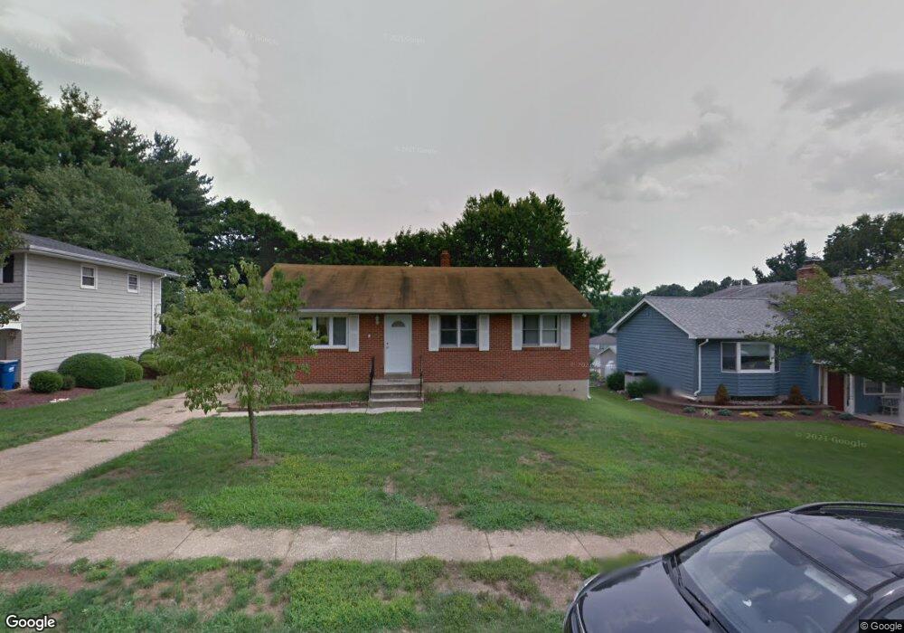
59 Vansant Rd Newark, DE 19711
Estimated Value: $286,000 - $383,000
3
Beds
1
Bath
1,176
Sq Ft
$295/Sq Ft
Est. Value
About This Home
This home is located at 59 Vansant Rd, Newark, DE 19711 and is currently estimated at $346,665, approximately $294 per square foot. 59 Vansant Rd is a home located in New Castle County with nearby schools including Wilson (Etta J.) Elementary School, Shue-Medill Middle School, and Newark High School.
Ownership History
Date
Name
Owned For
Owner Type
Purchase Details
Closed on
Apr 1, 2013
Sold by
Callahan Thomas and Callahan Elizabeth
Bought by
Callahan Thomas W
Current Estimated Value
Purchase Details
Closed on
Mar 19, 2012
Sold by
Callahan Thomas and Callahan Elizabeth
Bought by
Callahan Thomas and Callahan Elizabeth
Purchase Details
Closed on
Oct 20, 2011
Sold by
Lindsay Alise C and Gmac Mortgage Llc
Bought by
Federal Home Loan Mortgage Corporation
Purchase Details
Closed on
Dec 28, 2010
Sold by
Lindsay Alise C
Bought by
Federal Home Loan Mortgage Corp
Purchase Details
Closed on
Oct 22, 2002
Sold by
Lindsay Donald B
Bought by
Lindsay Alise C
Create a Home Valuation Report for This Property
The Home Valuation Report is an in-depth analysis detailing your home's value as well as a comparison with similar homes in the area
Home Values in the Area
Average Home Value in this Area
Purchase History
| Date | Buyer | Sale Price | Title Company |
|---|---|---|---|
| Callahan Thomas W | -- | None Available | |
| Callahan Thomas | -- | None Available | |
| Federal Home Loan Mortgage Corporation | $174,319 | None Available | |
| Federal Home Loan Mortgage Corp | $174,319 | None Available | |
| Lindsay Alise C | -- | -- |
Source: Public Records
Tax History Compared to Growth
Tax History
| Year | Tax Paid | Tax Assessment Tax Assessment Total Assessment is a certain percentage of the fair market value that is determined by local assessors to be the total taxable value of land and additions on the property. | Land | Improvement |
|---|---|---|---|---|
| 2024 | $2,436 | $57,200 | $13,900 | $43,300 |
| 2023 | $2,369 | $57,200 | $13,900 | $43,300 |
| 2022 | $2,363 | $57,200 | $13,900 | $43,300 |
| 2021 | $2,253 | $57,200 | $13,900 | $43,300 |
| 2020 | $0 | $57,200 | $13,900 | $43,300 |
| 2019 | $2,300 | $57,200 | $13,900 | $43,300 |
| 2018 | $1,939 | $57,200 | $13,900 | $43,300 |
| 2017 | $1,870 | $57,200 | $13,900 | $43,300 |
| 2016 | $1,866 | $57,200 | $13,900 | $43,300 |
| 2015 | $1,700 | $57,200 | $13,900 | $43,300 |
| 2014 | $1,699 | $57,200 | $13,900 | $43,300 |
Source: Public Records
Map
Nearby Homes
- 423 Polly Drummond Hill Rd
- 6 Sheldon Dr
- 3206 Champions Dr
- 4701 Birch Cir
- 5537 Doral Dr
- 148 Drummond Farms Ln
- 3407 Birch Cir Unit 7
- 201 Thomas Ln S
- 610 Benham Ct
- 5003 Birch Cir Unit 152
- 3262 Champions Dr
- 4855 Plum Run Ct
- 5403 Diana Dr Unit 188
- 473 Polly Drummond Hill Rd
- 5413 Pinehurst Dr
- 3240 Brookline Rd
- 5309 Pinehurst Dr
- 4815 Hogan Dr
- 4811 Hogan Dr Unit 3
- 4809 Hogan Dr Unit 4