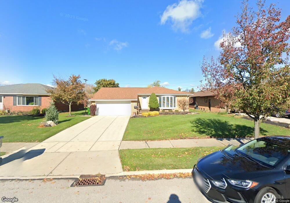
5921 Mayflower Ave Cleveland, OH 44124
Estimated Value: $270,000 - $300,000
3
Beds
2
Baths
1,544
Sq Ft
$184/Sq Ft
Est. Value
About This Home
This home is located at 5921 Mayflower Ave, Cleveland, OH 44124 and is currently estimated at $284,327, approximately $184 per square foot. 5921 Mayflower Ave is a home located in Cuyahoga County with nearby schools including Mayfield High School, Corpus Christi Academy, and Hawken Lower-Middle School.
Ownership History
Date
Name
Owned For
Owner Type
Purchase Details
Closed on
Aug 23, 2022
Sold by
Zummo Frank J and Leibin Lori Zummo
Bought by
Ketzak Nancy J
Current Estimated Value
Purchase Details
Closed on
Apr 26, 2004
Sold by
Zummo Joseph F
Bought by
Zummo Frank J and Zummo Joseph F
Purchase Details
Closed on
Jan 18, 2000
Sold by
Estate Of Anna J Ferrara
Bought by
Zummo Joseph F and Colletti Theresa
Purchase Details
Closed on
Mar 30, 1993
Sold by
Zummo Frank A and Colletti F
Bought by
Colletti Frances
Purchase Details
Closed on
Jan 1, 1975
Bought by
Zummo Frank A and Zummo Colletti F
Create a Home Valuation Report for This Property
The Home Valuation Report is an in-depth analysis detailing your home's value as well as a comparison with similar homes in the area
Home Values in the Area
Average Home Value in this Area
Purchase History
| Date | Buyer | Sale Price | Title Company |
|---|---|---|---|
| Ketzak Nancy J | -- | Fast Tract Title Services | |
| Zummo Frank J | -- | -- | |
| Zummo Joseph F | -- | -- | |
| Colletti Frances | -- | -- | |
| Zummo Frank A | -- | -- |
Source: Public Records
Tax History Compared to Growth
Tax History
| Year | Tax Paid | Tax Assessment Tax Assessment Total Assessment is a certain percentage of the fair market value that is determined by local assessors to be the total taxable value of land and additions on the property. | Land | Improvement |
|---|---|---|---|---|
| 2024 | $5,666 | $96,285 | $15,120 | $81,165 |
| 2023 | $4,107 | $66,930 | $13,760 | $53,170 |
| 2022 | $4,286 | $66,920 | $13,760 | $53,170 |
| 2021 | $4,242 | $66,920 | $13,760 | $53,170 |
| 2020 | $3,862 | $57,190 | $11,760 | $45,430 |
| 2019 | $3,743 | $163,400 | $33,600 | $129,800 |
| 2018 | $3,722 | $57,190 | $11,760 | $45,430 |
| 2017 | $3,600 | $52,510 | $9,840 | $42,670 |
| 2016 | $3,573 | $52,510 | $9,840 | $42,670 |
| 2015 | $3,232 | $52,510 | $9,840 | $42,670 |
| 2014 | $3,232 | $51,490 | $9,630 | $41,860 |
Source: Public Records
Map
Nearby Homes
- 5931 Mayberry Ave
- 1574 Hawthorne Dr
- 1590 Longwood Dr
- 1575 Lander Rd
- 1430 Belrose Rd
- 1572 Crestwood Rd
- 1363 Ranchland Dr
- 1737 Mayfair Blvd
- 1763 Temple Ave
- 1379 Lander Rd
- 5688 Shawnee Dr
- 1337 Elmwood Rd
- 1328 Elmwood Rd
- 1391 Iroquois Ave
- 5960 Cantwell Dr
- 6132 Westerham Rd
- 1839 Caronia Dr
- 1775 Brainard Rd
- 5831 Alberta Dr
- 1542 Woodhurst Ave
- 5917 Mayflower Ave
- 5925 Mayflower Ave
- 5918 Mayberry Ave
- 5922 Mayberry Ave
- 5913 Mayflower Ave
- 5929 Mayflower Ave
- 5914 Mayberry Ave
- 5926 Mayberry Ave
- 5922 Mayflower Ave
- 5930 Mayberry Ave
- 5926 Mayflower Ave
- 5933 Mayflower Ave
- 5910 Mayflower Ave
- 5930 Mayflower Ave
- 1617 Mallard Dr
- 1621 Mallard Dr
- 1613 Mallard Dr
- 1629 Mallard Dr
- 5934 Mayberry Ave
- 1609 Mallard Dr