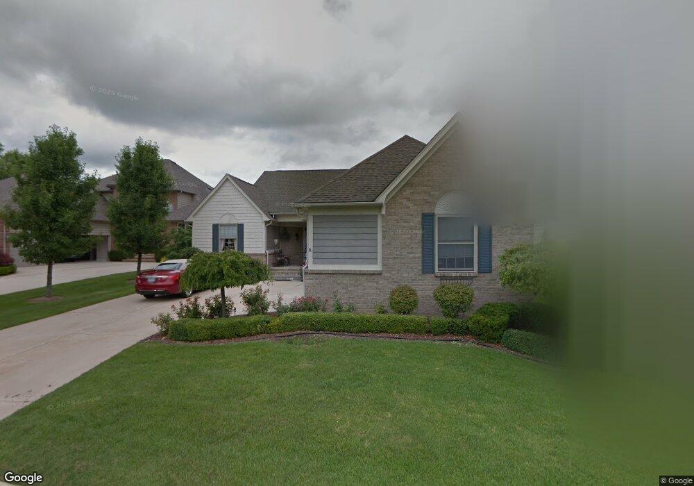
59768 Glacier Ridge N Washington, MI 48094
Estimated Value: $453,000 - $630,000
3
Beds
3
Baths
1,922
Sq Ft
$276/Sq Ft
Est. Value
About This Home
This home is located at 59768 Glacier Ridge N, Washington, MI 48094 and is currently estimated at $530,632, approximately $276 per square foot. 59768 Glacier Ridge N is a home located in Macomb County with nearby schools including Indian Hills Elementary School and Cross Of Glory Lutheran School.
Ownership History
Date
Name
Owned For
Owner Type
Purchase Details
Closed on
Jun 18, 2025
Sold by
Bird Wayne M and Bird Patricia S
Bought by
Bird Wayne M and Bird Patricia S
Current Estimated Value
Purchase Details
Closed on
Jun 5, 2017
Sold by
Divergilio Marguerite and Marguerite Divergilio Tru St
Bought by
Bird Patricia S and Bird Wayne M
Home Financials for this Owner
Home Financials are based on the most recent Mortgage that was taken out on this home.
Interest Rate
3.94%
Purchase Details
Closed on
Nov 18, 2015
Sold by
Gill Gary D and Gill Sandie A
Bought by
The Marguerite Divergilio Trust
Purchase Details
Closed on
Oct 29, 1999
Sold by
Glacier Development Comp
Bought by
Beattie John R
Create a Home Valuation Report for This Property
The Home Valuation Report is an in-depth analysis detailing your home's value as well as a comparison with similar homes in the area
Home Values in the Area
Average Home Value in this Area
Purchase History
| Date | Buyer | Sale Price | Title Company |
|---|---|---|---|
| Bird Wayne M | -- | None Listed On Document | |
| Bird Patricia S | $345,000 | -- | |
| The Marguerite Divergilio Trust | $333,000 | Visionary Title Agency Llc | |
| Beattie John R | $50,000 | -- |
Source: Public Records
Mortgage History
| Date | Status | Borrower | Loan Amount |
|---|---|---|---|
| Previous Owner | Bird Patricia S | -- |
Source: Public Records
Tax History Compared to Growth
Tax History
| Year | Tax Paid | Tax Assessment Tax Assessment Total Assessment is a certain percentage of the fair market value that is determined by local assessors to be the total taxable value of land and additions on the property. | Land | Improvement |
|---|---|---|---|---|
| 2025 | $6,268 | $217,700 | $0 | $0 |
| 2024 | $4,234 | $219,000 | $0 | $0 |
| 2023 | $4,081 | $231,100 | $0 | $0 |
| 2022 | $5,671 | $204,600 | $0 | $0 |
| 2021 | $5,547 | $198,000 | $0 | $0 |
| 2020 | $3,779 | $178,500 | $0 | $0 |
| 2019 | $5,090 | $170,000 | $0 | $0 |
| 2018 | $5,072 | $168,800 | $0 | $0 |
| 2017 | $4,609 | $154,400 | $47,500 | $106,900 |
| 2016 | $4,617 | $154,400 | $0 | $0 |
| 2015 | -- | $131,200 | $0 | $0 |
| 2013 | $2,906 | $110,100 | $20,000 | $90,100 |
| 2012 | $2,906 | $99,100 | $0 | $0 |
Source: Public Records
Map
Nearby Homes
- 59601 Van Dyke Rd
- 7966 Firestone Ln Unit 44
- 00 28 Mile
- schoenherr SE Rd SE
- 29 Mile
- 6933 Boulder Pointe Dr Unit 59
- 6109 Whispering Oak Dr
- 00 Oakridge Dr
- 60975 Stonecrest Dr
- 7721 Marble Ct
- 6797 Boulder Pointe Dr Unit 25
- 6725 Boulder Pointe Dr Unit 7
- 6713 Boulder Pointe Dr Unit 4
- 60023 Trailwood St
- 8400 27 Mile Rd Unit Lot 2
- 8400 27 Mile Rd Unit Lot 1
- 8699 Pioneer St
- 57297 Van Dyke Ave
- 60942 Campground Rd
- 58152 Carbine
- 59768 Glacier Ridge N Unit 64
- 59756 Glacier Ridge N
- 59779 Glacier Ridge N
- 59771 Glacier Ridge N
- 59771 Glacier Ridge N Unit N
- 59759 Glacier Ridge N
- 59780 Glacier Ridge N Unit 63
- 0 Glacier Club Dr
- 59732 Glacier Ridge S
- 59783 Glacier Ridge N Unit 57
- 7883 Glacier Club Dr
- 7883 Glacier Club Dr Unit 19
- 59723 Glacier Ridge S Unit 23
- 59792 Glacier Ridge N Unit 62
- 7885 Glacier Club Dr Unit 20
- 7885 Glacier Club Dr
- 59800 Glacier Ridge N
- 59795 Glacier Ridge N Unit 58
- 59803 Glacier Ridge N Unit 60
- 7887 Glacier Club Dr