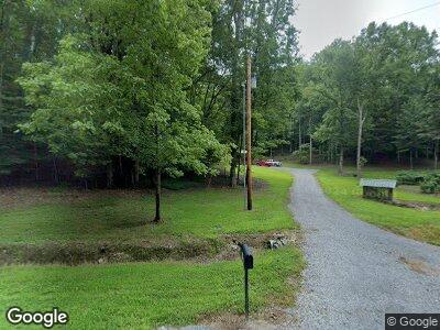
599 Dry Prong Rd Mulberry, TN 37359
Estimated Value: $229,494 - $288,000
--
Bed
--
Bath
960
Sq Ft
$265/Sq Ft
Est. Value
About This Home
This home is located at 599 Dry Prong Rd, Mulberry, TN 37359 and is currently estimated at $254,165, approximately $264 per square foot. 599 Dry Prong Rd is a home with nearby schools including Lynchburg Elementary School and Moore County High School.
Ownership History
Date
Name
Owned For
Owner Type
Purchase Details
Closed on
Oct 24, 2019
Sold by
Bohannon Brian C and Bohannon Beth A
Bought by
Caldwell Darlene Kay
Current Estimated Value
Purchase Details
Closed on
May 10, 2005
Sold by
Not Provided
Bought by
Bohannon Brian C
Purchase Details
Closed on
Mar 22, 2005
Sold by
Not Provided
Bought by
Bohannon Brian C
Purchase Details
Closed on
Jul 11, 2000
Bought by
Eslick Joe L
Purchase Details
Closed on
Jun 26, 1993
Bought by
Mcgee David R and Mcgee Nancy J
Create a Home Valuation Report for This Property
The Home Valuation Report is an in-depth analysis detailing your home's value as well as a comparison with similar homes in the area
Home Values in the Area
Average Home Value in this Area
Purchase History
| Date | Buyer | Sale Price | Title Company |
|---|---|---|---|
| Caldwell Darlene Kay | $55,000 | None Available | |
| Bohannon Brian C | $48,500 | -- | |
| Bohannon Brian C | $35,000 | -- | |
| Eslick Joe L | $89,900 | -- | |
| Mcgee David R | $30,000 | -- |
Source: Public Records
Tax History Compared to Growth
Tax History
| Year | Tax Paid | Tax Assessment Tax Assessment Total Assessment is a certain percentage of the fair market value that is determined by local assessors to be the total taxable value of land and additions on the property. | Land | Improvement |
|---|---|---|---|---|
| 2024 | $817 | $52,250 | $10,650 | $41,600 |
| 2023 | -- | $31,325 | $6,150 | $25,175 |
| 2022 | $731 | $31,325 | $6,150 | $25,175 |
| 2021 | $142 | $31,325 | $6,150 | $25,175 |
| 2020 | $121 | $5,100 | $5,050 | $50 |
| 2019 | $121 | $5,100 | $5,050 | $50 |
| 2018 | $115 | $5,100 | $5,050 | $50 |
| 2017 | $145 | $5,475 | $5,425 | $50 |
| 2016 | $145 | $5,475 | $5,425 | $50 |
| 2015 | $133 | $5,475 | $5,425 | $50 |
| 2014 | -- | $5,475 | $5,425 | $50 |
Source: Public Records
Map
Nearby Homes
- 1566 Preston Ridge Rd
- 0 Grammer Hill Rd
- 163 Dick McGee Rd
- 2890 Winchester Hwy
- 0 Gattistown Rd
- 70 Gattistown Rd
- 501 Gray Rd
- 0 Old Fayetteville Hwy
- 6 Louse Creek Rd
- 5233 Winchester Hwy
- 57 Beech Ct
- 1165 Main St
- 4190 Tanyard Hill Rd
- 1374 Tanyard Hill Rd
- 1386 Tanyard Hill Rd
- 1562 Tanyard Hill Rd
- 0 Incline Rd
- 975 Main St
- 599 Dry Prong Rd
- 600 Kight Ridge Ln
- 478 Preston Ridge Rd
- 0 Dry Prong Rd Unit 1945059
- 0 Dry Prong Rd Unit RTC2289186
- 0 Dry Prong Rd Unit 2087772
- 0 Dry Prong Rd Unit 2030684
- 748 Preston Ridge Rd
- 462 Dry Prong Rd
- 617 Preston Ridge Rd
- 805 Dry Prong Rd
- 485 Preston Ridge Rd
- 447 Preston Ridge Rd
- 314 Preston Ridge Rd
- 365 Preston Ridge Rd
- 214 Trussell Ln
- 362 Kight Ridge Ln
- 842 Preston Ridge Rd
- 221 Preston Ridge Rd
- 233 Preston Ridge Rd
