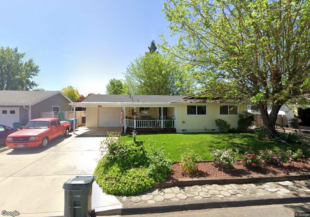
599 Sherman Way Eagle Point, OR 97524
Estimated Value: $318,111 - $333,000
3
Beds
2
Baths
1,122
Sq Ft
$289/Sq Ft
Est. Value
About This Home
This home is located at 599 Sherman Way, Eagle Point, OR 97524 and is currently estimated at $324,028, approximately $288 per square foot. 599 Sherman Way is a home located in Jackson County with nearby schools including Eagle Rock Elementary School, Eagle Point Middle School, and White Mountain Middle School.
Ownership History
Date
Name
Owned For
Owner Type
Purchase Details
Closed on
Jun 10, 2003
Sold by
Palmer R Dale and Palmer Arvalee D
Bought by
Chambers Thomas R and Chambers Sandra L
Current Estimated Value
Home Financials for this Owner
Home Financials are based on the most recent Mortgage that was taken out on this home.
Original Mortgage
$70,000
Outstanding Balance
$29,499
Interest Rate
5.61%
Mortgage Type
Purchase Money Mortgage
Estimated Equity
$294,529
Create a Home Valuation Report for This Property
The Home Valuation Report is an in-depth analysis detailing your home's value as well as a comparison with similar homes in the area
Home Values in the Area
Average Home Value in this Area
Purchase History
| Date | Buyer | Sale Price | Title Company |
|---|---|---|---|
| Chambers Thomas R | $100,000 | First American Title |
Source: Public Records
Mortgage History
| Date | Status | Borrower | Loan Amount |
|---|---|---|---|
| Open | Chambers Thomas R | $70,000 |
Source: Public Records
Tax History
| Year | Tax Paid | Tax Assessment Tax Assessment Total Assessment is a certain percentage of the fair market value that is determined by local assessors to be the total taxable value of land and additions on the property. | Land | Improvement |
|---|---|---|---|---|
| 2026 | $1,994 | $146,570 | -- | -- |
| 2025 | $1,947 | $142,310 | $76,540 | $65,770 |
| 2024 | $1,947 | $138,170 | $74,300 | $63,870 |
| 2023 | $1,881 | $134,150 | $72,140 | $62,010 |
| 2022 | $1,830 | $134,150 | $72,140 | $62,010 |
| 2021 | $1,776 | $130,250 | $70,050 | $60,200 |
| 2020 | $1,887 | $126,460 | $68,010 | $58,450 |
| 2019 | $1,858 | $119,210 | $64,110 | $55,100 |
| 2018 | $1,823 | $115,740 | $62,240 | $53,500 |
| 2017 | $1,778 | $115,740 | $62,240 | $53,500 |
| 2016 | $1,743 | $109,100 | $58,660 | $50,440 |
| 2015 | $1,686 | $109,100 | $58,660 | $50,440 |
| 2014 | $1,638 | $102,850 | $55,310 | $47,540 |
Source: Public Records
Map
Nearby Homes
- 71 Tracy Ave Unit 71 & 73
- 250 Tierra Cir
- 318 S Buchanan Ave
- 468 Merlee Cir
- 650 Sarah Ln
- 545 N Heights Dr
- 917 Stonewater Dr
- 911 Stonewater Dr
- 124 Paxon Ave
- 403 N Deanjou Ave
- 620 S Royal Ave
- 912 Stonewater Dr
- 0 Crater Lake Hwy
- 407 N Deanjou Ave
- 925 Sellwood Dr
- 0 Sf Little Butte Unit 220204792
- 1023 Highlands Dr
- 522 Meadow Ln
- 133 Edith Cir
- 110 Linton Way
Your Personal Tour Guide
Ask me questions while you tour the home.