
Seller's Agent in 2025
Adam Mancini
Ann McBride Real Estate
(860) 306-9988
79 in this area
196 Total Sales
Estimated Value: $405,000 - $424,000
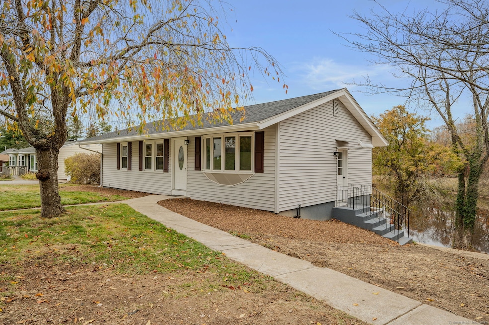
Stunning waterfront 3 BR, one bath Ranch in Aljen Heights offers fabulous waterviews of Poquetanuck Cove, an open floor plan with a remodeled kitchen featuring a center island, granite counters, and stainless steel appliances, a fully renovated bath with a tiled shower and glass door, and hardwood floors throughout the main level. There is a lower-level great room with recessed lights, composite floors, and a slider to a new composite deck overlooking the Cove. Updates include a new roof, a new septic tank, thermopane windows, and vinyl siding. Conveniently located within minutes of the Subase, Electric Boat, and major highways.
Last Agent to Sell the Property
Ann McBride Real Estate Brokerage Phone: (860) 306-9988 License #REB.0751610 Listed on: 11/06/2025
| Date | Buyer | Sale Price | Title Company |
|---|---|---|---|
| Hart Nicole | $425,000 | -- | |
| Arsenault Patricia A | -- | -- | |
| Linder Scott D | $132,000 | -- | |
| Obrien Gilbert F | $127,000 | -- |
| Date | Status | Borrower | Loan Amount |
|---|---|---|---|
| Open | Hart Nicole | $403,750 | |
| Previous Owner | Obrien Gilbert F | $105,600 | |
| Previous Owner | Obrien Gilbert F | $126,000 |
| Date | Event | Price | List to Sale | Price per Sq Ft |
|---|---|---|---|---|
| 12/06/2025 12/06/25 | Sold | $425,000 | 0.0% | $286 / Sq Ft |
| 11/10/2025 11/10/25 | Pending | -- | -- | -- |
| 11/06/2025 11/06/25 | For Sale | $424,900 | -- | $286 / Sq Ft |
| Year | Tax Paid | Tax Assessment Tax Assessment Total Assessment is a certain percentage of the fair market value that is determined by local assessors to be the total taxable value of land and additions on the property. | Land | Improvement |
|---|---|---|---|---|
| 2025 | $4,865 | $130,997 | $59,807 | $71,190 |
| 2024 | $4,612 | $130,997 | $59,807 | $71,190 |
| 2023 | $4,527 | $130,997 | $59,807 | $71,190 |
| 2022 | $4,430 | $130,997 | $59,807 | $71,190 |
| 2021 | $4,401 | $130,997 | $59,807 | $71,190 |
| 2020 | $4,250 | $121,520 | $53,830 | $67,690 |
| 2019 | $4,260 | $121,520 | $53,830 | $67,690 |
| 2018 | $4,167 | $121,520 | $53,830 | $67,690 |
| 2017 | $3,954 | $121,520 | $53,830 | $67,690 |
| 2016 | $3,876 | $121,520 | $53,830 | $67,690 |
| 2015 | $3,694 | $121,520 | $53,830 | $67,690 |
| 2014 | $3,857 | $129,010 | $53,830 | $75,180 |
Seller's Agent in 2025
Adam Mancini
Ann McBride Real Estate
(860) 306-9988
79 in this area
196 Total Sales
Buyer's Agent in 2025
Erica Kelly
RE/MAX
(860) 861-6064
4 in this area
53 Total Sales
Source: SmartMLS
MLS Number: 24109926
APN: LEDY-000003-000070-000006
Disclaimer: Certain information contained herein is derived from information provided by parties other than Homes.com. All information provided is deemed reliable, but is not guaranteed to be accurate and should be independently verified.
![]() IDX information is provided exclusively for personal, non-commercial use, and may not be used for any purpose other than to identify prospective properties consumers may be interested in purchasing. Information is deemed reliable but not guaranteed.
IDX information is provided exclusively for personal, non-commercial use, and may not be used for any purpose other than to identify prospective properties consumers may be interested in purchasing. Information is deemed reliable but not guaranteed.
Ask me questions while you tour the home.