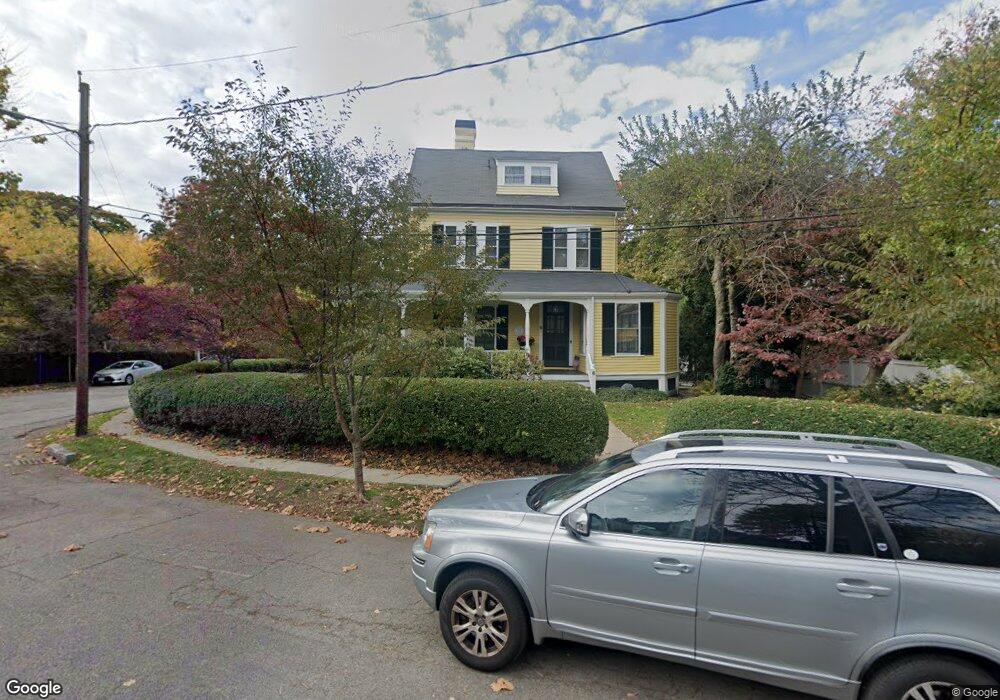
6 Mercer Cir Cambridge, MA 02138
West Cambridge NeighborhoodEstimated Value: $3,188,000 - $4,808,610
6
Beds
4
Baths
3,357
Sq Ft
$1,230/Sq Ft
Est. Value
About This Home
This home is located at 6 Mercer Cir, Cambridge, MA 02138 and is currently estimated at $4,128,870, approximately $1,229 per square foot. 6 Mercer Cir is a home located in Middlesex County with nearby schools including St Peter School, Cambridge Montessori School, and Buckingham Browne & Nichols School.
Ownership History
Date
Name
Owned For
Owner Type
Purchase Details
Closed on
Mar 9, 2017
Sold by
Porter Frank B
Bought by
Porter Nt
Current Estimated Value
Purchase Details
Closed on
Oct 14, 1982
Bought by
Porter Frank B
Create a Home Valuation Report for This Property
The Home Valuation Report is an in-depth analysis detailing your home's value as well as a comparison with similar homes in the area
Home Values in the Area
Average Home Value in this Area
Purchase History
| Date | Buyer | Sale Price | Title Company |
|---|---|---|---|
| Porter Nt | -- | -- | |
| Porter Frank B | -- | -- |
Source: Public Records
Tax History Compared to Growth
Tax History
| Year | Tax Paid | Tax Assessment Tax Assessment Total Assessment is a certain percentage of the fair market value that is determined by local assessors to be the total taxable value of land and additions on the property. | Land | Improvement |
|---|---|---|---|---|
| 2025 | $30,220 | $4,759,000 | $2,679,100 | $2,079,900 |
| 2024 | $27,519 | $4,648,500 | $2,657,600 | $1,990,900 |
| 2023 | $25,597 | $4,368,100 | $2,646,800 | $1,721,300 |
| 2022 | $23,283 | $3,932,900 | $2,426,900 | $1,506,000 |
| 2021 | $21,842 | $3,733,600 | $2,381,600 | $1,352,000 |
| 2020 | $20,470 | $3,560,000 | $2,279,200 | $1,280,800 |
| 2019 | $18,345 | $3,088,300 | $1,919,800 | $1,168,500 |
| 2018 | $19,025 | $3,024,600 | $1,910,000 | $1,114,600 |
| 2017 | $18,588 | $2,864,100 | $1,821,400 | $1,042,700 |
| 2016 | $17,373 | $2,485,400 | $1,575,200 | $910,200 |
| 2015 | $17,449 | $2,231,300 | $1,476,800 | $754,500 |
| 2014 | $18,282 | $2,181,600 | $1,437,400 | $744,200 |
Source: Public Records
Map
Nearby Homes
- 11 Brown St
- 15 Hubbard Park Rd
- 20 Maynard Place
- 48 Hubbard Park Rd
- 153 Brattle St
- 1010 Memorial Dr Unit 7D&E
- 158 Brattle St
- 3 Berkeley Place
- 32 Hawthorn St
- 12 Berkeley St
- 172 Brattle St
- 22 Concord Ave Unit 10
- 34 Ash St Unit 204
- 14 Concord Ave Unit 810/814
- 988 Memorial Dr Unit 386
- 5 Brewer St Unit 5
- 29 Concord Ave Unit 302
- 38 Garden St
- 44 Garden St
- 12 Ash Street Place
- 48 Sparks St
- 7 Mercer Cir
- 50 Sparks St
- 3 Hubbard Park Rd
- 5 Mercer Cir
- 3 Mercer Cir
- 8 Mercer Cir
- 47 Sparks St
- 0 Hubbard Park Rd Unit 1
- 2 Mercer Cir
- 4 Mercer Cir
- 2 Hubbard Park Rd
- 2 Hubbard Park Rd Unit 3
- 2 Hubbard Park Rd Unit 2
- 36 Sparks St Unit 2
- 36 Sparks St Unit 1
- 38 Sparks St
- 38 Sparks St Unit 1
- 134 Brattle St
- 136 Brattle St