C
Seller's Agent in 2013
Cathy Goudy
Seacoast Properties


Estimated Value: $1,452,000 - $1,582,000
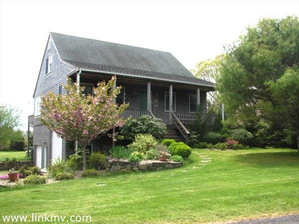
Custom built home located close to bike paths and the State Forest. This property has many features such as hardwood floors, walk out deck, farmer's porch and a large two car garage with enough room to store your boat! The yard is well landscaped with mature plantings and an under ground irrigation system. A perfect year round residence or a rental income producing property. Do not miss this opportunity.
Last Agent to Sell the Property
Cathy Goudy
Seacoast Properties Listed on: 05/17/2013
Last Buyer's Agent
Emma Kennedy
Sandpiper Realty
| Date | Buyer | Sale Price | Title Company |
|---|---|---|---|
| 6 Sparrow Lane Irt | -- | None Available | |
| Melaragni Francis | $540,000 | -- |
| Date | Status | Borrower | Loan Amount |
|---|---|---|---|
| Previous Owner | Melaragni Francis | $270,000 |
| Date | Event | Price | List to Sale | Price per Sq Ft |
|---|---|---|---|---|
| 07/11/2013 07/11/13 | Sold | $540,000 | -1.8% | $313 / Sq Ft |
| 05/25/2013 05/25/13 | Pending | -- | -- | -- |
| 05/17/2013 05/17/13 | For Sale | $549,900 | -- | $318 / Sq Ft |
| Year | Tax Paid | Tax Assessment Tax Assessment Total Assessment is a certain percentage of the fair market value that is determined by local assessors to be the total taxable value of land and additions on the property. | Land | Improvement |
|---|---|---|---|---|
| 2025 | $3,071 | $1,158,900 | $336,800 | $822,100 |
| 2024 | $2,671 | $1,047,600 | $336,800 | $710,800 |
| 2023 | $2,457 | $975,100 | $305,600 | $669,500 |
| 2022 | $2,205 | $727,700 | $305,600 | $422,100 |
| 2021 | $2,285 | $696,700 | $305,600 | $391,100 |
| 2020 | $2,172 | $648,400 | $277,900 | $370,500 |
| 2019 | $2,509 | $648,400 | $277,900 | $370,500 |
| 2018 | $2,176 | $562,400 | $277,900 | $284,500 |
| 2017 | $1,987 | $559,800 | $277,900 | $281,900 |
| 2016 | $1,911 | $528,000 | $276,700 | $251,300 |
| 2015 | $1,868 | $538,200 | $276,700 | $261,500 |
C
Seller's Agent in 2013
Cathy Goudy
Seacoast Properties
E
Buyer's Agent in 2013
Emma Kennedy
Sandpiper Realty
Source: LINK (Vineyard)
MLS Number: 24887
APN: EDGA-000010-000048