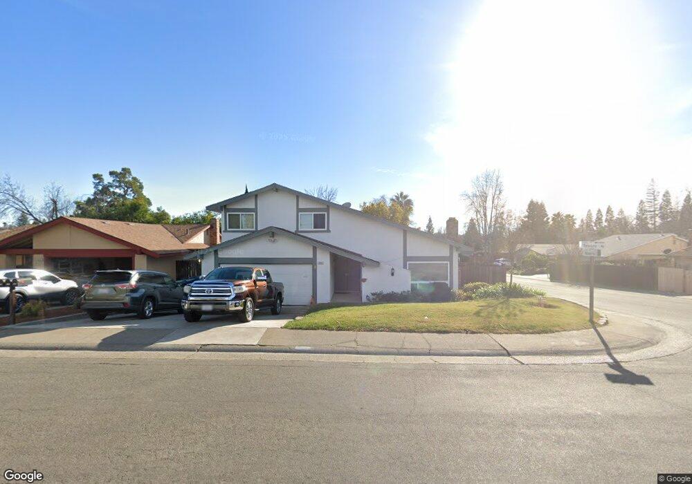
6000 Telesco Way Carmichael, CA 95608
Estimated Value: $521,000 - $574,000
4
Beds
3
Baths
1,814
Sq Ft
$301/Sq Ft
Est. Value
About This Home
This home is located at 6000 Telesco Way, Carmichael, CA 95608 and is currently estimated at $545,521, approximately $300 per square foot. 6000 Telesco Way is a home located in Sacramento County with nearby schools including Charles Peck Elementary School, Will Rogers Middle School, and Del Campo High School.
Ownership History
Date
Name
Owned For
Owner Type
Purchase Details
Closed on
Mar 21, 2007
Sold by
Foster Randall S
Bought by
Foster Randall S and Foster Deborah
Current Estimated Value
Home Financials for this Owner
Home Financials are based on the most recent Mortgage that was taken out on this home.
Original Mortgage
$107,000
Outstanding Balance
$64,943
Interest Rate
6.31%
Mortgage Type
New Conventional
Estimated Equity
$480,578
Purchase Details
Closed on
May 18, 1998
Sold by
Va
Bought by
Foster Randall S
Create a Home Valuation Report for This Property
The Home Valuation Report is an in-depth analysis detailing your home's value as well as a comparison with similar homes in the area
Home Values in the Area
Average Home Value in this Area
Purchase History
| Date | Buyer | Sale Price | Title Company |
|---|---|---|---|
| Foster Randall S | -- | Cornerstone Title Co | |
| Foster Randall S | -- | -- |
Source: Public Records
Mortgage History
| Date | Status | Borrower | Loan Amount |
|---|---|---|---|
| Open | Foster Randall S | $107,000 |
Source: Public Records
Tax History
| Year | Tax Paid | Tax Assessment Tax Assessment Total Assessment is a certain percentage of the fair market value that is determined by local assessors to be the total taxable value of land and additions on the property. | Land | Improvement |
|---|---|---|---|---|
| 2025 | $1,472 | $129,313 | $18,453 | $110,860 |
| 2024 | $1,472 | $126,779 | $18,092 | $108,687 |
| 2023 | $1,447 | $124,294 | $17,738 | $106,556 |
| 2022 | $1,417 | $121,858 | $17,391 | $104,467 |
| 2021 | $1,393 | $119,469 | $17,050 | $102,419 |
| 2020 | $1,366 | $118,245 | $16,876 | $101,369 |
| 2019 | $1,337 | $115,928 | $16,546 | $99,382 |
| 2018 | $1,321 | $113,656 | $16,222 | $97,434 |
| 2017 | $1,306 | $111,428 | $15,904 | $95,524 |
| 2016 | $1,220 | $109,244 | $15,593 | $93,651 |
| 2015 | $1,243 | $107,604 | $15,359 | $92,245 |
| 2014 | $1,217 | $105,499 | $15,059 | $90,440 |
Source: Public Records
Map
Nearby Homes
- 5935 Denver Dr
- 5861 Muldrow Rd
- 0 Secluded Oaks Ln Unit 224011893
- 5811 Muldrow Rd
- 5865 Esrig Way
- 5805 Muldrow Rd
- 5042 Greenberry Dr
- 5831 Verde Cruz Way
- 5106 Mckinney Way
- 4904 Manzanita Ave
- 6123 Longmont Way
- 5820 Shadow Creek Dr Unit 3
- 5122 Rhode Island Dr Unit 3
- 5642 Madison Ave Unit 3
- 5642 Madison Ave Unit 2
- 5642 Madison Ave
- 4907 Crestview Dr
- 5636 Madison Ave
- 6008 Rye Way
- 5309 Winfield Way Unit 4
- 6002 Telesco Way
- 5025 Willow Tree Ct
- 5916 Telesco Way
- 6004 Telesco Way
- 5024 Willow Tree Ct
- 5921 Telesco Way
- 6003 Telesco Way
- 5912 Telesco Way
- 5917 Telesco Way
- 6006 Telesco Way
- 5001 Willow Tree Ct
- 6005 Telesco Way
- 5020 Willow Tree Ct
- 5012 Willow Tree Ct
- 5008 Willow Tree Ct
- 5913 Telesco Way
- 5908 Telesco Way
- 5121 Columbine Way
- 5016 Willow Tree Ct
- 6008 Telesco Way
Your Personal Tour Guide
Ask me questions while you tour the home.