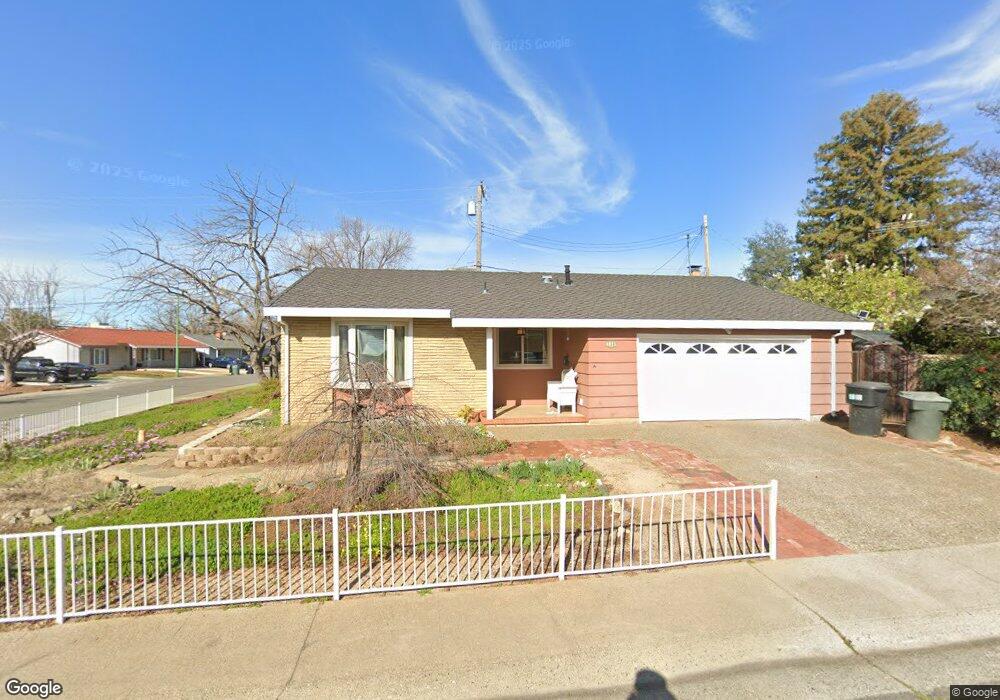
6021 Anthony Dr Orangevale, CA 95662
Estimated Value: $432,000 - $501,000
3
Beds
2
Baths
1,449
Sq Ft
$326/Sq Ft
Est. Value
About This Home
This home is located at 6021 Anthony Dr, Orangevale, CA 95662 and is currently estimated at $471,989, approximately $325 per square foot. 6021 Anthony Dr is a home located in Sacramento County with nearby schools including Twin Lakes Elementary School, Andrew Carnegie Middle School, and Bella Vista High School.
Ownership History
Date
Name
Owned For
Owner Type
Purchase Details
Closed on
Oct 26, 2006
Sold by
Ross Alice Louise
Bought by
Ross Alice Louise and The Alice Louise Ross Revocabl
Current Estimated Value
Home Financials for this Owner
Home Financials are based on the most recent Mortgage that was taken out on this home.
Original Mortgage
$105,000
Interest Rate
6.36%
Mortgage Type
New Conventional
Purchase Details
Closed on
Oct 19, 2006
Sold by
Ross Alice L
Bought by
Ross Alice Louise and Alice Louise Ross Revocable Tr
Home Financials for this Owner
Home Financials are based on the most recent Mortgage that was taken out on this home.
Original Mortgage
$105,000
Interest Rate
6.36%
Mortgage Type
New Conventional
Purchase Details
Closed on
Jul 15, 2005
Sold by
Ross Alice L
Bought by
Ross Alice Louise and Alice Louise Ross Revocable Tr
Create a Home Valuation Report for This Property
The Home Valuation Report is an in-depth analysis detailing your home's value as well as a comparison with similar homes in the area
Home Values in the Area
Average Home Value in this Area
Purchase History
| Date | Buyer | Sale Price | Title Company |
|---|---|---|---|
| Ross Alice Louise | -- | Old Republic Title Company | |
| Ross Alice Louise | -- | Old Republic Title Company | |
| Ross Alice Louise | -- | Old Republic Title Company | |
| Ross Alice L | -- | Old Republic Title Company | |
| Ross Alice Louise | -- | -- |
Source: Public Records
Mortgage History
| Date | Status | Borrower | Loan Amount |
|---|---|---|---|
| Closed | Ross Alice Louise | $105,000 | |
| Closed | Ross Alice L | $174,000 |
Source: Public Records
Tax History
| Year | Tax Paid | Tax Assessment Tax Assessment Total Assessment is a certain percentage of the fair market value that is determined by local assessors to be the total taxable value of land and additions on the property. | Land | Improvement |
|---|---|---|---|---|
| 2025 | $828 | $71,635 | $11,481 | $60,154 |
| 2024 | $828 | $70,231 | $11,256 | $58,975 |
| 2023 | $807 | $68,855 | $11,036 | $57,819 |
| 2022 | $802 | $67,506 | $10,820 | $56,686 |
| 2021 | $788 | $66,183 | $10,608 | $55,575 |
| 2020 | $774 | $65,506 | $10,500 | $55,006 |
| 2019 | $758 | $64,223 | $10,295 | $53,928 |
| 2018 | $748 | $62,965 | $10,094 | $52,871 |
| 2017 | $740 | $61,732 | $9,897 | $51,835 |
| 2016 | $694 | $60,522 | $9,703 | $50,819 |
| 2015 | $682 | $59,614 | $9,558 | $50,056 |
| 2014 | $668 | $58,456 | $9,379 | $49,077 |
Source: Public Records
Map
Nearby Homes
- 6132 Main Ave Unit 43
- 9350 River Oaks Ln
- 5947 Main Ave Unit A
- 5964 Sirl Way
- 9429 Erwin Ave
- 116 Raeanne Ln
- 9317 Dovewood Ct
- 9709 Snowberry Way
- 9340 Orangevale Ave Unit 26
- 9340 Orangevale Ave Unit 38
- 9340 Orangevale Ave Unit 27
- 124 Winding Canyon Ln
- 101 Silver Creek Ln
- 104 Winding Canyon Ln
- 5617 Walnut Ave Unit 15
- 9237 Madison Ave
- 9348 Blue Oak Dr
- 9112 Madison Green Ln Unit 22
- 117 Oak Rock Cir
- 5259 Dredger Way
- 6006 Keats Cir
- 6025 Anthony Dr
- 6054 Keats Cir
- 6020 Anthony Dr
- 6024 Anthony Dr
- 6015 Anthony Dr
- 6012 Keats Cir
- 6016 Anthony Dr
- 6028 Anthony Dr
- 6005 Keats Cir
- 6052 Keats Cir
- 6009 Keats Cir
- 6018 Keats Cir
- 6011 Anthony Dr
- 6055 Keats Cir
- 5943 Deary Way
- 6013 Keats Cir
- 6004 Anthony Dr
- 6032 Anthony Dr
- 5941 Deary Way
Your Personal Tour Guide
Ask me questions while you tour the home.