Estimated Value: $123,379 - $160,000
--
Bed
--
Bath
1,085
Sq Ft
$133/Sq Ft
Est. Value
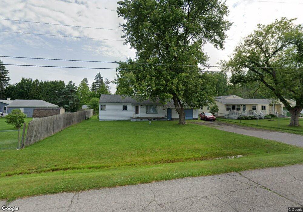
About This Home
This home is located at 6023 Bunker Hill St, Flint, MI 48506 and is currently estimated at $144,595, approximately $133 per square foot. 6023 Bunker Hill St is a home located in Genesee County with nearby schools including Weston Elementary School, Leota Fiedler Elementary School, and Kate Dowdall Elementary School.
Ownership History
Date
Name
Owned For
Owner Type
Purchase Details
Closed on
Jan 27, 2004
Sold by
Dimich Susan G
Bought by
Dimich Stanley and Dimich Susan G
Current Estimated Value
Home Financials for this Owner
Home Financials are based on the most recent Mortgage that was taken out on this home.
Original Mortgage
$71,200
Interest Rate
5.88%
Mortgage Type
New Conventional
Create a Home Valuation Report for This Property
The Home Valuation Report is an in-depth analysis detailing your home's value as well as a comparison with similar homes in the area
Home Values in the Area
Average Home Value in this Area
Purchase History
| Date | Buyer | Sale Price | Title Company |
|---|---|---|---|
| Dimich Stanley | -- | Sargents Title Company |
Source: Public Records
Mortgage History
| Date | Status | Borrower | Loan Amount |
|---|---|---|---|
| Closed | Dimich Stanley | $71,200 |
Source: Public Records
Tax History Compared to Growth
Tax History
| Year | Tax Paid | Tax Assessment Tax Assessment Total Assessment is a certain percentage of the fair market value that is determined by local assessors to be the total taxable value of land and additions on the property. | Land | Improvement |
|---|---|---|---|---|
| 2025 | $1,208 | $53,800 | $0 | $0 |
| 2024 | $296 | $49,600 | $0 | $0 |
| 2023 | $283 | $44,700 | $0 | $0 |
| 2022 | $990 | $42,000 | $0 | $0 |
| 2021 | $983 | $38,100 | $0 | $0 |
| 2020 | $259 | $34,600 | $0 | $0 |
| 2019 | $254 | $30,600 | $0 | $0 |
| 2018 | $933 | $27,800 | $0 | $0 |
| 2017 | $906 | $26,800 | $0 | $0 |
| 2016 | $903 | $25,800 | $0 | $0 |
| 2015 | $703 | $23,700 | $0 | $0 |
| 2014 | $235 | $22,100 | $0 | $0 |
| 2012 | -- | $19,600 | $19,600 | $0 |
Source: Public Records
Map
Nearby Homes
- 6077 Crown Point
- 4062 N Belsay Rd
- 6298 Nightingale Dr
- 6323 Bluejay Dr
- 6363 Bluejay Dr
- 3454 Eastdale Dr
- 5429 Hopkins Rd
- 4156 Bobwhite Dr
- 3389 Eastdale Dr
- 3365 Eastdale Dr
- 5142 Berneda Dr
- 5111 Paro Dr
- 5068 Roberts Dr
- 5335 Rose Ln
- 6443 Richfield Rd
- 5467 Richfield Rd
- 7020 E Carpenter Rd
- 4455 N Genesee Rd
- 3280 Lynne Ave
- 5141 N Vassar Rd
- 6031 Bunker Hill St
- 4260 N Belsay Rd
- 4266 N Belsay Rd
- 6041 Bunker Hill St
- 4286 N Belsay Rd
- 4242 N Belsay Rd
- 6022 Bunker Hill St
- 6049 Bunker Hill St
- 6034 Bunker Hill St
- 4236 N Belsay Rd
- 6055 Bunker Hill St
- 6042 Bunker Hill St
- 6050 Bunker Hill St
- 4300 N Belsay Rd
- 6025 Beacon Hill St
- 6063 Bunker Hill St
- 6031 Beacon Hill St
- 6037 Beacon Hill St
- 4226 N Belsay Rd
- 6066 Bunker Hill St