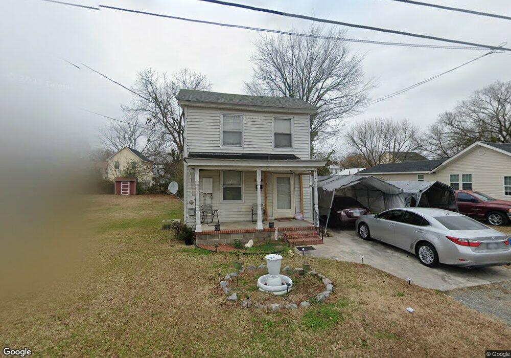
604 Battery Ave Suffolk, VA 23434
Holy Neck NeighborhoodEstimated Value: $106,000 - $256,000
3
Beds
1
Bath
1,312
Sq Ft
$128/Sq Ft
Est. Value
About This Home
This home is located at 604 Battery Ave, Suffolk, VA 23434 and is currently estimated at $167,409, approximately $127 per square foot. 604 Battery Ave is a home located in Suffolk City with nearby schools including Hillpoint Elementary School, Forest Glen Middle School, and Lakeland High School.
Ownership History
Date
Name
Owned For
Owner Type
Purchase Details
Closed on
Mar 8, 2019
Sold by
Smallwood Javoun
Bought by
Smallwood Properties Llc
Current Estimated Value
Home Financials for this Owner
Home Financials are based on the most recent Mortgage that was taken out on this home.
Original Mortgage
$22,200
Outstanding Balance
$19,744
Interest Rate
4.99%
Mortgage Type
Future Advance Clause Open End Mortgage
Estimated Equity
$147,665
Purchase Details
Closed on
Dec 5, 2017
Sold by
Smallwood Lottie M
Bought by
Matthews Kay and Smallwood Javoun
Create a Home Valuation Report for This Property
The Home Valuation Report is an in-depth analysis detailing your home's value as well as a comparison with similar homes in the area
Home Values in the Area
Average Home Value in this Area
Purchase History
| Date | Buyer | Sale Price | Title Company |
|---|---|---|---|
| Smallwood Properties Llc | -- | None Available | |
| Matthews Kay | -- | None Available |
Source: Public Records
Mortgage History
| Date | Status | Borrower | Loan Amount |
|---|---|---|---|
| Open | Smallwood Properties Llc | $22,200 |
Source: Public Records
Tax History Compared to Growth
Tax History
| Year | Tax Paid | Tax Assessment Tax Assessment Total Assessment is a certain percentage of the fair market value that is determined by local assessors to be the total taxable value of land and additions on the property. | Land | Improvement |
|---|---|---|---|---|
| 2024 | $1,224 | $70,700 | $36,800 | $33,900 |
| 2023 | $1,150 | $67,200 | $35,100 | $32,100 |
| 2022 | $566 | $51,900 | $25,100 | $26,800 |
| 2021 | $521 | $46,900 | $20,100 | $26,800 |
| 2020 | $473 | $42,600 | $18,200 | $24,400 |
| 2019 | $473 | $42,600 | $18,200 | $24,400 |
| 2018 | $614 | $43,400 | $18,200 | $25,200 |
| 2017 | $464 | $43,400 | $18,200 | $25,200 |
| 2016 | $464 | $43,400 | $18,200 | $25,200 |
| 2015 | $364 | $44,500 | $18,200 | $26,300 |
| 2014 | $364 | $44,500 | $18,200 | $26,300 |
Source: Public Records
Map
Nearby Homes
- 616 Ashley Ave
- 523 Mason Ave
- 515 Battery Ave
- 632 Brook Ave
- 707 Ashley Ave
- 529 S Broad St
- 461 Wellons St
- 717 Ashley Ave
- 435 Wellons St
- 433 Wellons St
- 411 Nevada St
- 419 Wellons St
- 418 Kilby Ave
- 406 Saint James Ave
- 814 Battery Ave
- 812 Battery Ave
- 317 Boat St
- 309 Linden Ave
- 308 Linden Ave
- 313 Saint James Ave
- 602 Battery Ave
- 608 Battery Ave
- 600 Battery Ave
- 601 Ashley Ave
- 607 Ashley Ave
- 532 Battery Ave
- 607 Battery Ave
- 603 Battery Ave
- 609 Ashley Ave
- 530 Battery Ave
- 616 Battery Ave
- 611 Battery Ave
- 529 Ashley Ave
- 613 Battery Ave
- 619 Ashley Ave
- 615 Battery Ave
- 527 Ashley Ave
- 529 Battery Ave
- 526 Battery Ave
- 622B Battery Ave