Estimated Value: $623,000 - $694,000
5
Beds
2
Baths
1,739
Sq Ft
$385/Sq Ft
Est. Value
About This Home
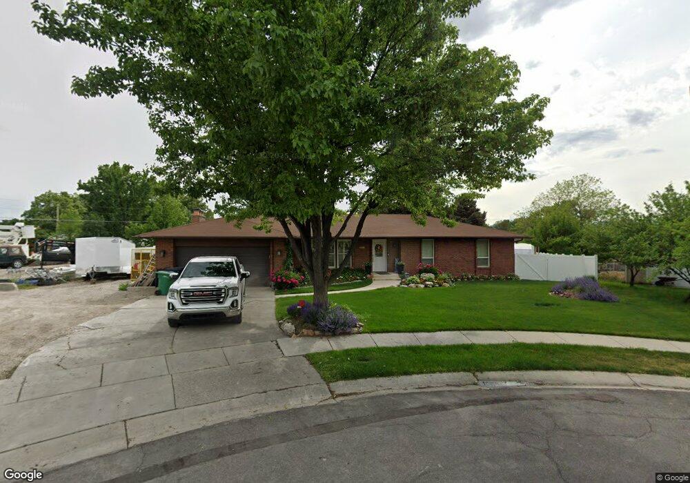
This home is located at 604 Faye Cir, Sandy, UT 84070 and is currently estimated at $669,461, approximately $384 per square foot. 604 Faye Cir is a home located in Salt Lake County with nearby schools including Mount Jordan Middle School, Jordan High, and Challenger School - Sandy.
Ownership History
Date
Name
Owned For
Owner Type
Purchase Details
Closed on
Jan 8, 2014
Sold by
Clark Brett M
Bought by
Clark Brett M and Clark Celeste
Current Estimated Value
Purchase Details
Closed on
Dec 18, 2012
Sold by
Clark Sanuna M
Bought by
Clark Brett M
Purchase Details
Closed on
Apr 27, 2010
Sold by
Clark Brett M
Bought by
Clark Sauna M
Purchase Details
Closed on
Aug 14, 2009
Sold by
Maxwell Byron S and Maxwell Verlyn G
Bought by
Clark Brett M and Clark Suna M
Purchase Details
Closed on
Jul 27, 2009
Sold by
Clark Brett M and Clark Sauna M
Bought by
Clark Brett M and Clark Sauna M
Purchase Details
Closed on
Sep 29, 2004
Sold by
Tueller Spencer E and Tueller Robyne
Bought by
Clark Brett M and Clark Sauna M
Create a Home Valuation Report for This Property
The Home Valuation Report is an in-depth analysis detailing your home's value as well as a comparison with similar homes in the area
Home Values in the Area
Average Home Value in this Area
Purchase History
| Date | Buyer | Sale Price | Title Company |
|---|---|---|---|
| Clark Brett M | -- | None Available | |
| Clark Brett M | -- | None Available | |
| Clark Sauna M | -- | Accommodation | |
| Clark Brett M | -- | None Available | |
| Clark Brett M | -- | None Available | |
| Clark Brett M | -- | Eagle Point Title |
Source: Public Records
Tax History
| Year | Tax Paid | Tax Assessment Tax Assessment Total Assessment is a certain percentage of the fair market value that is determined by local assessors to be the total taxable value of land and additions on the property. | Land | Improvement |
|---|---|---|---|---|
| 2025 | $3,386 | $639,500 | $266,300 | $373,200 |
| 2024 | $3,386 | $626,200 | $259,000 | $367,200 |
| 2023 | $3,022 | $557,200 | $235,400 | $321,800 |
| 2022 | $3,158 | $568,900 | $151,700 | $417,200 |
| 2021 | $2,834 | $434,600 | $116,400 | $318,200 |
| 2020 | $2,702 | $390,700 | $116,400 | $274,300 |
| 2019 | $2,575 | $362,900 | $109,900 | $253,000 |
| 2016 | $2,273 | $307,900 | $109,900 | $198,000 |
Source: Public Records
Map
Nearby Homes
- 9835 S 610 E
- 9822 S Darin Dr
- 487 E 9270 S
- 186 Brent Cir
- 9217 S Holiday Bowl Ct
- 362 E 9150 S
- 9203 S 220 E
- 409 E 10185 S
- 807 E Whisper Cove Rd
- 9587 S 1040 E
- 9957 Barium Ln
- 9092 Enchanted Oak Ln
- 956 E Sego Lily Dr
- 8915 S 660 E Unit 103
- 1133 E Wright Way
- 8475 S State St
- 1062 E Diamond Way
- 608 E 8800 S
- 8750 S 500 E
- 8812 S Cy's Park Ln Unit 6
- 604 E Faye Cir
- 9568 S Faye Cir
- 9568 S Faye Cir
- 565 E Wyandotte Ave
- 568 Floyd Dr
- 538 Dorothy Cir
- 565 Wyandotte Ave
- 606 Faye Cir
- 555 Wyandotte Ave
- 575 Wyandotte Ave
- 606 E Faye Cir
- 548 Dorothy Cir
- 585 Wyandotte Ave
- 547 Wyandotte Ave
- 575 E Wyandotte Ave
- 585 E Wyandotte Ave
- 608 Floyd Dr
- 531 E Wyandotte Ave
- 531 Wyandotte Ave
- 556 E Floyd Dr
Your Personal Tour Guide
Ask me questions while you tour the home.