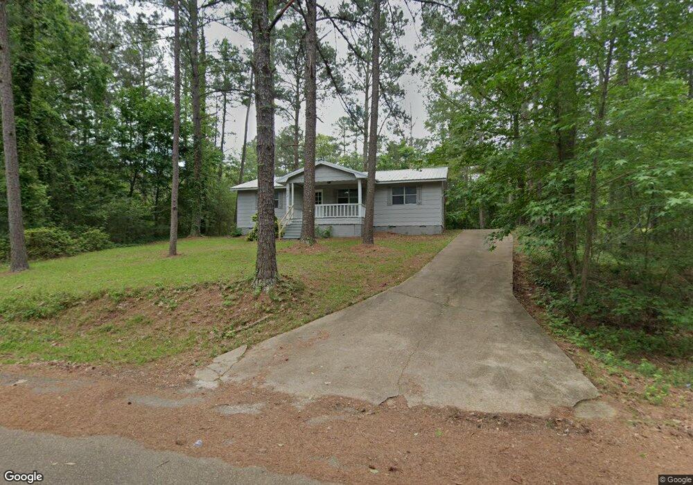
604 King Richard Rd Brandon, MS 39042
Estimated Value: $128,603 - $298,000
3
Beds
1
Bath
1,455
Sq Ft
$131/Sq Ft
Est. Value
About This Home
This home is located at 604 King Richard Rd, Brandon, MS 39042 and is currently estimated at $190,651, approximately $131 per square foot. 604 King Richard Rd is a home located in Rankin County with nearby schools including McLaurin Elementary School.
Ownership History
Date
Name
Owned For
Owner Type
Purchase Details
Closed on
Apr 30, 2025
Sold by
Mid South Lease & Sales Inc
Bought by
Amy Eversole Llc
Current Estimated Value
Home Financials for this Owner
Home Financials are based on the most recent Mortgage that was taken out on this home.
Original Mortgage
$3,200,000
Outstanding Balance
$3,086,445
Interest Rate
5.89%
Mortgage Type
Seller Take Back
Estimated Equity
-$2,895,794
Create a Home Valuation Report for This Property
The Home Valuation Report is an in-depth analysis detailing your home's value as well as a comparison with similar homes in the area
Purchase History
| Date | Buyer | Sale Price | Title Company |
|---|---|---|---|
| Amy Eversole Llc | -- | None Listed On Document | |
| Amy Eversole Llc | -- | None Listed On Document |
Source: Public Records
Mortgage History
| Date | Status | Borrower | Loan Amount |
|---|---|---|---|
| Open | Amy Eversole Llc | $3,200,000 |
Source: Public Records
Tax History
| Year | Tax Paid | Tax Assessment Tax Assessment Total Assessment is a certain percentage of the fair market value that is determined by local assessors to be the total taxable value of land and additions on the property. | Land | Improvement |
|---|---|---|---|---|
| 2025 | $1,021 | $9,410 | $0 | $0 |
| 2024 | $1,004 | $9,410 | $0 | $0 |
| 2023 | $650 | $6,089 | $0 | $0 |
| 2022 | $641 | $6,089 | $0 | $0 |
| 2021 | $641 | $6,089 | $0 | $0 |
| 2020 | $641 | $6,089 | $0 | $0 |
| 2019 | $575 | $5,321 | $0 | $0 |
| 2018 | $564 | $5,321 | $0 | $0 |
| 2017 | $564 | $5,321 | $0 | $0 |
| 2016 | $513 | $5,082 | $0 | $0 |
| 2015 | $513 | $5,082 | $0 | $0 |
| 2014 | $502 | $5,082 | $0 | $0 |
| 2013 | $502 | $5,082 | $0 | $0 |
Source: Public Records
Map
Nearby Homes
- 0 Sir Guy Ln
- 110 Sir Richard Rd
- 112 Sir Richard Rd
- 1142 Sanctuary Dr
- 0 Will Stutely Dr
- 321 Stronghold Dr
- 312 Stronghold Dr
- 310 Stronghold Dr
- 308 Stronghold Dr
- 217 New Haven Ln
- 538 Stone Brook Place
- 325 Stronghold Dr
- 536 Stone Brook Place
- 532 Stone Brook Place
- 528 Stone Brook Place
- 511 Stone Brook Place
- 509 Stone Brook Place
- 504 Stone Brook Place
- 508 Stone Brook Place
- 1622 Old Lake Rd
- 607 King Richard Rd
- 162 Sunset St
- 613 King Richard Rd
- 139 Sunset St
- 137 Lady Marian Rd
- 145 Sherwood Ln
- 136 Lady Marian Rd
- 606 King Richard Rd
- 129 Sylvan Dr
- 51 Sherwood Forest
- 607 Sunset St
- 615 King Richard Rd
- 146 Sherwood Ln
- 129 Sir Guy Ln
- 120 Sherwood Ln
- 0 Lake Side Dr
- 0 Sherwood Ln Unit 1247456
- 0 Sherwood Ln Unit 247456
- 151 King Richard Rd
- 00 Lake Side Dr
Your Personal Tour Guide
Ask me questions while you tour the home.