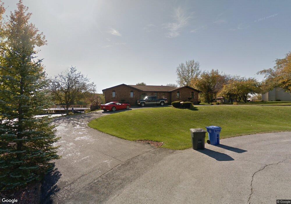
605 W 128th Ct Crown Point, IN 46307
Estimated Value: $488,000 - $544,000
3
Beds
3
Baths
2,737
Sq Ft
$188/Sq Ft
Est. Value
About This Home
This home is located at 605 W 128th Ct, Crown Point, IN 46307 and is currently estimated at $514,531, approximately $187 per square foot. 605 W 128th Ct is a home located in Lake County with nearby schools including Dwight D. Eisenhower Elementary School, Colonel John Wheeler Middle School, and Crown Point High School.
Ownership History
Date
Name
Owned For
Owner Type
Purchase Details
Closed on
Jun 18, 2010
Sold by
Sartori Richard and Sartori Theresa
Bought by
Poulter Randall J and Poulter Carrie L
Current Estimated Value
Home Financials for this Owner
Home Financials are based on the most recent Mortgage that was taken out on this home.
Original Mortgage
$304,894
Outstanding Balance
$209,579
Interest Rate
5.5%
Mortgage Type
FHA
Estimated Equity
$304,952
Create a Home Valuation Report for This Property
The Home Valuation Report is an in-depth analysis detailing your home's value as well as a comparison with similar homes in the area
Home Values in the Area
Average Home Value in this Area
Purchase History
| Date | Buyer | Sale Price | Title Company |
|---|---|---|---|
| Poulter Randall J | -- | Community Title Company |
Source: Public Records
Mortgage History
| Date | Status | Borrower | Loan Amount |
|---|---|---|---|
| Open | Poulter Randall J | $304,894 |
Source: Public Records
Tax History Compared to Growth
Tax History
| Year | Tax Paid | Tax Assessment Tax Assessment Total Assessment is a certain percentage of the fair market value that is determined by local assessors to be the total taxable value of land and additions on the property. | Land | Improvement |
|---|---|---|---|---|
| 2024 | $8,652 | $422,600 | $75,900 | $346,700 |
| 2023 | $3,977 | $407,100 | $75,900 | $331,200 |
| 2022 | $4,195 | $388,900 | $75,900 | $313,000 |
| 2021 | $3,454 | $342,800 | $60,500 | $282,300 |
| 2020 | $3,510 | $331,600 | $60,500 | $271,100 |
| 2019 | $3,497 | $322,200 | $60,500 | $261,700 |
| 2018 | $3,674 | $316,400 | $60,500 | $255,900 |
| 2017 | $3,667 | $312,200 | $60,500 | $251,700 |
| 2016 | $3,663 | $309,900 | $60,500 | $249,400 |
| 2014 | $3,301 | $300,200 | $60,500 | $239,700 |
| 2013 | $3,102 | $289,200 | $60,500 | $228,700 |
Source: Public Records
Map
Nearby Homes
- 253 W 129th Ave Unit 1
- 300 W 128th Place
- 809 W 126th Ct
- 183 W 126th Ave
- 12566 Massachusetts St
- 1433 Rainy Brook Way
- 12492 Washington St
- 557 E 130th Place
- 12929 Delaware St
- 12819 Grant St
- S-3142-3 Willow Plan at The Willows - Single Family Homes
- S-1965-3 Sage Plan at The Willows - Single Family Homes
- 499 E 131st Place
- 13115 Carolina St
- 13070 Carolina St
- T-1356 Wyatt Plan at The Willows - Townhomes
- S-2820-3 Rowan Plan at The Willows - Single Family Homes
- S-1654-3 Blakely Plan at The Willows - Single Family Homes
- S-2444-3 Sedona Plan at The Willows - Single Family Homes
- S-2353-3 Aspen Plan at The Willows - Single Family Homes
- 649 W 128th Ct
- 12852 Monroe St
- 12874 Monroe St
- 12830 Monroe St
- 12857 Van Buren St
- 596 W 128th Ct
- 524 W 129th Ave
- 638 W 129th Ave
- 648 W 128th Ct
- 12813 Van Buren St
- 12808 Monroe St
- 12878 Van Buren St
- 12875 Monroe St
- 12831 Monroe St
- 12856 Van Buren St
- 12786 Monroe St
- 12887 Monroe St
- 653 W 127th Place
- 7215 W 129th Ave
- 253 W 129th Ave