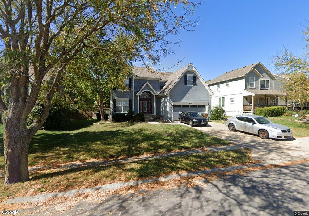
606 S Adams St Raymore, MO 64083
Estimated Value: $372,000 - $409,000
3
Beds
2
Baths
2,234
Sq Ft
$174/Sq Ft
Est. Value
About This Home
This home is located at 606 S Adams St, Raymore, MO 64083 and is currently estimated at $387,985, approximately $173 per square foot. 606 S Adams St is a home located in Cass County with nearby schools including Raymore Elementary School, Raymore-Peculiar East Middle School, and Raymore-Peculiar Senior High School.
Ownership History
Date
Name
Owned For
Owner Type
Purchase Details
Closed on
Aug 24, 2007
Sold by
Goforth Philip E and Goforth Amy E
Bought by
Reed Willis and Reed Amber
Current Estimated Value
Purchase Details
Closed on
Feb 4, 2005
Sold by
Goforth Phillip E and Goforth Amy E
Bought by
Goforth Philip E and Goforth Amy E
Home Financials for this Owner
Home Financials are based on the most recent Mortgage that was taken out on this home.
Original Mortgage
$188,100
Interest Rate
7.25%
Mortgage Type
Adjustable Rate Mortgage/ARM
Create a Home Valuation Report for This Property
The Home Valuation Report is an in-depth analysis detailing your home's value as well as a comparison with similar homes in the area
Home Values in the Area
Average Home Value in this Area
Purchase History
| Date | Buyer | Sale Price | Title Company |
|---|---|---|---|
| Reed Willis | -- | -- | |
| Goforth Philip E | -- | -- |
Source: Public Records
Mortgage History
| Date | Status | Borrower | Loan Amount |
|---|---|---|---|
| Previous Owner | Goforth Philip E | $188,100 |
Source: Public Records
Tax History Compared to Growth
Tax History
| Year | Tax Paid | Tax Assessment Tax Assessment Total Assessment is a certain percentage of the fair market value that is determined by local assessors to be the total taxable value of land and additions on the property. | Land | Improvement |
|---|---|---|---|---|
| 2025 | $3,605 | $49,620 | $5,960 | $43,660 |
| 2024 | $3,605 | $44,300 | $5,420 | $38,880 |
| 2023 | $3,600 | $44,300 | $5,420 | $38,880 |
| 2022 | $3,219 | $39,350 | $5,420 | $33,930 |
| 2021 | $3,220 | $39,350 | $5,420 | $33,930 |
| 2020 | $3,215 | $38,590 | $5,420 | $33,170 |
| 2019 | $3,103 | $38,590 | $5,420 | $33,170 |
| 2018 | $2,822 | $33,890 | $4,510 | $29,380 |
| 2017 | $2,578 | $33,890 | $4,510 | $29,380 |
| 2016 | $2,578 | $32,130 | $4,510 | $27,620 |
| 2015 | $2,579 | $32,130 | $4,510 | $27,620 |
| 2014 | $2,581 | $32,130 | $4,510 | $27,620 |
| 2013 | -- | $32,130 | $4,510 | $27,620 |
Source: Public Records
Map
Nearby Homes
- 512 S Washington St
- 605 S Franklin St
- 507 S Washington St
- 302 E Olive St
- 528 S Saturn Dr
- 526 S Saturn Dr
- 204 N Pointe Ln
- 112 W Grant Dr
- 222 N Madison St
- 700 E Saturn Dr
- 221 N Pointe Ln
- 105 N Lakeshore Dr
- 901 W Lucy Webb Rd
- 808 Clancy Ct
- 108 Rainbow Cir
- 227 N Woodson Dr
- 0 Rd Unit HMS2556766
- 0 J Hwy & Lucy Webb Rd Unit HMS2556862
- 1108 Yokley Dr
- 208 N Pacific Ct
- 604 S Adams St
- 608 S Adams St
- 602 S Adams St
- 607 S Adams St
- 609 S Adams St
- 600 S Adams St
- 612 S Adams St
- 605 S Adams St
- 603 S Adams St
- 607 Derby St
- 336 W Cottonwood Dr
- 614 S Adams St
- 609 Derby St
- 603 Derby St
- 601 S Adams St
- 324 W Cottonwood Dr
- 611 Derby St
- 332 W Cottonwood Dr
- 326 W Cottonwood Dr
- 328 W Cottonwood Dr