60639 211th St Eagle Lake, MN 56024
Estimated payment $5,196/month
Highlights
- RV Access or Parking
- Fireplace in Primary Bedroom
- No HOA
- Wolf Appliances
- Mud Room
- Farmhouse Sink
About This Home
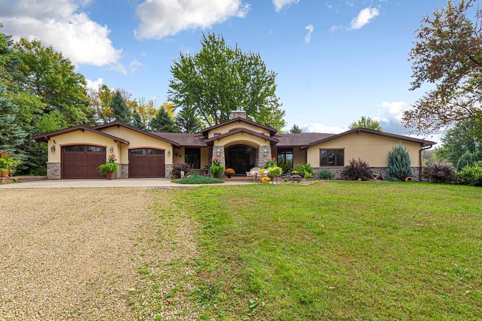
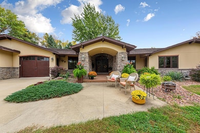
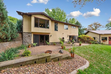
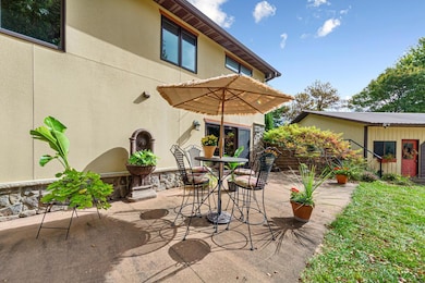
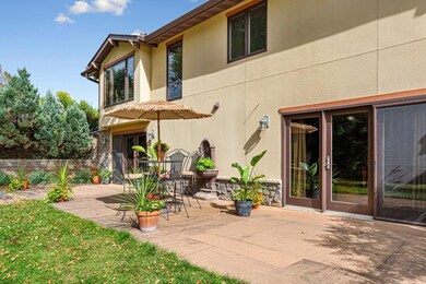
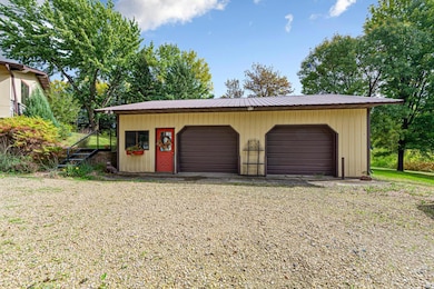
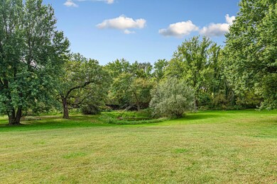
Stunning 4-Acre Retreat with Custom Finishes & Shop Space-- Welcome to this one-of-a-kind property where luxury meets functionality in Eagle Lake! Situated on nearly 4 beautiful acres, this 3-bedroom, 4-bathroom home showcases custom finishes throughout, blending timeless craftsmanship with modern comfort. Built to reflect the owners love of Spanish style homes, this home features a stunning stucco and brick exterior, with arches, abundant patio spaces, gardens and more. Step inside to the entry featuring a floor to ceiling dual sided fireplace, custom doors and pure elegance. A chef’s kitchen designed for entertaining, showcasing a Wolf Gas Cooktop (4 burners, grill and griddle) and a show stopping custom range hood. Also in the kitchen are custom concrete countertops, a farmhouse sink, hidden refrigerator drawer space, and Plato knotty alder custom cabinets soaring from floor to ceiling. Abundant prep and storage space on either side of the kitchen open to the butler pantry where you will find a Kenmore Elite double oven, a double refrigerator and freezer combo and additional prep space, while the other side of the kitchen opens to a refreshment room, where guests can enjoy libations and company. The open layout flows seamlessly into inviting living and dining areas on respective sides, with indoor-outdoor connections everywhere—perfect for gathering or quiet relaxation. The extensive main floor primary suite features brand new carpeting, a gas fireplace, patio doors opening to a cozy patio space, large primary closet and stunning full bathroom. Additionally, the main floor includes another main floor bath, a bedroom or office, and a full laundry/mudroom area right off the garage. The lower level is an entertainer's dream, with a massive living space, a custom bar with Cherry Creek Crystal Cabinets and updated LVT flooring, an additional bedroom with its own patio doors, two additional full bathrooms, an expansive room ready to be finished for an entertainment space, and ample storage! The home includes a two-stall attached garage, plus a pole shed with two additional stalls and shop space, ideal for hobbyists, storage, or business needs. Outside, the property is a gardener’s dream, with gardens and thoughtfully designed patio spaces that let you enjoy the outdoors from every angle. With space, style, and versatility, this property offers endless opportunities to live, work, and play—all in one exceptional setting.
Home Details
Home Type
- Single Family
Est. Annual Taxes
- $8,712
Year Built
- Built in 1980
Lot Details
- 3.99 Acre Lot
- Lot Dimensions are 270x644
- Many Trees
Parking
- 2 Car Attached Garage
- Garage Door Opener
- Shared Driveway
- Parking Garage Space
- RV Access or Parking
Home Design
- Unfinished Walls
- Architectural Shingle Roof
Interior Spaces
- 1-Story Property
- Wet Bar
- Mud Room
- Family Room with Fireplace
- 3 Fireplaces
- Living Room with Fireplace
- Sitting Room
- Dining Room
Kitchen
- Built-In Double Oven
- Range
- Microwave
- Freezer
- Dishwasher
- Wine Cooler
- Wolf Appliances
- Stainless Steel Appliances
- Farmhouse Sink
Bedrooms and Bathrooms
- 3 Bedrooms
- Fireplace in Primary Bedroom
Laundry
- Laundry Room
- Dryer
- Washer
Partially Finished Basement
- Walk-Out Basement
- Basement Fills Entire Space Under The House
- Drainage System
- Sump Pump
- Drain
- Block Basement Construction
- Basement Storage
Utilities
- Forced Air Heating and Cooling System
- Vented Exhaust Fan
- Underground Utilities
- Private Water Source
- Shared Water Source
- Well
- Drilled Well
- Gas Water Heater
- Water Softener is Owned
- Septic System
Additional Features
- Air Exchanger
- Patio
Community Details
- No Home Owners Association
Listing and Financial Details
- Assessor Parcel Number R391020100011
Map
Home Values in the Area
Average Home Value in this Area
Tax History
| Year | Tax Paid | Tax Assessment Tax Assessment Total Assessment is a certain percentage of the fair market value that is determined by local assessors to be the total taxable value of land and additions on the property. | Land | Improvement |
|---|---|---|---|---|
| 2025 | $8,732 | $795,000 | $90,000 | $705,000 |
| 2024 | $7,872 | $808,400 | $90,700 | $717,700 |
| 2023 | $8,024 | $745,500 | $90,300 | $655,200 |
| 2022 | $7,226 | $693,700 | $88,900 | $604,800 |
| 2021 | $5,390 | $562,600 | $88,100 | $474,500 |
| 2020 | $5,088 | $482,600 | $74,600 | $408,000 |
| 2019 | $4,692 | $482,600 | $74,600 | $408,000 |
| 2018 | $4,278 | $436,900 | $73,900 | $363,000 |
| 2017 | $3,942 | $418,500 | $74,600 | $343,900 |
| 2016 | $3,586 | $380,300 | $74,600 | $305,700 |
| 2015 | $33 | $341,400 | $57,500 | $283,900 |
| 2014 | $4,272 | $344,300 | $57,500 | $286,800 |
Property History
| Date | Event | Price | List to Sale | Price per Sq Ft |
|---|---|---|---|---|
| 11/04/2025 11/04/25 | For Sale | $849,000 | -- | $214 / Sq Ft |
Source: NorthstarMLS
MLS Number: 6813678
APN: R39-10-20-100-011
Disclaimer: Certain information contained herein is derived from information provided by parties other than Homes.com. All information provided is deemed reliable, but is not guaranteed to be accurate and should be independently verified.
![]() Based on information submitted to the MLS GRID. All data is obtained from various sources and may not have been verified by broker or MLS GRID. Supplied Open House Information is subject to change without notice. All information should be independently reviewed and verified for accuracy. Properties may or may not be listed by the office/agent presenting the information. Some IDX listings have been excluded from this website.
Based on information submitted to the MLS GRID. All data is obtained from various sources and may not have been verified by broker or MLS GRID. Supplied Open House Information is subject to change without notice. All information should be independently reviewed and verified for accuracy. Properties may or may not be listed by the office/agent presenting the information. Some IDX listings have been excluded from this website.
The Digital Millennium Copyright Act of 1998, 17 U.S.C. § 512 (the “DMCA”) provides recourse for copyright owners who believe that material appearing on the Internet infringes their rights under U.S. copyright law. If you believe in good faith that any content or material made available in connection with our website or services infringes your copyright, you (or your agent) may send us a notice requesting that the content or material be removed, or access to it blocked.
Notices must be sent in writing by email to DMCAnotice@MLSGrid.com.
The DMCA requires that your notice of alleged copyright infringement include the following information:
(1) description of the copyrighted work that is the subject of claimed infringement;
(2) description of the alleged infringing content and information sufficient to permit us to locate the content;
(3) contact information for you, including your address, telephone number and email address;
(4) a statement by you that you have a good faith belief that the content in the manner complained of is not authorized by the copyright owner, or its agent, or by the operation of any law;
(5) a statement by you, signed under penalty of perjury, that the information in the notification is accurate and that you have the authority to enforce the copyrights that are claimed to be infringed; and
(6) a physical or electronic signature of the copyright owner or a person authorized to act on the copyright owner’s behalf. Failure to include all of the above information may result in the delay of the processing of your complaint.
- 60451 211th St
- 0 Tbd Oak Dr
- 0 White Fox Path Unit 7038988
- 0 White Fox Path Unit 7038991
- 0 White Fox Path Unit 7038990
- 0 White Fox Path Unit 7038989
- 0 White Fox Path Unit 7038987
- 105 Gray Fox Path
- 0 Gray Fox Path Unit 7038986
- 0 Gray Fox Path Unit 7038985
- 0 Gray Fox Path Unit 7038984
- XXX 602nd Ave
- 602nd Avenue
- 106 Connie Ln Unit 106 Connie Lane E
- 220 Connie Ln
- 405 Thomas Dr
- 112 S 3rd St
- 205 Peregrine Ave
- 513 Linda Dr
- 121 Hawk Ave
- 100 Maple Ln
- 103 Connie Ln E
- 138 N Agency St Unit 3
- 101 Eagle Path Unit 1
- 101 Linda Path
- 906 Point Pleasant Rd Unit 906
- 161-351 E Roosevelt Cir
- 2217-2361 Links St
- 2325 Excel Dr
- 1570 Stadium Ln Unit 1
- 210 Thomas Dr
- 100-104 Thomas Dr
- 701 S Victory Dr
- 123 Jaybee Ln Unit 124
- 121 Jaybee Ln Unit 123
- 185 Heather Ln
- 203 Karu Dr Unit 191
- 1690 Premier Dr
- 111 Redtail Ct
- 103 Bardin Dr Unit 104
