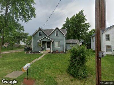
6064 Linden St Lehigh, IA 50557
Estimated Value: $61,000 - $124,000
4
Beds
1
Bath
1,132
Sq Ft
$81/Sq Ft
Est. Value
About This Home
This home is located at 6064 Linden St, Lehigh, IA 50557 and is currently estimated at $91,698, approximately $81 per square foot. 6064 Linden St is a home located in Webster County with nearby schools including Dayton Center and Southeast Webster-Grand Southeast Valley Middle School.
Ownership History
Date
Name
Owned For
Owner Type
Purchase Details
Closed on
Sep 16, 2022
Sold by
Rude John P
Bought by
Rude Melissa L
Current Estimated Value
Purchase Details
Closed on
Oct 29, 2009
Sold by
Tuel Joseph B and Tuel Ashley K
Bought by
Rude Melissa L
Home Financials for this Owner
Home Financials are based on the most recent Mortgage that was taken out on this home.
Original Mortgage
$45,706
Interest Rate
5.07%
Mortgage Type
FHA
Purchase Details
Closed on
Jan 20, 2007
Sold by
Anderson Karla J
Bought by
Tuel Joseph B and Cummins Ashley K
Home Financials for this Owner
Home Financials are based on the most recent Mortgage that was taken out on this home.
Original Mortgage
$43,832
Interest Rate
6.21%
Mortgage Type
FHA
Create a Home Valuation Report for This Property
The Home Valuation Report is an in-depth analysis detailing your home's value as well as a comparison with similar homes in the area
Home Values in the Area
Average Home Value in this Area
Purchase History
| Date | Buyer | Sale Price | Title Company |
|---|---|---|---|
| Rude Melissa L | -- | -- | |
| Rude Melissa L | $47,000 | None Available | |
| Tuel Joseph B | $41,500 | None Available |
Source: Public Records
Mortgage History
| Date | Status | Borrower | Loan Amount |
|---|---|---|---|
| Previous Owner | Rude Melissa L | $45,706 | |
| Previous Owner | Tuel Joseph B | $43,832 |
Source: Public Records
Tax History Compared to Growth
Tax History
| Year | Tax Paid | Tax Assessment Tax Assessment Total Assessment is a certain percentage of the fair market value that is determined by local assessors to be the total taxable value of land and additions on the property. | Land | Improvement |
|---|---|---|---|---|
| 2024 | $8 | $55,660 | $3,230 | $52,430 |
| 2023 | $778 | $55,660 | $3,230 | $52,430 |
| 2022 | $806 | $48,670 | $3,230 | $45,440 |
| 2021 | $790 | $48,670 | $3,230 | $45,440 |
| 2020 | $790 | $43,490 | $3,230 | $40,260 |
| 2019 | $800 | $46,110 | $3,190 | $42,920 |
| 2018 | $810 | $41,920 | $2,900 | $39,020 |
| 2017 | $746 | $37,820 | $0 | $0 |
| 2016 | $768 | $37,820 | $0 | $0 |
| 2015 | $768 | $37,820 | $0 | $0 |
| 2014 | $792 | $37,820 | $0 | $0 |
Source: Public Records
Map
Nearby Homes
- 475 Bluff St
- 359 E Main St
- 0 Racine Ave
- 000 Racine Ave
- TBD Quail Ave
- 2586 310th St
- 3111 Taylor Ave
- 2823 280th St
- 2427 Woodmans Hollow Rd
- 502 3rd St NE
- 102 5th Ave NW
- 1914251008 Parcel Nos 1914251008 and 1914251003
- 24 4th Ave NE
- 301 2nd Ave NE
- 104 N Main St
- 2141 320th St
- 2414 Poplar Ave
- 308 3rd Ave SW
- 2417 240th St
- 3090 Stagecoach Rd