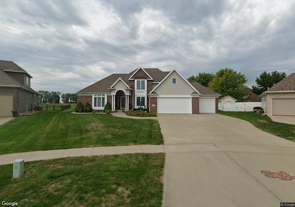
607 Winfield Cir Sergeant Bluff, IA 51054
Estimated Value: $434,000 - $523,000
4
Beds
2
Baths
3,022
Sq Ft
$156/Sq Ft
Est. Value
About This Home
This home is located at 607 Winfield Cir, Sergeant Bluff, IA 51054 and is currently estimated at $472,176, approximately $156 per square foot. 607 Winfield Cir is a home located in Woodbury County with nearby schools including Sergeant Bluff-Luton Primary School, Sergeant Bluff-Luton Elementary School, and Sergeant Bluff-Luton Middle School.
Ownership History
Date
Name
Owned For
Owner Type
Purchase Details
Closed on
Mar 23, 2007
Sold by
Brenden Diane E and Haindfield Diane E
Bought by
Haindfield Diane E
Current Estimated Value
Home Financials for this Owner
Home Financials are based on the most recent Mortgage that was taken out on this home.
Original Mortgage
$25,000
Interest Rate
6.31%
Mortgage Type
Credit Line Revolving
Create a Home Valuation Report for This Property
The Home Valuation Report is an in-depth analysis detailing your home's value as well as a comparison with similar homes in the area
Home Values in the Area
Average Home Value in this Area
Purchase History
| Date | Buyer | Sale Price | Title Company |
|---|---|---|---|
| Haindfield Diane E | -- | -- |
Source: Public Records
Mortgage History
| Date | Status | Borrower | Loan Amount |
|---|---|---|---|
| Closed | Haindfield Diane E | $25,000 |
Source: Public Records
Tax History
| Year | Tax Paid | Tax Assessment Tax Assessment Total Assessment is a certain percentage of the fair market value that is determined by local assessors to be the total taxable value of land and additions on the property. | Land | Improvement |
|---|---|---|---|---|
| 2025 | $7,324 | $508,200 | $50,420 | $457,780 |
| 2024 | $71 | $485,070 | $52,440 | $432,630 |
| 2023 | $7,604 | $485,070 | $52,440 | $432,630 |
| 2022 | $7,538 | $441,630 | $52,440 | $389,190 |
| 2021 | $7,538 | $441,630 | $52,440 | $389,190 |
| 2020 | $6,268 | $367,900 | $56,110 | $311,790 |
| 2019 | $6,172 | $361,700 | $56,110 | $305,590 |
| 2018 | $6,020 | $351,180 | $45,590 | $305,590 |
| 2017 | $6,020 | $351,180 | $45,590 | $305,590 |
| 2016 | $6,652 | $351,180 | $0 | $0 |
| 2015 | $6,557 | $328,210 | $42,610 | $285,600 |
| 2014 | $6,186 | $328,210 | $42,610 | $285,600 |
Source: Public Records
Map
Nearby Homes
- 605 Winfield Cir
- 609 Winfield Cir
- 603 Winfield Cir
- 611 Winfield Cir
- 510 Baywood Ct
- 608 Winfield Cir
- 509 Baywood Ct
- 601 Winfield Cir
- 610 Winfield Cir
- 613 Winfield Cir
- 511 Embassy Dr
- 507 Baywood Ct
- 612 Winfield Cir
- 508 Baywood Ct
- 615 Winfield Cir
- 409 Winfield Cir
- 614 Winfield Cir
- 507 Embassy Dr
- 505 Baywood Ct
- 506 Baywood Ct
Your Personal Tour Guide
Ask me questions while you tour the home.