Estimated Value: $203,000 - $215,000
4
Beds
2
Baths
1,872
Sq Ft
$112/Sq Ft
Est. Value
About This Home
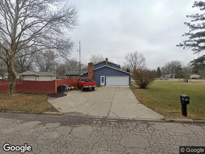
This home is located at 6074 W Court St, Flint, MI 48532 and is currently estimated at $210,165, approximately $112 per square foot. 6074 W Court St is a home located in Genesee County with nearby schools including Carman-Ainsworth High School, Genesee STEM Academy, and First Flint Seventh-day Adventist Christian School.
Ownership History
Date
Name
Owned For
Owner Type
Purchase Details
Closed on
May 24, 2006
Sold by
Goodman Johnnie and Goodman Curtis Eta
Bought by
Tyler Mark A and Tyler Angela R
Current Estimated Value
Purchase Details
Closed on
Nov 3, 2005
Sold by
Mortgage Electronic Registration Systems
Bought by
Goodman Johnnie
Purchase Details
Closed on
Aug 4, 2004
Sold by
Mortgage Electronic Registration Systems
Bought by
Federal National Mortgage Association
Purchase Details
Closed on
Jul 28, 2004
Sold by
Adams Richard and Spinnato Tricia R
Bought by
Mortgage Electronic Registration Systems
Purchase Details
Closed on
Jul 31, 2002
Sold by
Spinnato Tricia R and Adams Richard
Bought by
Mortgage Electronic Registration Systems
Create a Home Valuation Report for This Property
The Home Valuation Report is an in-depth analysis detailing your home's value as well as a comparison with similar homes in the area
Home Values in the Area
Average Home Value in this Area
Purchase History
| Date | Buyer | Sale Price | Title Company |
|---|---|---|---|
| Tyler Mark A | $130,000 | Safeco Title Insurance Co | |
| Goodman Johnnie | $128,500 | Multiple | |
| Mortgage Electronic Registration Systems | -- | Multiple | |
| Federal National Mortgage Association | -- | -- | |
| Mortgage Electronic Registration Systems | $221,081 | -- | |
| Mortgage Electronic Registration Systems | $183,442 | -- |
Source: Public Records
Mortgage History
| Date | Status | Borrower | Loan Amount |
|---|---|---|---|
| Closed | Tyler Mark A | $0 |
Source: Public Records
Tax History Compared to Growth
Tax History
| Year | Tax Paid | Tax Assessment Tax Assessment Total Assessment is a certain percentage of the fair market value that is determined by local assessors to be the total taxable value of land and additions on the property. | Land | Improvement |
|---|---|---|---|---|
| 2024 | $1,088 | $92,300 | $0 | $0 |
| 2023 | $1,038 | $73,000 | $0 | $0 |
| 2022 | $897 | $60,700 | $0 | $0 |
| 2021 | $1,852 | $58,400 | $0 | $0 |
| 2020 | $933 | $50,800 | $0 | $0 |
| 2019 | $919 | $50,300 | $0 | $0 |
| 2018 | $1,747 | $46,800 | $0 | $0 |
| 2017 | $1,648 | $46,800 | $0 | $0 |
| 2016 | $1,691 | $44,200 | $0 | $0 |
| 2015 | $1,545 | $40,000 | $0 | $0 |
| 2014 | $916 | $38,400 | $0 | $0 |
| 2012 | -- | $45,900 | $45,900 | $0 |
Source: Public Records
Map
Nearby Homes
- 6172 W Court St
- 1442 Mintola Ave
- 6098 Corunna Rd
- 6007 Corunna Rd
- 5392 Mapletree Ct
- 00 Corunna Rd
- 1425 Henson Ln
- 0000 Ruben
- oo Walnut Creek Dr
- 1184 Citation Dr
- 1192 Citation Dr
- 0 Country Ridge Trail
- 1460 S Dye Rd
- 5393 N Dyewood Dr
- 5325 N Dyewood Dr
- 5399 Brobeck St
- 2126 Deerfield Dr
- 2115 Deerfield Dr
- 1179 S Dye Rd
- 1439 S Elms Rd
- 6074 W Court St
- 6074 W Court St
- 6074 W Court St
- 6064 W Court St
- 6094 W Court St
- 6075 Lancaster Dr
- 6054 W Court St
- 6065 Lancaster Dr
- 6071 W Court St
- 6061 W Court St
- 6093 Lancaster Dr
- 6079 W Court St
- 6104 W Court St
- 6055 Lancaster Dr
- 6044 W Court St
- 6087 W Court St
- 6103 Lancaster Dr
- 6045 Lancaster Dr
- 6097 W Court St
- 6112 W Court St