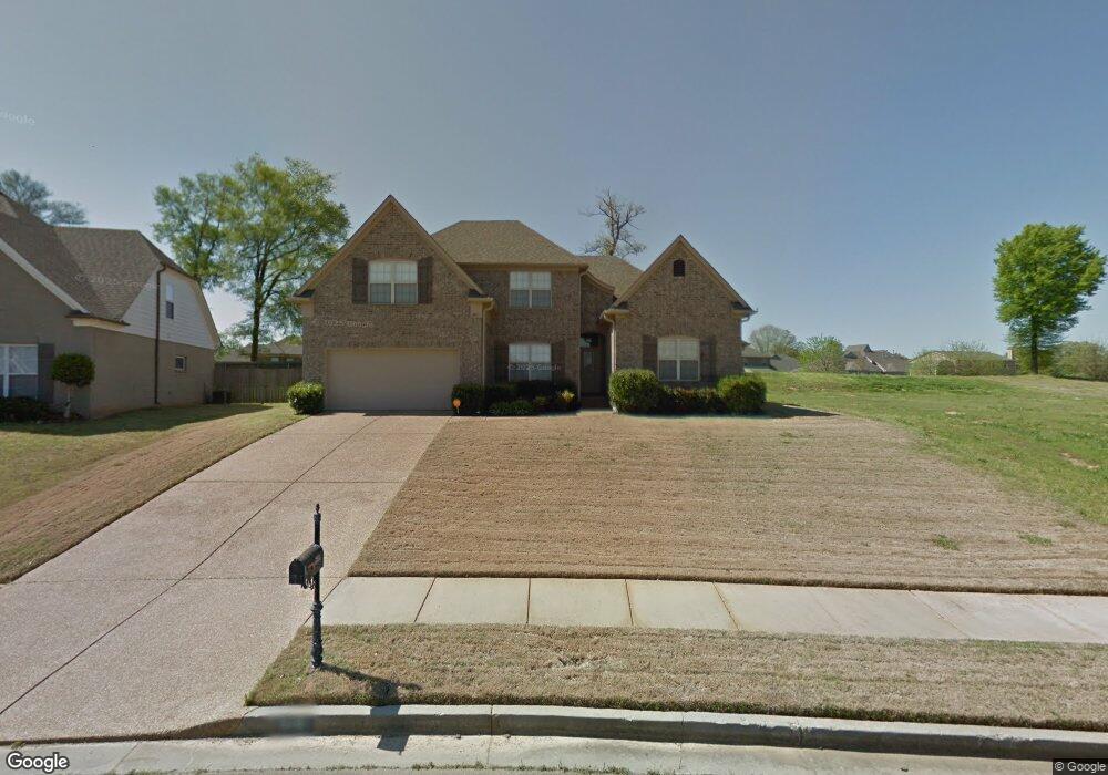
6081 Coleman Rd Olive Branch, MS 38654
Pleasant Hill NeighborhoodEstimated Value: $337,000 - $380,000
4
Beds
3
Baths
2,800
Sq Ft
$128/Sq Ft
Est. Value
About This Home
This home is located at 6081 Coleman Rd, Olive Branch, MS 38654 and is currently estimated at $359,627, approximately $128 per square foot. 6081 Coleman Rd is a home located in DeSoto County with nearby schools including Pleasant Hill Elementary School, DeSoto Central Middle School, and DeSoto Central High School.
Ownership History
Date
Name
Owned For
Owner Type
Purchase Details
Closed on
Jul 28, 2023
Sold by
Hale Rhonda and Hale Sammie
Bought by
Hale Rhonda
Current Estimated Value
Purchase Details
Closed on
Jul 9, 2008
Sold by
Lasalle Bank National Association
Bought by
Hale Rhonda and Hale Sammie
Home Financials for this Owner
Home Financials are based on the most recent Mortgage that was taken out on this home.
Original Mortgage
$185,095
Interest Rate
6.43%
Mortgage Type
Purchase Money Mortgage
Purchase Details
Closed on
Apr 8, 2008
Sold by
Carter Catherine
Bought by
Mortgage Electronic Registration Systems
Create a Home Valuation Report for This Property
The Home Valuation Report is an in-depth analysis detailing your home's value as well as a comparison with similar homes in the area
Home Values in the Area
Average Home Value in this Area
Purchase History
| Date | Buyer | Sale Price | Title Company |
|---|---|---|---|
| Hale Rhonda | -- | None Listed On Document | |
| Hale Rhonda | -- | Summit Title & Escrow Llc | |
| Mortgage Electronic Registration Systems | $158,300 | None Available |
Source: Public Records
Mortgage History
| Date | Status | Borrower | Loan Amount |
|---|---|---|---|
| Previous Owner | Hale Rhonda | $185,095 |
Source: Public Records
Tax History Compared to Growth
Tax History
| Year | Tax Paid | Tax Assessment Tax Assessment Total Assessment is a certain percentage of the fair market value that is determined by local assessors to be the total taxable value of land and additions on the property. | Land | Improvement |
|---|---|---|---|---|
| 2025 | $3,590 | $26,307 | $3,000 | $23,307 |
| 2024 | $2,307 | $19,101 | $3,000 | $16,101 |
| 2023 | $2,307 | $19,101 | $0 | $0 |
| 2022 | $2,307 | $19,101 | $3,000 | $16,101 |
| 2021 | $2,307 | $19,101 | $3,000 | $16,101 |
| 2020 | $2,129 | $17,800 | $3,000 | $14,800 |
| 2019 | $2,129 | $17,800 | $3,000 | $14,800 |
| 2017 | $2,081 | $31,714 | $17,357 | $14,357 |
| 2016 | $2,081 | $17,357 | $3,000 | $14,357 |
| 2015 | $2,381 | $31,714 | $17,357 | $14,357 |
| 2014 | $2,256 | $18,633 | $0 | $0 |
| 2013 | $2,182 | $18,633 | $0 | $0 |
Source: Public Records
Map
Nearby Homes
- 5504 Bunyan Hill Dr
- 5532 Bunyan Hill Dr
- 5400 Bunyan Hill Dr
- 8304 Gum Pond Dr
- 5382 Bunyan Hill Dr
- 5368 Bunyan Hill Dr
- 5380 Braham Dr
- 5350 Bunyan Hill Dr
- 5900 Paloma Dr
- 6643 Hummingbird Cove
- 5283 Borden Creek Dr
- 5287 Borden Creek Dr
- 9095 Willow Branch Dr
- 8146 Wisteria Dr
- 4406 John Wood Ln
- 4432 John Wood Ln
- 8778 Mwc Rd
- 5290 Douglas Dr
- Bristol Plan at Villages at Southbranch
- Lacombe Plan at Villages at Southbranch